Enable Location

We need your location to show you interesting places around you

Discover nearby places

Find interesting locations and hidden gems around you

Precise directions

Get accurate directions and distances to places

Your location is never shared with other users. It's only used when you tap the location button.

Endeavour Bridge

Log in to your account

Start exploring — it's free

Trusted by 61,473 travelers worldwide

Continue with Google
Continue with Apple
or

We will send you a code to connect

By continuing, you accept our Terms and Conditions and our Privacy Policy

Check your inbox

We've sent a pincode in your inbox. Please enter the code below.

Endeavour Bridge

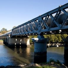
Endeavour Bridge, Road bridge in southern Sydney, Australia

Description

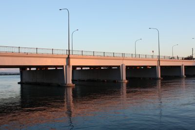
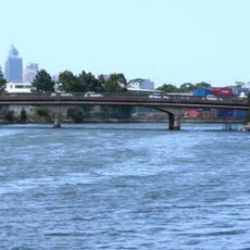
Endeavour Bridge is a road bridge that spans the Cooks River near Botany Bay, connecting the suburbs of Mascot and Kyeemagh. The structure carries traffic along General Holmes Drive and handles daily vehicle crossings over the river.

History

The bridge was completed and officially opened in 1951 as part of infrastructure development supporting Kingsford-Smith Airport expansion. In 1963 it was modified and widened from two separate two-lane structures into a single six-lane crossing.

Culture

The bridge takes its name from HMS Endeavour, the ship that carried James Cook during his exploration of Australia's east coast in 1770. Commuters see this name daily as they cross, creating a tangible link to early European exploration.

Practical

The bridge is part of a major traffic route and experiences heaviest congestion during morning and late afternoon peak hours. It is best to cross during quieter times if possible to avoid delays.

Did you know?

The bridge sits at the point where the Cooks River flows into Botany Bay, a historically significant location as this bay marked the first European landing in Australia. The location at the river mouth connects the traffic hub to one of Australia's most important geographic positions in early history.

Location
Inception
1951
Official opening
May 1951
GPS coordinates
-33.94710,151.16788
Latest update
December 14, 2025 12:25

AroundUs brings together thousands of curated places, local tips, and hidden gems, enriched daily by 60,000 contributors worldwide. Discover all places nearby (New South Wales).

« Endeavour Bridge - Road bridge in southern Sydney, Australia » is provided by Around Us (aroundus.com). Images and texts are derived from Wikimedia project under a Creative Commons license. You are allowed to copy, distribute, and modify copies of this page, under the conditions set by the license, as long as this note is clearly visible.

Discover hidden gems everywhere you go!

From secret cafés to breathtaking viewpoints, skip the crowded tourist spots and find places that match your style. Our app makes it easy with voice search, smart filtering, route optimization, and insider tips from travelers worldwide. Download now for the complete mobile experience.

Around Us App Screenshot

A unique approach to discovering new places

Le Figaro

All the places worth exploring

France Info

A tailor-made excursion in just a few clicks

20 Minutes

Around Us
Travel Guide & Maps
Download

Send to your phone

QR Code
1

Open the camera app on your mobile.

2

Point at the QR code with your camera. A notification will appear.

3

Tap the notification to open the link.