Warrabah National Park, Nature reserve in Tamworth Regional Council, Australia
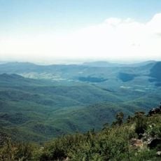
Warrabah National Park lies 371 km north of Sydney, between Kingstown to the east and Split Rock Dam to the west. Its central feature is the Namoi River, which has cut a 15 km gorge dropping 245 m through the plateau. The terrain averages 759 m in elevation, and over 120 bird species have been recorded, from robins and rosellas to cockatoos, wedge-tailed eagles and wrens.
The sources consulted do not record when Warrabah was gazetted or how large the park is, so its founding date and area cannot be stated. What they do establish is the geography that defines it: the park lies 371 km north of Sydney, west of Kingstown and east of Split Rock Dam, about 70 km west of Armidale. Its central feature is the Namoi River, which has cut a 15 km gorge dropping 245 m through the plateau.
The sources record no rock art or sacred sites in the park, so the cultural field turns to what visitors can actually watch: over 120 bird species have been recorded here, from robins, rosellas and cockatoos to wedge-tailed eagles and wrens. The Namoi River gorge is the setting for canoeing, li-loing, rock climbing and bushwalking.
The park lies 371 km north of Sydney, west of Kingstown and east of Split Rock Dam, about 70 km west of Armidale. The Namoi River gorge runs some 15 km and drops 245 m, so canoeing, li-loing, rock climbing and bushwalking are the usual ways to move through it. Plan for the river's changing water levels.
Over 120 bird species have been recorded in the park, from robins, rosellas and cockatoos to wedge-tailed eagles and wrens. Birdwatchers can look for them along the Namoi River gorge, which drops 245 m over its 15 km course.
The community of curious travelers
AroundUs brings together thousands of curated places, local tips, and hidden gems, enriched daily by 93,831 contributors worldwide.