Precipice National Park, Protected natural area in Banana Shire, Australia
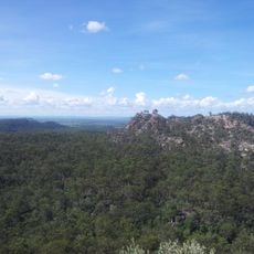
Precipice National Park is a 104-square-kilometre national park in the Darling Downs region of Queensland, about 380 km northwest of Brisbane and 200 km southeast of Gladstone. Its sandstone belt, laid down in the Jurassic about 190 million years ago, has been shaped by uplift and erosion into valleys, cliffs, monoliths and gorges. The land falls from 390 m in the northwest to 165 m on the bank of the Dawson River in the southeast.
The reserve was established in 1998 by the Queensland Department of National Parks, Sport and Racing as a protected conservation area. The creation aimed to safeguard the local ecosystems and natural formations in this region for future generations.
The park's name comes from the English word "precipice", meaning cliff or abyss, referring to the sandstone escarpments within its borders. It lies in the Brigalow Belt South bioregion, named after the brigalow (Acacia harpophylla), a wattle tree up to 25 metres tall that was widespread across the central highlands before European settlement; only about two percent of its original extent survives inside protected areas.
There are no visitor facilities in the park. Access is via the Leichhardt Highway towards Theodore; the park lies about ten kilometres east of the highway, and some agricultural tracks lead close to it. The land rises from 165 metres at the Dawson River in the southeast to 390 metres in the northwest.
The park has no visitor facilities: no trails, no stairs, no iron rungs. Access is via the Leichhardt Highway towards Theodore, with the park lying about ten kilometres east of the road; some agricultural tracks lead near its edge. The Dawson River forms the southeastern boundary at 165 m, while the northwestern rim rises to 390 m.
The community of curious travelers
AroundUs brings together thousands of curated places, local tips, and hidden gems, enriched daily by 94,359 contributors worldwide.