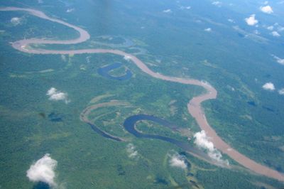
Ramu, Major river in Madang Province, Papua New Guinea
The Ramu is a major river flowing from the Kratke Range through northern Papua New Guinea to the Bismarck Sea. The waterway passes through varied terrain and supports diverse ecosystems along its course.
The river was first explored in 1898 by researcher Ernst Tappenbeck, who created detailed maps of the area. This early expedition significantly contributed to geographic understanding of the region.
Communities along the Lower Ramu maintain traditional practices through mask performances during mourning festivals, which strengthen social bonds and mark important life passages.
Navigation requires caution due to fallen branches and sandbars that can block the water. Water levels vary significantly by season, particularly in the lower sections of the course.
The Yonki Dam on the upper river houses a power station located deep underground near Kainantu. This subterranean facility supplies electricity to highland regions.
The community of curious travelers
AroundUs brings together thousands of curated places, local tips, and hidden gems, enriched daily by 60,000 contributors worldwide.