E. L. Patton Yukon River Bridge

Log in to your account

AroundUs is a community-driven map of interesting places, built by curious explorers like you. It grows with every review, story, and photo you share.
Connect to save your favorite spots, contribute locations, and create personalized routes.
By continuing, you accept our Terms and Conditions and our Privacy Policy

E. L. Patton Yukon River Bridge

Add to collection
Map
Suggest a change
Share

E. L. Patton Yukon River Bridge, Road bridge in Yukon-Koyukuk Census Area, United States.
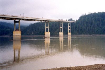
The E. L. Patton Yukon River Bridge stretches 2,295 feet across the Yukon River, connecting Fairbanks to Deadhorse along the Dalton Highway.

Construction of the bridge began in May 1974, with a temporary setback in August due to a cofferdam failure before its official opening in October 1975.

The bridge serves as a critical connection point for local communities, supporting transportation needs and resource movement throughout northern Alaska's remote regions.

The structure features a 30-foot-wide timber driving surface supported by steel deck and box girders, accommodating both vehicle traffic and the Alaska Pipeline.

This engineering achievement stands as the sole bridge crossing the Yukon River in Alaska, integrating both highway transportation and pipeline infrastructure.

Location: Alaska

Official opening: October 10, 1975

GPS coordinates: 65.87470,-149.71100

Latest update: November 28, 2025 14:29

Around this place
Show the full map
Fairbanks Gold Rush
United States of America

Fairbanks Gold Rush

141.2 km
University of Alaska Museum of the North
United States of America

University of Alaska Museum of the North

142.5 km
West Valley High School
United States of America

West Valley High School

143.6 km
Growden Memorial Park
United States of America

Growden Memorial Park

146.5 km
Goldstream Dredge No. 8
United States of America

Goldstream Dredge No. 8

141.3 km
White Mountains National Recreation Area
United States of America

White Mountains National Recreation Area

101.8 km
Harding Railroad Car
United States of America

Harding Railroad Car

146.3 km
Creamer's Field Migratory Waterfowl Refuge
United States of America

Creamer's Field Migratory Waterfowl Refuge

144.6 km
Nenana
United States of America

Nenana

146.3 km
Kanuti National Wildlife Refuge
United States of America

Kanuti National Wildlife Refuge

113 km
Chena Pump House
United States of America

Chena Pump House

143.7 km
Georgeson Botanical Garden
United States of America

Georgeson Botanical Garden

142.3 km
Elmer E. Rasmuson Library
United States of America

Elmer E. Rasmuson Library

143.3 km
Constitution Hall
United States of America

Constitution Hall

143.2 km
Kanuti River
United States of America

Kanuti River

91.5 km
Discovery Claim on Pedro Creek
United States of America

Discovery Claim on Pedro Creek

140.6 km
John Trigg Ester Library
United States of America

John Trigg Ester Library

138.9 km
Wickersham House
United States of America

Wickersham House

146.3 km
Fairbanks Exploration Company Housing
United States of America

Fairbanks Exploration Company Housing

146.8 km
Rainey's Cabin
United States of America

Rainey's Cabin

142.8 km
Fairbanks Exploration Company Machine Shop
United States of America

Fairbanks Exploration Company Machine Shop

146.6 km
Fairbanks Exploration Company Manager's House
United States of America

Fairbanks Exploration Company Manager's House

146.6 km
Rampart Canyon
United States of America

Rampart Canyon

83.2 km
Illinois Street Historic District
United States of America

Illinois Street Historic District

146.8 km
Dall River
United States of America

Dall River

38.4 km
Tolovana River
United States of America

Tolovana River

85.6 km
Ester Camp Historic District
United States of America

Ester Camp Historic District

138.8 km
St. Matthew's Episcopal Church
United States of America

St. Matthew's Episcopal Church

146.8 km
Show the full map

Reviews

Visited this place? Tap the stars to rate it and share your experience / photos with the community! Try now! You can cancel it anytime.

« E. L. Patton Yukon River Bridge - Road bridge in Yukon-Koyukuk Census Area, United States » is provided by Around Us (aroundus.com). Images and texts are derived from Wikimedia project under a Creative Commons license. You are allowed to copy, distribute, and modify copies of this page, under the conditions set by the license, as long as this note is clearly visible.

Discover hidden gems everywhere you go!

From secret cafés to breathtaking viewpoints, skip the crowded tourist spots and find places that match your style. Our app makes it easy with voice search, smart filtering, route optimization, and insider tips from travelers worldwide. Download now for the complete mobile experience.

Around Us App Screenshot

A unique approach to discovering new places

Le Figaro

All the places worth exploring

France Info

A tailor-made excursion in just a few clicks

20 Minutes