Guadalupe Island

Log in to your account

AroundUs is a community-driven map of interesting places, built by curious explorers like you. It grows with every review, story, and photo you share.
Connect to save your favorite spots, contribute locations, and create personalized routes.
Continue with Google
Continue with Apple
Continue with X
Continue with Facebook
Continue with email
By continuing, you accept our Terms and Conditions and our Privacy Policy
Create an account

Guadalupe Island

Add to collection
Map
Suggest a change
Share

Guadalupe Island, Volcanic island in Pacific Ocean, Mexico

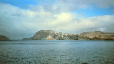
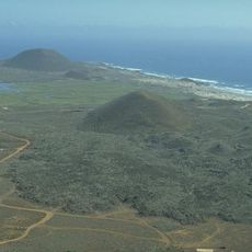
Guadalupe Island rises from the Pacific Ocean about 250 kilometers west of the Baja California Peninsula and belongs to the Mexican state of Baja California. The landmass measures roughly 35 kilometers long and up to 9.5 kilometers wide, formed by two extinct volcanic cones with Mount Augusta as the highest summit at around 1,300 meters (4,300 feet).

Spanish navigator Sebastián Vizcaíno first reached the landmass in 1602 during his expedition along the California coast. Intensive seal and sea otter hunting in the 19th century nearly wiped out these populations before Mexico introduced protection measures.

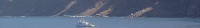
The name comes from the Spanish devotion to Our Lady of Guadalupe and appears on early 17th-century nautical charts. Scientists now use the small research station at Campo Oeste and monitor the seal colonies and the recovery of native plants after goats were removed.

All tourism has been banned since January 2023, and even scientific visits require permits from Mexican authorities. Travel happens by boat or helicopter, and weather can shift quickly, so any stay needs flexible planning.

The waters around this volcanic landmass draw an unusually high number of great white sharks, attracted by clear visibility and large seal colonies. Until the ban in 2023, divers could observe them from special cages, making the region famous worldwide.

Location: Baja California

Location: Ensenada Municipality

Elevation above the sea: 769 m

GPS coordinates: 29.04521,-118.27754

Latest update: December 15, 2025 01:46

Photos
Landscapes and nature of Baja California

Baja California is a Mexican peninsula that offers striking contrasts in its landscapes. Desert valleys meet sandy beaches, while marine reserves protect coastal waters. The region holds ancient cave paintings, volcanic peaks, and colonial-era buildings that tell stories of human settlement. Canyons...

Reviews

Visited this place? Tap the stars to rate it and share your experience / photos with the community! Try now! You can cancel it anytime.

« Guadalupe Island - Volcanic island in Pacific Ocean, Mexico » is provided by Around Us (aroundus.com). Images and texts are derived from Wikimedia project under a Creative Commons license. You are allowed to copy, distribute, and modify copies of this page, under the conditions set by the license, as long as this note is clearly visible.

Discover hidden gems everywhere you go!

From secret cafés to breathtaking viewpoints, skip the crowded tourist spots and find places that match your style. Our app makes it easy with voice search, smart filtering, route optimization, and insider tips from travelers worldwide. Download now for the complete mobile experience.

Around Us App Screenshot

A unique approach to discovering new places

Le Figaro

All the places worth exploring

France Info

A tailor-made excursion in just a few clicks

20 Minutes