Enable Location

We need your location to show you interesting places around you

Discover nearby places

Find interesting locations and hidden gems around you

Precise directions

Get accurate directions and distances to places

Your location is never shared with other users. It's only used when you tap the location button.

Cowles Mountain

Log in to your account

Start exploring — it's free

Trusted by 63,014 travelers worldwide

Continue with Google
Continue with Apple
or

We will send you a code to connect

By continuing, you accept our Terms and Conditions and our Privacy Policy

Check your inbox

We've sent a pincode in your inbox. Please enter the code below.

Cowles Mountain
Discussion Reviews 1 Photos
21.5k Popularity

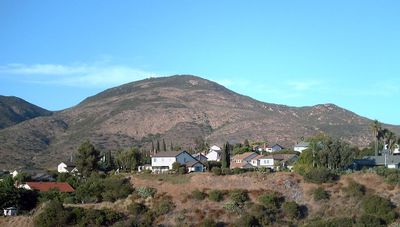
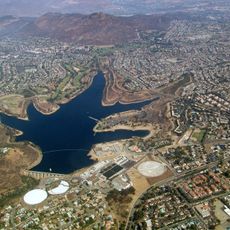
Cowles Mountain, Mountain summit in San Carlos, San Diego, United States.

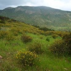
Cowles Mountain is a summit in San Diego rising to 486 meters with a round-trip hiking route of about 3 miles through varied terrain. The main trailhead starts at Golfcrest Drive, and the path gains roughly 290 meters in elevation as it climbs toward the top.

The mountain takes its name from George A. Cowles, a rancher and businessman who held influence in the San Diego region during the 1870s and 1880s. The name honors his role in shaping the area's development.

For decades, students from San Diego State University painted a large letter on the mountainside as a student tradition, until environmental protection rules stopped the practice. This symbol was a recognizable landmark and became part of the local community's sense of place.

The trail is well-marked with multiple routes to the summit, and the main entrance is at Golfcrest Drive. Wear sturdy shoes and bring water, as the path offers little shade during the climb.

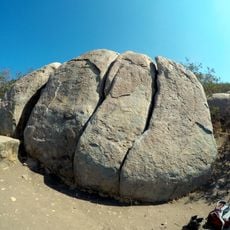
The rock formation consists of Jurassic and Cretaceous metavolcanic rocks that stand out sharply against the sedimentary deposits that surround the area. This geological contrast tells the story of different geological periods at the same location.

The community of curious travelers

AroundUs brings together thousands of curated places, local tips, and hidden gems, enriched daily by 60,000 contributors worldwide.

Start exploring
Location
Elevation above the sea
486 m
GPS coordinates
32.81276,-117.03186
Latest update
December 7, 2025 10:04
Around this place
San Diego Stadium
United States of America

San Diego Stadium

8.8 km
Snapdragon Stadium
United States of America

Snapdragon Stadium

9.1 km
Beth Sarim
United States of America

Beth Sarim

7.8 km
Mission Trails Regional Park
United States of America

Mission Trails Regional Park

2.6 km
Lake Murray
United States of America

Lake Murray

3.2 km
Aztec Bowl
United States of America

Aztec Bowl

5.5 km
Hepner Hall
United States of America

Hepner Hall

5.5 km
Museum of Creation and Earth History
United States of America

Museum of Creation and Earth History

7.6 km
Old Mission Dam
United States of America

Old Mission Dam

3.2 km
Hardy Memorial Tower
United States of America

Hardy Memorial Tower

5.5 km
Edgemoor Farm Dairy Barn
United States of America

Edgemoor Farm Dairy Barn

6.8 km
Aztec Student Union
United States of America

Aztec Student Union

5.6 km
Santee Boulders
United States of America

Santee Boulders

4.3 km
Creation & Earth History Museum & Bookstore
United States of America

Creation & Earth History Museum & Bookstore

7.7 km
San Diego State College
United States of America

San Diego State College

5.5 km
Cal Coast Credit Union Open Air Theatre
United States of America

Cal Coast Credit Union Open Air Theatre

5.6 km
Ken Cinema
United States of America

Ken Cinema

9 km
Physical Sciences Building
United States of America

Physical Sciences Building

5.4 km
ENS Annex
United States of America

ENS Annex

5.7 km
Arts and Letters
United States of America

Arts and Letters

5.5 km
Love Library Addition
United States of America

Love Library Addition

5.5 km
Communication Building
United States of America

Communication Building

5.6 km
Lemon Grove Park
United States of America

Lemon Grove Park

9.3 km
Administration Building
United States of America

Administration Building

5.5 km
Engineering & Interdisciplinary Sciences Complex
United States of America

Engineering & Interdisciplinary Sciences Complex

5.4 km
La Mesa Library
United States of America

La Mesa Library

5.2 km
Music Building
United States of America

Music Building

5.7 km
Geology, Math and Computer Science Building
United States of America

Geology, Math and Computer Science Building

5.3 km
Show the full map
Reviews
Share your experience

No review yet

Discussions
Start a discussion...

No discussion yet

« Cowles Mountain - Mountain summit in San Carlos, San Diego, United States » is provided by Around Us (aroundus.com). Images and texts are derived from Wikimedia project under a Creative Commons license. You are allowed to copy, distribute, and modify copies of this page, under the conditions set by the license, as long as this note is clearly visible.

Discover hidden gems everywhere you go!

From secret cafés to breathtaking viewpoints, skip the crowded tourist spots and find places that match your style. Our app makes it easy with voice search, smart filtering, route optimization, and insider tips from travelers worldwide. Download now for the complete mobile experience.

Around Us App Screenshot

A unique approach to discovering new places

Le Figaro

All the places worth exploring

France Info

A tailor-made excursion in just a few clicks

20 Minutes

Around Us
Travel Guide & Maps
Download

Send to your phone

QR Code
1

Open the camera app on your mobile.

2

Point at the QR code with your camera. A notification will appear.

3

Tap the notification to open the link.