Enable Location

We need your location to show you interesting places around you

Discover nearby places

Find interesting locations and hidden gems around you

Precise directions

Get accurate directions and distances to places

Your location is never shared with other users. It's only used when you tap the location button.

Yorba Hacienda

Log in to your account

Start exploring — it's free

Trusted by 66,106 travelers worldwide

Continue with Google
Continue with Apple
or

We will send you a code to connect

By continuing, you accept our Terms and Conditions and our Privacy Policy

Check your inbox

We've sent a pincode in your inbox. Please enter the code below.

Yorba Hacienda
Discussion Reviews 1 Photos
5.1k Popularity

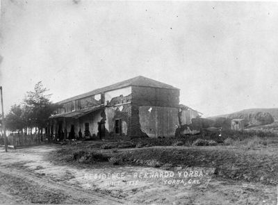
Yorba Hacienda, Mexican era adobe hacienda in Yorba Linda, California.

Yorba Hacienda was an adobe building in Yorba Linda, California, arranged in a U-shape with a southern wall over 100 feet (30 meters) long. The structure held more than 200 rooms, making it one of the largest private residences of the Mexican period in the region.

Bernardo Yorba built this residence between 1835 and 1845 on a land grant during Mexican rule over California. It stood for nearly a century before being demolished in 1926.

The hacienda was a place where food, cloth, and everyday goods were made on site, following Mexican ranching traditions. Visiting the marker today gives a sense of how a large household once ran entirely on its own production.

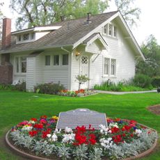
A stone marker with a bronze plaque now stands at the original site and gives basic information about the building. The spot is easy to combine with a visit to other heritage sites in the Yorba Linda area.

The pine beams used in construction were hauled by ox cart from the San Bernardino Mountains, a long journey over rough terrain. This effort shows how much planning went into building on such a remote site with no nearby supply of timber.

The community of curious travelers

AroundUs brings together thousands of curated places, local tips, and hidden gems, enriched daily by 60,000 contributors worldwide.

Start exploring
Location
GPS coordinates
33.86420,-117.78100
Latest update
March 3, 2026 10:07
Around this place
Angel Stadium of Anaheim
United States of America

Angel Stadium of Anaheim

11.8 km
Richard Nixon Presidential Library and Museum
United States of America

Richard Nixon Presidential Library and Museum

4.5 km
Discovery Science Center
United States of America

Discovery Science Center

13.2 km
Birthplace of Richard Nixon
United States of America

Birthplace of Richard Nixon

4.4 km
Chino Hills State Park
United States of America

Chino Hills State Park

12.4 km
City National Grove of Anaheim
United States of America

City National Grove of Anaheim

11.8 km
Irvine Lake
United States of America

Irvine Lake

11.2 km
Old Towne Orange Historic District
United States of America

Old Towne Orange Historic District

11 km
Orange County Zoo
United States of America

Orange County Zoo

8 km
Fullerton Arboretum
United States of America

Fullerton Arboretum

9.8 km
United States of America

Santa Ana Canyon

10 km
Carbon Canyon Regional Park
United States of America

Carbon Canyon Regional Park

8.1 km
A. S. Bradford House
United States of America

A. S. Bradford House

8.1 km
Fox Fullerton Theatre
United States of America

Fox Fullerton Theatre

13.3 km
Irvine Park
United States of America

Irvine Park

8.2 km
Anaheim Carnegie Library
United States of America

Anaheim Carnegie Library

12.7 km
George Key Ranch
United States of America

George Key Ranch

8.8 km
Lewis Ainsworth House
United States of America

Lewis Ainsworth House

10.6 km
Hillcrest Park
United States of America

Hillcrest Park

13.1 km
Brea City Hall and Park
United States of America

Brea City Hall and Park

12.4 km
First Baptist Church of Orange
United States of America

First Baptist Church of Orange

10.8 km
Lydia D. Killefer School
United States of America

Lydia D. Killefer School

10.2 km
Cypress Street Schoolhouse
United States of America

Cypress Street Schoolhouse

11 km
C. Z. Culver House
United States of America

C. Z. Culver House

11 km
Masonic Temple
United States of America

Masonic Temple

13.2 km
Fullerton Odd Fellows Temple
United States of America

Fullerton Odd Fellows Temple

13.2 km
Olinda Oil Museum
United States of America

Olinda Oil Museum

8.6 km
Camelot Golfland Family Fun Center
United States of America

Camelot Golfland Family Fun Center

6.7 km
Show the full map
Reviews
Share your experience

No review yet

Discussions
Start a discussion...

No discussion yet

« Yorba Hacienda - Mexican era adobe hacienda in Yorba Linda, California » is provided by Around Us (aroundus.com). Images and texts are derived from Wikimedia project under a Creative Commons license. You are allowed to copy, distribute, and modify copies of this page, under the conditions set by the license, as long as this note is clearly visible.

Discover hidden gems everywhere you go!

From secret cafés to breathtaking viewpoints, skip the crowded tourist spots and find places that match your style. Our app makes it easy with voice search, smart filtering, route optimization, and insider tips from travelers worldwide. Download now for the complete mobile experience.

Around Us App Screenshot

A unique approach to discovering new places

Le Figaro

All the places worth exploring

France Info

A tailor-made excursion in just a few clicks

20 Minutes

Around Us
Travel Guide & Maps
Download

Send to your phone

QR Code
1

Open the camera app on your mobile.

2

Point at the QR code with your camera. A notification will appear.

3

Tap the notification to open the link.