Enable Location

We need your location to show you interesting places around you

Discover nearby places

Find interesting locations and hidden gems around you

Precise directions

Get accurate directions and distances to places

Your location is never shared with other users. It's only used when you tap the location button.

Poston Butte

Log in to your account

Start exploring — it's free

Trusted by 62,921 travelers worldwide

Continue with Google
Continue with Apple
or

We will send you a code to connect

By continuing, you accept our Terms and Conditions and our Privacy Policy

Check your inbox

We've sent a pincode in your inbox. Please enter the code below.

Poston Butte
Discussion Reviews 1 Photos
3.3k Popularity

Poston Butte, Summit and mountain in Pinal County, United States.

Poston Butte is a mountain in Pinal County, Arizona, with a summit elevation of 1,749 feet composed of basalt formations overlying altered granite. The terrain features a prominence of 223 feet and is accessible via a marked hiking trail.

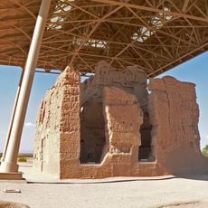
Charles Debrille Poston, an advocate for Arizona's territorial status with President Lincoln, built a pyramidal tomb at the summit during the 1800s. This monument marked his significant role in promoting Arizona's recognition at the federal level.

The area shows signs of early Native American settlements and traditional routes that indigenous communities once traveled. These ancient pathways remain visible in the landscape today, telling the story of their long presence in this region.

A marked trail extends 0.6 miles from Hunt Highway to the summit and requires sturdy footwear and water supplies. Visitors should allow adequate time for the climb and be aware of local conditions.

The pyramidal tomb at the peak features inscriptions detailing Poston's work with Native American affairs. This unusual memorial in the desert is a rare example of personal monuments from that era.

The community of curious travelers

AroundUs brings together thousands of curated places, local tips, and hidden gems, enriched daily by 60,000 contributors worldwide.

Start exploring
Location
GPS coordinates
33.05506,-111.40873
Latest update
December 12, 2025 09:00
Around this place
Interstate 10 in Arizona
United States of America

Interstate 10 in Arizona

36.2 km
Casa Grande Ruins National Monument
United States of America

Casa Grande Ruins National Monument

13.2 km
St. Anthony's Greek Orthodox Monastery
United States of America

St. Anthony's Greek Orthodox Monastery

20.3 km
Boyce Thompson Arboretum
United States of America

Boyce Thompson Arboretum

34.2 km
United States of America

Picketpost Mountain

32.4 km
McFarland State Historic Park
United States of America

McFarland State Historic Park

2.9 km
Second Pinal County Courthouse
United States of America

Second Pinal County Courthouse

3.4 km
United States of America

Peralta Canyon

36.5 km
C.H. Cook Memorial Church
United States of America

C.H. Cook Memorial Church

31.1 km
Rittenhouse Elementary School
United States of America

Rittenhouse Elementary School

31.1 km
Casa Grande Stone Church
United States of America

Casa Grande Stone Church

37.7 km
First Baptist Church
United States of America

First Baptist Church

37.4 km
Gold Canyon Golf Resort
United States of America

Gold Canyon Golf Resort

35.3 km
Our Lady of Guadalupe Church
United States of America

Our Lady of Guadalupe Church

30.5 km
Saint Anthony's Church
United States of America

Saint Anthony's Church

37.8 km
White House
United States of America

White House

37 km
First Presbyterian Church of Florence
United States of America

First Presbyterian Church of Florence

3.5 km
Building at 400 East Third Street
United States of America

Building at 400 East Third Street

37.6 km
Harvey-Niemeyer House
United States of America

Harvey-Niemeyer House

3.5 km
Walter Wilbur House
United States of America

Walter Wilbur House

36.8 km
McFarland State Historic Park
United States of America

McFarland State Historic Park

2.9 km
The Golf Club at Johnson Ranch
United States of America

The Golf Club at Johnson Ranch

18.4 km
Casa Grande City Hall
United States of America

Casa Grande City Hall

37.2 km
Paramount Theatre
United States of America

Paramount Theatre

37.7 km
Isis Theatre
United States of America

Isis Theatre

3 km
Casa Grande Ruins National Monument Visitor Center
United States of America

Casa Grande Ruins National Monument Visitor Center

13.7 km
Sacaton Dam Bridge
United States of America

Sacaton Dam Bridge

26.2 km
Queen Creek Bridge
United States of America

Queen Creek Bridge

27 km
Show the full map
Reviews
Share your experience

No review yet

Discussions
Start a discussion...

No discussion yet

« Poston Butte - Summit and mountain in Pinal County, United States » is provided by Around Us (aroundus.com). Images and texts are derived from Wikimedia project under a Creative Commons license. You are allowed to copy, distribute, and modify copies of this page, under the conditions set by the license, as long as this note is clearly visible.

Discover hidden gems everywhere you go!

From secret cafés to breathtaking viewpoints, skip the crowded tourist spots and find places that match your style. Our app makes it easy with voice search, smart filtering, route optimization, and insider tips from travelers worldwide. Download now for the complete mobile experience.

Around Us App Screenshot

A unique approach to discovering new places

Le Figaro

All the places worth exploring

France Info

A tailor-made excursion in just a few clicks

20 Minutes

Around Us
Travel Guide & Maps
Download

Send to your phone

QR Code
1

Open the camera app on your mobile.

2

Point at the QR code with your camera. A notification will appear.

3

Tap the notification to open the link.