Veterans International Bridge at Los Tomates

Log in to your account

AroundUs is a community-driven map of interesting places, built by curious explorers like you. It grows with every review, story, and photo you share.
Connect to save your favorite spots, contribute locations, and create personalized routes.
By continuing, you accept our Terms and Conditions and our Privacy Policy

Veterans International Bridge at Los Tomates

Add to collection
Map
Suggest a change
Share

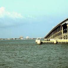
Veterans International Bridge at Los Tomates, Border crossing bridge between Brownsville, United States and Matamoros, Mexico.

The Veterans International Bridge is a road bridge with eight lanes including dedicated SENTRI and FAST lanes and pedestrian walkways on both sides. The structure allows vehicle and foot traffic to cross the Rio Bravo simultaneously in both directions.

The bridge opened in 1999 to handle growing trade and passenger traffic between the United States and Mexico. Its construction was part of a broader effort to improve border crossing capacity in the Cameron County region.

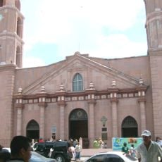
The bridge connects two cities whose residents cross daily for work, shopping, and visiting family on either side. This everyday movement shapes life in the region and shows how deeply the two communities depend on each other.

The crossing is open daily from early morning until midnight, with commercial trucks permitted only during specific hours on weekdays. Visitors should expect lines at the border checkpoint and ensure they have required travel documents ready.

The bridge features dedicated express lanes for SENTRI and FAST program members, allowing pre-screened travelers to cross faster. These programs help frequent border crossers save time and streamline their journeys across the frontier.

Location: Texas

Location: Tamaulipas

Part of: Mexico–United States border

GPS coordinates: 25.88360,-97.47640

Latest update: December 9, 2025 18:47

Photos
Around this place
Queen Isabella Causeway
United States of America

Queen Isabella Causeway

36.6 km
Fort Brown
United States of America

Fort Brown

1.8 km
Gladys Porter Zoo
United States of America

Gladys Porter Zoo

3.8 km
Palo Alto Battlefield National Historical Park
United States of America

Palo Alto Battlefield National Historical Park

16.5 km
Estadio El Hogar
Mexico

Estadio El Hogar

7.2 km
Laguna Atascosa National Wildlife Refuge
United States of America

Laguna Atascosa National Wildlife Refuge

45.5 km
Lower Rio Grande Valley National Wildlife Refuge
United States of America

Lower Rio Grande Valley National Wildlife Refuge

50.5 km
STARGATE
United States of America

STARGATE

31.1 km
Pier 19
United States of America

Pier 19

37.5 km
Isla Blanca Park
United States of America

Isla Blanca Park

37.9 km
Point Isabel Lighthouse
United States of America

Point Isabel Lighthouse

34.5 km
Sabal Palm Sanctuary
United States of America

Sabal Palm Sanctuary

6.8 km
Palmito Ranch Battlefield
United States of America

Palmito Ranch Battlefield

20.4 km
Parque Olímpico
Mexico

Parque Olímpico

2.5 km
Our Lady of Refuge Cathedral, Matamoros
Mexico

Our Lady of Refuge Cathedral, Matamoros

2.7 km
Fuerte Castamata
Mexico

Fuerte Castamata

2.2 km
Immaculate Conception Cathedral
United States of America

Immaculate Conception Cathedral

2.9 km
Resaca de la Palma Battlefield
United States of America

Resaca de la Palma Battlefield

6.1 km
Old Brulay Plantation
United States of America

Old Brulay Plantation

8.3 km
Cameron County Courthouse
United States of America

Cameron County Courthouse

2.9 km
United States Court House, Custom House, and Post Office
United States of America

United States Court House, Custom House, and Post Office

3.1 km
Museo del Ferrocarril de Matamoros
Mexico

Museo del Ferrocarril de Matamoros

3.2 km
Isla Blanca Beach
United States of America

Isla Blanca Beach

38.3 km
Iwo Jima Museum Gift Shop
United States of America

Iwo Jima Museum Gift Shop

42.4 km
Brownsville Heritage Museum
United States of America

Brownsville Heritage Museum

2.8 km
Outdoor theater
Mexico

Outdoor theater

41.8 km
Boca Chica State Park
United States of America

Boca Chica State Park

34.9 km
Del Mar Beach
United States of America

Del Mar Beach

36.2 km
Show the full map
Reviews

Visited this place? Tap the stars to rate it and share your experience / photos with the community! Try now! You can cancel it anytime.

« Veterans International Bridge at Los Tomates - Border crossing bridge between Brownsville, United States and Matamoros, Mexico » is provided by Around Us (aroundus.com). Images and texts are derived from Wikimedia project under a Creative Commons license. You are allowed to copy, distribute, and modify copies of this page, under the conditions set by the license, as long as this note is clearly visible.

Discover hidden gems everywhere you go!

From secret cafés to breathtaking viewpoints, skip the crowded tourist spots and find places that match your style. Our app makes it easy with voice search, smart filtering, route optimization, and insider tips from travelers worldwide. Download now for the complete mobile experience.

Around Us App Screenshot

A unique approach to discovering new places

Le Figaro

All the places worth exploring

France Info

A tailor-made excursion in just a few clicks

20 Minutes