Enable Location

We need your location to show you interesting places around you

Discover nearby places

Find interesting locations and hidden gems around you

Precise directions

Get accurate directions and distances to places

Your location is never shared with other users. It's only used when you tap the location button.

Log in to your account

Start exploring — it's free

Trusted by 64,534 travelers worldwide

Continue with Google
Continue with Apple
or

We will send you a code to connect

By continuing, you accept our Terms and Conditions and our Privacy Policy

Check your inbox

We've sent a pincode in your inbox. Please enter the code below.

Twin Buttes Reservoir
Discussion Reviews Photo
3.5k Popularity

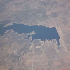
Twin Buttes Reservoir, artificial lake southwest of San Angelo, Texas

Twin Buttes Reservoir is a man-made lake west of San Angelo, Texas, fed by the Middle Concho and South Concho Rivers. The shoreline alternates between rocky stretches, mudflats, and a riprap dam, and the water level can vary noticeably depending on the season and rainfall.

The reservoir was completed in 1963 as part of the San Angelo Project, a federal effort to control flooding and store water from the two Concho Rivers. It has reached full capacity only twice, both times in the 1970s, and has mostly stayed below that level since.

The reservoir draws locals from San Angelo who come to fish, boat, and spend time by the water on weekends and holidays. The open shoreline and lack of crowds make it a place where people tend to settle in quietly for hours at a time.

A limited-use permit is required for camping along the shore, and anglers 17 and older need a valid Texas fishing license. Boat ramps and picnic areas are available, but there are no developed campsites, so bring your own water and supplies.

The reservoir takes its name from two low buttes visible near the original shoreline, a detail most visitors never think to look for. The two landforms are still there in the surrounding landscape and easy to spot once you know what to look for.

The community of curious travelers

AroundUs brings together thousands of curated places, local tips, and hidden gems, enriched daily by 60,000 contributors worldwide.

Start exploring
Location
GPS coordinates
31.34624,-100.53986
Latest update
March 3, 2026 13:59
Around this place
Fort Concho
United States of America

Fort Concho

16 km
Fort Chadbourne
United States of America

Fort Chadbourne

81.6 km
Fort McKavett
United States of America

Fort McKavett

70.8 km
E.V. Spence Reservoir
United States of America

E.V. Spence Reservoir

62.6 km
San Angelo Stadium
United States of America

San Angelo Stadium

12.1 km
Foster Communications Coliseum
United States of America

Foster Communications Coliseum

19.4 km
Foster Field
United States of America

Foster Field

12.9 km
San Angelo Museum of Fine Arts
United States of America

San Angelo Museum of Fine Arts

16 km
Junell Center
United States of America

Junell Center

12.8 km
Olde Park Hotel
United States of America

Olde Park Hotel

71.4 km
Houston Harte University Center
United States of America

Houston Harte University Center

12.7 km
Tom Green County Courthouse
United States of America

Tom Green County Courthouse

16.1 km
J. B. Blakeney House
United States of America

J. B. Blakeney House

15.4 km
Masonic Lodge 570
United States of America

Masonic Lodge 570

16.4 km
Montgomery Ward Building
United States of America

Montgomery Ward Building

16.2 km
Ballinger Carnegie Library
United States of America

Ballinger Carnegie Library

71.1 km
Sutton County Courthouse
United States of America

Sutton County Courthouse

86.7 km
Concho County Courthouse
United States of America

Concho County Courthouse

61.6 km
Old Irion County Courthouse
United States of America

Old Irion County Courthouse

25.3 km
Freeze Building
United States of America

Freeze Building

16 km
Municipal Swimming Pool
United States of America

Municipal Swimming Pool

15.9 km
Fort McKavett State Historic Site
United States of America

Fort McKavett State Historic Site

70.9 km
San Angelo City Hall
United States of America

San Angelo City Hall

16.3 km
Menard County Courthouse
United States of America

Menard County Courthouse

86.6 km
Sterling County Courthouse
United States of America

Sterling County Courthouse

69.2 km
Coke County Courthhouse
United States of America

Coke County Courthhouse

61.1 km
Texas Theater
United States of America

Texas Theater

64.5 km
Texas Theatre
United States of America

Texas Theatre

16.1 km
Show the full map
Reviews
Share your experience

No review yet

Discussions
Start a discussion...

No discussion yet

« Twin Buttes Reservoir - artificial lake southwest of San Angelo, Texas » is provided by Around Us (aroundus.com). Images and texts are derived from Wikimedia project under a Creative Commons license. You are allowed to copy, distribute, and modify copies of this page, under the conditions set by the license, as long as this note is clearly visible.

Discover hidden gems everywhere you go!

From secret cafés to breathtaking viewpoints, skip the crowded tourist spots and find places that match your style. Our app makes it easy with voice search, smart filtering, route optimization, and insider tips from travelers worldwide. Download now for the complete mobile experience.

Around Us App Screenshot

A unique approach to discovering new places

Le Figaro

All the places worth exploring

France Info

A tailor-made excursion in just a few clicks

20 Minutes

Around Us
Travel Guide & Maps
Download

Send to your phone

QR Code
1

Open the camera app on your mobile.

2

Point at the QR code with your camera. A notification will appear.

3

Tap the notification to open the link.