Enable Location

We need your location to show you interesting places around you

Discover nearby places

Find interesting locations and hidden gems around you

Precise directions

Get accurate directions and distances to places

Your location is never shared with other users. It's only used when you tap the location button.

Log in to your account

Start exploring — it's free

Trusted by 62,493 travelers worldwide

Continue with Google
Continue with Apple
or

We will send you a code to connect

By continuing, you accept our Terms and Conditions and our Privacy Policy

Check your inbox

We've sent a pincode in your inbox. Please enter the code below.

Neches River National Wildlife Refuge

Neches River National Wildlife Refuge, National wildlife refuge in Cherokee County, Texas.

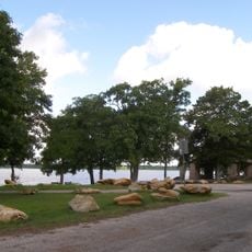
Neches River National Wildlife Refuge is a protected area covering about 7,000 acres of bottomland hardwood forests in Cherokee County. It has eight marked trails of different lengths that wind through various habitats and ecosystems.

The refuge was established in 2006 to protect important habitats for native plants and animals. Its creation was supported by the Texas Conservation Alliance and local conservation groups dedicated to preserving the river ecosystem.

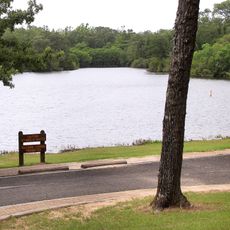
The river has long been central to hunting and fishing for the people who lived here, from Native Americans to early settlers. You can still sense this connection to the water when you walk through the refuge today.

You can reach the refuge from US Highway 79 between Palestine and Jacksonville, with access near the river crossing. Wear sturdy shoes and come prepared for wet, muddy conditions and changing weather typical of forested river areas.

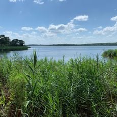
The refuge protects one of the last remaining bottomland hardwood forests in Texas, as more than 90 percent of similar habitats have vanished. This makes it a critical refuge for plants and animals that have lost most of their natural home elsewhere.

The community of curious travelers

AroundUs brings together thousands of curated places, local tips, and hidden gems, enriched daily by 60,000 contributors worldwide.

Start exploring
Location
Inception
2006
Elevation above the sea
84 m
GPS coordinates
31.25000,-95.98333
Latest update
December 12, 2025 17:42
Around this place
Fort Parker State Park
United States of America

Fort Parker State Park

66.7 km
Texas Prison Museum
United States of America

Texas Prison Museum

68.8 km
Fort Boggy State Park
United States of America

Fort Boggy State Park

6.8 km
Mary Allen Seminary
United States of America

Mary Allen Seminary

50.4 km
Fairfield Lake State Park
United States of America

Fairfield Lake State Park

59.7 km
Gibbons Creek Reservoir
United States of America

Gibbons Creek Reservoir

70.1 km
Confederate Reunion Grounds State Historic Site
United States of America

Confederate Reunion Grounds State Historic Site

69.3 km
Millimeter Anisotropy eXperiment IMaging Array
United States of America

Millimeter Anisotropy eXperiment IMaging Array

64 km
Texas State Railroad
United States of America

Texas State Railroad

67.3 km
Museum for East Texas Culture
United States of America

Museum for East Texas Culture

65.9 km
Sacred Heart Catholic Church and School
United States of America

Sacred Heart Catholic Church and School

66 km
Anderson County Courthouse
United States of America

Anderson County Courthouse

66.6 km
State Highway 19 Bridge at Trinity River
United States of America

State Highway 19 Bridge at Trinity River

70.7 km
Howard House
United States of America

Howard House

67.1 km
First Presbyterian Church
United States of America

First Presbyterian Church

66.2 km
Riverside Swinging Bridge
United States of America

Riverside Swinging Bridge

71 km
Mount Vernon African Methodist Episcopal Church
United States of America

Mount Vernon African Methodist Episcopal Church

67.1 km
Franklin Carnegie Library
United States of America

Franklin Carnegie Library

53.8 km
Trinity and Brazos Valley Railroad Depot and Office Building
United States of America

Trinity and Brazos Valley Railroad Depot and Office Building

50.7 km
First United Methodist Church
United States of America

First United Methodist Church

50.8 km
Madison County Courthouse
United States of America

Madison County Courthouse

34.2 km
Woodbine Hotel and Restaurant
United States of America

Woodbine Hotel and Restaurant

34 km
Confederate Reunion Grounds State Historic Site
United States of America

Confederate Reunion Grounds State Historic Site

69.3 km
Houston County Courthouse
United States of America

Houston County Courthouse

50.6 km
Robertson County Courthouse
United States of America

Robertson County Courthouse

54.1 km
Texas Theater
United States of America

Texas Theater

66.1 km
John H. Reagan Statue
United States of America

John H. Reagan Statue

66 km
Palestine High School
United States of America

Palestine High School

65.9 km
Show the full map
« Neches River National Wildlife Refuge - National wildlife refuge in Cherokee County, Texas » is provided by Around Us (aroundus.com). Images and texts are derived from Wikimedia project under a Creative Commons license. You are allowed to copy, distribute, and modify copies of this page, under the conditions set by the license, as long as this note is clearly visible.

Discover hidden gems everywhere you go!

From secret cafés to breathtaking viewpoints, skip the crowded tourist spots and find places that match your style. Our app makes it easy with voice search, smart filtering, route optimization, and insider tips from travelers worldwide. Download now for the complete mobile experience.

Around Us App Screenshot

A unique approach to discovering new places

Le Figaro

All the places worth exploring

France Info

A tailor-made excursion in just a few clicks

20 Minutes

Around Us
Travel Guide & Maps
Download

Send to your phone

QR Code
1

Open the camera app on your mobile.

2

Point at the QR code with your camera. A notification will appear.

3

Tap the notification to open the link.