State Highway 79 Bridge at the Red River

Log in to your account

AroundUs is a community-driven map of interesting places, built by curious explorers like you. It grows with every review, story, and photo you share.
Connect to save your favorite spots, contribute locations, and create personalized routes.
Continue with Google
Continue with Apple
Continue with X
Continue with Facebook
Continue with email
By continuing, you accept our Terms and Conditions and our Privacy Policy
Create an account
Add to collection
Map
Suggest a change
Share

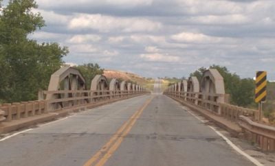
State Highway 79 Bridge at the Red River, Historic bridge across Red River between Oklahoma and Texas, United States.

The State Highway 79 Bridge is a road crossing over the Red River connecting Oklahoma and Texas, featuring a distinctive truss structure with multiple spans. The structure is designed with multiple arched segments that create its recognizable appearance.

The structure was constructed in the late 1930s as a joint effort between the transportation authorities of Texas and Oklahoma to improve regional connectivity. It later earned recognition as a historic site due to its significance as an engineering achievement of that era.

The bridge served as the main crossing point linking communities on either side of the river and shaped the landscape for generations of residents. People relied on it to travel between neighboring regions and conduct daily business across the state border.

The crossing remains open to vehicular traffic and provides a direct two-lane route between the two states. Visitors can walk or drive across, though they should expect normal traffic conditions typical of regional highways.

The structure belonged to a rare group of bridges featuring a special truss design that is seldom found in this region. This distinctive construction method made it a notable example for engineers and those interested in historic infrastructure.

Location: Oklahoma

Location: Texas

Location: Jefferson County

Address: OK 79 across the Red River at the OK-TX state line

GPS coordinates: 34.13220,-98.09420

Latest update: December 14, 2025 14:43

Photos
Around this place
Newby-McMahon Building
United States of America

Newby-McMahon Building

43.8 km
Professional Wrestling Hall of Fame and Museum
United States of America

Professional Wrestling Hall of Fame and Museum

44.1 km
Memorial Stadium
United States of America

Memorial Stadium

54.7 km
Comanche Nation Casino
United States of America

Comanche Nation Casino

58.5 km
Chisholm Trail Casino
United States of America

Chisholm Trail Casino

51.7 km
Wichita Falls Railroad Museum
United States of America

Wichita Falls Railroad Museum

43.8 km
Apache Casino Hotel
United States of America

Apache Casino Hotel

58.2 km
Mattie Beal House
United States of America

Mattie Beal House

58.5 km
The Kell House
United States of America

The Kell House

44.8 km
Call Field
United States of America

Call Field

51.5 km
First Christian Church
United States of America

First Christian Church

59.5 km
Carnegie Library
United States of America

Carnegie Library

59.6 km
Irving Baptist Church
United States of America

Irving Baptist Church

10.6 km
First United Methodist Church
United States of America

First United Methodist Church

32 km
Brittain-Garvin House
United States of America

Brittain-Garvin House

43.6 km
First Presbyterian Church
United States of America

First Presbyterian Church

9.3 km
H.C. Chrislip House
United States of America

H.C. Chrislip House

43.8 km
Chisholm Trail Heritage Center & Garis Gallery of the American West
United States of America

Chisholm Trail Heritage Center & Garis Gallery of the American West

43.9 km
Historic Mattie Beal Home
United States of America

Historic Mattie Beal Home

58.5 km
Wichita Theatre and Opera House
United States of America

Wichita Theatre and Opera House

44 km
Kell House Museum
United States of America

Kell House Museum

44.8 km
Shepler Square Park
United States of America

Shepler Square Park

59.8 km
Lawton Federal Building and United States Courthouse
United States of America

Lawton Federal Building and United States Courthouse

59.3 km
Tales N' Trails Museum
United States of America

Tales N' Trails Museum

52.5 km
Lake Wichita
United States of America

Lake Wichita

54.3 km
Comanche Red River Hotel Casino
United States of America

Comanche Red River Hotel Casino

39.8 km
Morningside Historic District
United States of America

Morningside Historic District

47 km
Depot Square Historic District
United States of America

Depot Square Historic District

43.9 km
Show the full map
Reviews

Visited this place? Tap the stars to rate it and share your experience / photos with the community! Try now! You can cancel it anytime.

« State Highway 79 Bridge at the Red River - Historic bridge across Red River between Oklahoma and Texas, United States » is provided by Around Us (aroundus.com). Images and texts are derived from Wikimedia project under a Creative Commons license. You are allowed to copy, distribute, and modify copies of this page, under the conditions set by the license, as long as this note is clearly visible.

Discover hidden gems everywhere you go!

From secret cafés to breathtaking viewpoints, skip the crowded tourist spots and find places that match your style. Our app makes it easy with voice search, smart filtering, route optimization, and insider tips from travelers worldwide. Download now for the complete mobile experience.

Around Us App Screenshot

A unique approach to discovering new places

Le Figaro

All the places worth exploring

France Info

A tailor-made excursion in just a few clicks

20 Minutes