Enable Location

We need your location to show you interesting places around you

Discover nearby places

Find interesting locations and hidden gems around you

Precise directions

Get accurate directions and distances to places

Your location is never shared with other users. It's only used when you tap the location button.

Log in to your account

Start exploring — it's free

Trusted by 68,240 travelers worldwide

Continue with Google
Continue with Apple
or

We will send you a code to connect

By continuing, you accept our Terms and Conditions and our Privacy Policy

Check your inbox

We've sent a pincode in your inbox. Please enter the code below.

Gahagan Mounds Site
Discussion Reviews Photo
3.1k Popularity

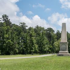
Gahagan Mounds Site, Archaeological burial site in Red River Parish, Louisiana, United States.

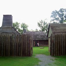
Gahagan Mounds Site is an archaeological location with a raised platform mound, a burial mound shaped like a cone, and a central plaza with surrounding residential structures. The layout shows a planned arrangement of spaces used for different purposes by its inhabitants.

The site was inhabited between 900 and 1200 by the Early Caddoan Mississippian culture. Excavations uncovered fourteen burials located in three deep shafts dug into the ground.

The artifacts found here reflect trade connections between distant communities, with objects from faraway places showing how indigenous groups exchanged goods across long distances.

The site sits along the Red River in the western part of the region, positioned between two major towns. Most artifacts discovered here are now kept and displayed at a university museum for public access.

The site yielded an unusually large collection of burial goods, with over five hundred objects found in the graves. Among them were specialized stone blades that came from distant stone sources in the southwest, revealing the remarkable reach of these trade routes.

The community of curious travelers

AroundUs brings together thousands of curated places, local tips, and hidden gems, enriched daily by 60,000 contributors worldwide.

Start exploring
Location
GPS coordinates
32.04030,-93.40530
Latest update
December 12, 2025 12:01
Around this place
Los Adaes
United States of America

Los Adaes

38.4 km
Fort Jesup
United States of America

Fort Jesup

47.7 km
Black Lake
United States of America

Black Lake

35.1 km
Lake Bistineau State Park
United States of America

Lake Bistineau State Park

45 km
Harry Turpin Stadium
United States of America

Harry Turpin Stadium

43.8 km
Fort St. Jean Baptiste State Historic Site
United States of America

Fort St. Jean Baptiste State Historic Site

43.9 km
Basilica of the Immaculate Conception
United States of America

Basilica of the Immaculate Conception

43.2 km
Rebel State Historic Site
United States of America

Rebel State Historic Site

44.2 km
Natchitoches Historic District
United States of America

Natchitoches Historic District

43.5 km
Kepler Lake
United States of America

Kepler Lake

44.5 km
Church of St. Anne
United States of America

Church of St. Anne

30.5 km
Bryan House
United States of America

Bryan House

47.9 km
Robeline Methodist Church
United States of America

Robeline Methodist Church

40.1 km
DeSoto Parish Courthouse
United States of America

DeSoto Parish Courthouse

28.8 km
Union Church
United States of America

Union Church

49.3 km
Old Courthouse Museum
United States of America

Old Courthouse Museum

43.2 km
Grand Cane United Methodist Church
United States of America

Grand Cane United Methodist Church

38.3 km
Guy House
United States of America

Guy House

26.4 km
Mansfield State Historic Site
United States of America

Mansfield State Historic Site

24.7 km
Cheveron
United States of America

Cheveron

45.3 km
Fort St. Jean Baptiste
United States of America

Fort St. Jean Baptiste

43.9 km
Shop Rite
United States of America

Shop Rite

44.1 km
Davis Springs Methodist Church
United States of America

Davis Springs Methodist Church

24.7 km
Natchitoches Parish Library
United States of America

Natchitoches Parish Library

32.3 km
Port of Natchitoches
United States of America

Port of Natchitoches

39 km
Bank of Montgomery Washington Street Branch
United States of America

Bank of Montgomery Washington Street Branch

43.1 km
Church Street Bridge
United States of America

Church Street Bridge

43.4 km
Normal Hill Historic District
United States of America

Normal Hill Historic District

43.4 km
Show the full map
Reviews
Share your experience

No review yet

Discussions
Start a discussion...

No discussion yet

« Gahagan Mounds Site - Archaeological burial site in Red River Parish, Louisiana, United States » is provided by Around Us (aroundus.com). Images and texts are derived from Wikimedia project under a Creative Commons license. You are allowed to copy, distribute, and modify copies of this page, under the conditions set by the license, as long as this note is clearly visible.

Discover hidden gems everywhere you go!

From secret cafés to breathtaking viewpoints, skip the crowded tourist spots and find places that match your style. Our app makes it easy with voice search, smart filtering, route optimization, and insider tips from travelers worldwide. Download now for the complete mobile experience.

Around Us App Screenshot

A unique approach to discovering new places

Le Figaro

All the places worth exploring

France Info

A tailor-made excursion in just a few clicks

20 Minutes

Around Us
Travel Guide & Maps
Download

Send to your phone

QR Code
1

Open the camera app on your mobile.

2

Point at the QR code with your camera. A notification will appear.

3

Tap the notification to open the link.