Enable Location

We need your location to show you interesting places around you

Discover nearby places

Find interesting locations and hidden gems around you

Precise directions

Get accurate directions and distances to places

Your location is never shared with other users. It's only used when you tap the location button.

Horace Wilkinson Bridge

Log in to your account

Start exploring — it's free

Trusted by 61,469 travelers worldwide

Continue with Google
Continue with Apple
or

We will send you a code to connect

By continuing, you accept our Terms and Conditions and our Privacy Policy

Check your inbox

We've sent a pincode in your inbox. Please enter the code below.

Horace Wilkinson Bridge

Horace Wilkinson Bridge, Cantilever road bridge in Baton Rouge, United States.

Description

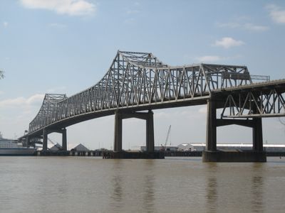
The Horace Wilkinson Bridge is a steel cantilever span crossing the Mississippi River at Baton Rouge in Louisiana. The structure links East Baton Rouge and West Baton Rouge parishes and carries Interstate 10 over the waterway.

History

The crossing opened on April 10, 1968, and took its name from three generations of the Wilkinson family who together served 54 years in the state legislature. Planning began in the early 1960s to handle growing traffic between both riverbanks.

Culture

Residents call this crossing the New Bridge to set it apart from the older span over the river in the area. The nickname shows how the structure serves as the modern alternative in the local road network.

Practical

Traffic often slows at the point where Interstate 10 and Interstate 110 merge and three lanes narrow into one through lane. Drivers should plan extra travel time especially during weekday peak hours.

Did you know?

With a clearance of 53 meters above the water, this crossing is the tallest span over the entire course of the Mississippi. The height allows large river vessels and barges to pass underneath without obstruction.

Location
Inception
April 10, 1968
Official opening
April 10, 1968
Length
4,313 m
Longest Span
376 m
Made from material
steel
GPS coordinates
30.43950,-91.19650
Latest update
December 5, 2025 22:29

AroundUs brings together thousands of curated places, local tips, and hidden gems, enriched daily by 60,000 contributors worldwide. Discover all places nearby (Louisiana).

Around this place
USS Kidd
United States of America

USS Kidd

684 m
Louisiana State Capitol
United States of America

Louisiana State Capitol

2.1 km
Old Louisiana State Capitol
United States of America

Old Louisiana State Capitol

1.1 km
Louisiana Governor's Mansion
United States of America

Louisiana Governor's Mansion

2.6 km
Old Louisiana Governor's Mansion
United States of America

Old Louisiana Governor's Mansion

1.3 km
Hilton Baton Rouge Capitol Center
United States of America

Hilton Baton Rouge Capitol Center

1.2 km
Pentagon Barracks Museum
United States of America

Pentagon Barracks Museum

1.9 km
Pentagon Barracks
United States of America

Pentagon Barracks

1.9 km
Shaw Center for the Arts
United States of America

Shaw Center for the Arts

1.2 km
Catedral de San José
United States of America

Catedral de San José

1.7 km
Yazoo and Mississippi Valley Railroad Company Depot
United States of America

Yazoo and Mississippi Valley Railroad Company Depot

945 m
Capitol Park Museum
United States of America

Capitol Park Museum

1.9 km
One American Place
United States of America

One American Place

1.6 km
Fort New Richmond
United States of America

Fort New Richmond

1.8 km
Aillet House
United States of America

Aillet House

2.4 km
Odell S. Williams Now And Then African-American Museum
United States of America

Odell S. Williams Now And Then African-American Museum

1.1 km
Baton Rouge City Club
United States of America

Baton Rouge City Club

1.2 km
13th Gate Necropolis
United States of America

13th Gate Necropolis

833 m
Prince Hall Masonic Temple
United States of America

Prince Hall Masonic Temple

2.2 km
Riverfront Plaza/Levee Green
United States of America

Riverfront Plaza/Levee Green

814 m
Main Street Historic District
United States of America

Main Street Historic District

1.7 km
Reiley-Reeves House
United States of America

Reiley-Reeves House

2.7 km
LSU Museum of Art
United States of America

LSU Museum of Art

1.2 km
Magnolia Mound Plantation
United States of America

Magnolia Mound Plantation

1.7 km
West Baton Rouge Parish Museum
United States of America

West Baton Rouge Parish Museum

2.5 km
Lincoln Theater
United States of America

Lincoln Theater

2 km
McKinley High School
United States of America

McKinley High School

1.8 km
Spanish Town Road Park
United States of America

Spanish Town Road Park

2.5 km
Show the full map
« Horace Wilkinson Bridge - Cantilever road bridge in Baton Rouge, United States » is provided by Around Us (aroundus.com). Images and texts are derived from Wikimedia project under a Creative Commons license. You are allowed to copy, distribute, and modify copies of this page, under the conditions set by the license, as long as this note is clearly visible.

Discover hidden gems everywhere you go!

From secret cafés to breathtaking viewpoints, skip the crowded tourist spots and find places that match your style. Our app makes it easy with voice search, smart filtering, route optimization, and insider tips from travelers worldwide. Download now for the complete mobile experience.

Around Us App Screenshot

A unique approach to discovering new places

Le Figaro

All the places worth exploring

France Info

A tailor-made excursion in just a few clicks

20 Minutes

Around Us
Travel Guide & Maps
Download

Send to your phone

QR Code
1

Open the camera app on your mobile.

2

Point at the QR code with your camera. A notification will appear.

3

Tap the notification to open the link.