Enable Location

We need your location to show you interesting places around you

Discover nearby places

Find interesting locations and hidden gems around you

Precise directions

Get accurate directions and distances to places

Your location is never shared with other users. It's only used when you tap the location button.

Poison Springs Battleground State Park

Log in to your account

Start exploring — it's free

Trusted by 61,342 travelers worldwide

Continue with Google
Continue with Apple
or

We will send you a code to connect

By continuing, you accept our Terms and Conditions and our Privacy Policy

Check your inbox

We've sent a pincode in your inbox. Please enter the code below.

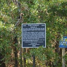
Poison Springs Battleground State Park, Civil War battlefield park in Chidester, United States.

Description

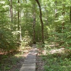
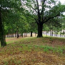
Poison Springs Battleground State Park is an 85-acre protected area in Ouachita County with preserved battlefield grounds and walking trails. The site stretches through dense pine and oak forests near Highway 76, displaying features that reflect its 19th-century wartime landscape.

History

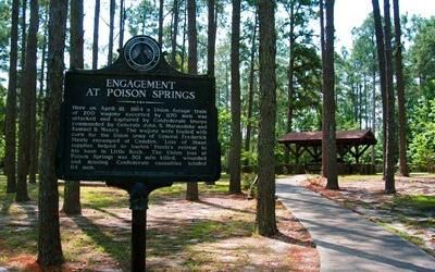
The site was the location of an 1864 attack by Confederate and Choctaw forces on a Union supply wagon during a broader military campaign. This engagement affected supply routes and troop movements across the region.

Culture

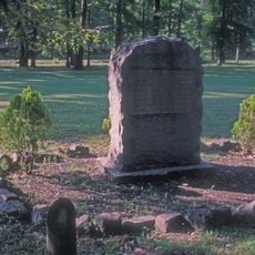
The trails here tell the stories of soldiers and the participation of Native Americans in this conflict. Visitors can today understand the perspectives of different groups involved in this battle.

Practical

The park provides picnic areas, walking trails, and informational displays for exploring the grounds. The paths are designed so visitors can traverse the battlefield on foot while experiencing the natural surroundings.

Did you know?

The site's name comes from a story about soldiers contaminating a water source during the fighting. This account is part of local memory and remains part of how the engagement is remembered.

Location
Inception
1961
Elevation above the sea
90 m
Part of
Arkansas Heritage Trails System
GPS coordinates
33.63761,-93.00600
Latest update
December 12, 2025 09:06

AroundUs brings together thousands of curated places, local tips, and hidden gems, enriched daily by 60,000 contributors worldwide. Discover all places nearby (Ouachita County).

Around this place
White Oak Lake State Park
United States of America

White Oak Lake State Park

11.6 km
Fort Southerland
United States of America

Fort Southerland

18.8 km
Camden Expedition Sites National Historic Landmark
United States of America

Camden Expedition Sites National Historic Landmark

17 km
Camden Confederate Monument
United States of America

Camden Confederate Monument

17.3 km
Fort Lookout
United States of America

Fort Lookout

16.4 km
McCollum-Chidester House
United States of America

McCollum-Chidester House

16.3 km
McNeely Creek Bridge
United States of America

McNeely Creek Bridge

33.6 km
Sidney A. Umsted House
United States of America

Sidney A. Umsted House

17 km
Ouachita County Courthouse
United States of America

Ouachita County Courthouse

17.3 km
Rumph House
United States of America

Rumph House

16.5 km
Bragg House
United States of America

Bragg House

11.8 km
Oakland Farm
United States of America

Oakland Farm

18.2 km
Ben Laney Bridge
United States of America

Ben Laney Bridge

18 km
Arkansas Highway 57 Bridge
United States of America

Arkansas Highway 57 Bridge

25.7 km
Two Bayou Methodist Church and Cemetery
United States of America

Two Bayou Methodist Church and Cemetery

11.1 km
Carolina Methodist Church
United States of America

Carolina Methodist Church

15.9 km
Ed Knight House
United States of America

Ed Knight House

32.3 km
Leake–Ingham Building
United States of America

Leake–Ingham Building

16.1 km
Capt. John T. Burkett House
United States of America

Capt. John T. Burkett House

29.4 km
Hickman House
United States of America

Hickman House

19.9 km
Elliott-Meek House
United States of America

Elliott-Meek House

16.4 km
Mount Prospect Methodist Church
United States of America

Mount Prospect Methodist Church

30.6 km
Dennis and Christine Garrison House
United States of America

Dennis and Christine Garrison House

25.7 km
Tate's Barn
United States of America

Tate's Barn

18.4 km
Graham-Gaughan-Betts House
United States of America

Graham-Gaughan-Betts House

16.5 km
Benjamin T. Powell House
United States of America

Benjamin T. Powell House

17.2 km
St. John's Episcopal Church
United States of America

St. John's Episcopal Church

17.1 km
Richmond-Tufts House
United States of America

Richmond-Tufts House

9.7 km
Show the full map
« Poison Springs Battleground State Park - Civil War battlefield park in Chidester, United States » is provided by Around Us (aroundus.com). Images and texts are derived from Wikimedia project under a Creative Commons license. You are allowed to copy, distribute, and modify copies of this page, under the conditions set by the license, as long as this note is clearly visible.

Discover hidden gems everywhere you go!

From secret cafés to breathtaking viewpoints, skip the crowded tourist spots and find places that match your style. Our app makes it easy with voice search, smart filtering, route optimization, and insider tips from travelers worldwide. Download now for the complete mobile experience.

Around Us App Screenshot

A unique approach to discovering new places

Le Figaro

All the places worth exploring

France Info

A tailor-made excursion in just a few clicks

20 Minutes

Around Us
Travel Guide & Maps
Download

Send to your phone

QR Code
1

Open the camera app on your mobile.

2

Point at the QR code with your camera. A notification will appear.

3

Tap the notification to open the link.