Enable Location

We need your location to show you interesting places around you

Discover nearby places

Find interesting locations and hidden gems around you

Precise directions

Get accurate directions and distances to places

Your location is never shared with other users. It's only used when you tap the location button.

Fort Southerland

Log in to your account

Start exploring — it's free

Trusted by 62,806 travelers worldwide

Continue with Google
Continue with Apple
or

We will send you a code to connect

By continuing, you accept our Terms and Conditions and our Privacy Policy

Check your inbox

We've sent a pincode in your inbox. Please enter the code below.

Fort Southerland, Civil War redoubt in Camden, United States.

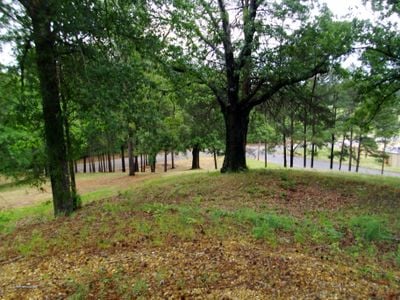
Fort Southerland is an oval-shaped earthwork in Camden designed to hold artillery in three separate firing positions. The structure spans an area roughly the size of a city block and shows the layout of its defensive design.

Confederate forces built the fort in early 1864 as part of Camden's defensive network following the Union capture of Little Rock. The site changed hands between Confederate and Union forces in April 1864, with both sides making structural improvements.

The fort held meaning for local residents as a reminder of the region's struggle during wartime. Walking around today, you can sense how this place marked the landscape and shaped memories for generations afterward.

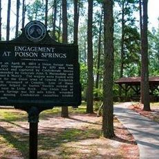
The site is open to the public through Fort Southerland Park with walking paths that guide you around the earthworks. Interpretive signs along the route explain what you are seeing and why each part of the fort mattered.

The fort was built quickly under wartime pressure, with soldiers working fast to complete the earthworks before attack. You can still see evidence of this rushed construction in how the soil is layered and shaped along the walls.

The community of curious travelers

AroundUs brings together thousands of curated places, local tips, and hidden gems, enriched daily by 60,000 contributors worldwide.

Start exploring
Location
GPS coordinates
33.57389,-92.81806
Latest update
December 6, 2025 17:46
Uncommon places to visit in Arkansas

Arkansas sits in the southern United States, where the Ozark and Ouachita mountains meet forested valleys and slow rivers. Away from the main highways, the state holds waterfalls hidden in national forests, abandoned settlements from mining days, and caves filled with limestone formations. Haw Creek...

Around this place
Poison Springs Battleground State Park
United States of America

Poison Springs Battleground State Park

18.8 km
Camden Expedition Sites National Historic Landmark
United States of America

Camden Expedition Sites National Historic Landmark

1.9 km
J.T. Murphy No 1 Crater
United States of America

J.T. Murphy No 1 Crater

29.1 km
Camden Confederate Monument
United States of America

Camden Confederate Monument

1.7 km
Fort Lookout
United States of America

Fort Lookout

3.4 km
McCollum-Chidester House
United States of America

McCollum-Chidester House

2.5 km
Sidney A. Umsted House
United States of America

Sidney A. Umsted House

2 km
Ouachita County Courthouse
United States of America

Ouachita County Courthouse

1.6 km
Rumph House
United States of America

Rumph House

2.4 km
Bragg House
United States of America

Bragg House

7.5 km
Oakland Farm
United States of America

Oakland Farm

4.4 km
Ben Laney Bridge
United States of America

Ben Laney Bridge

2.6 km
Arkansas Highway 57 Bridge
United States of America

Arkansas Highway 57 Bridge

29.4 km
Two Bayou Methodist Church and Cemetery
United States of America

Two Bayou Methodist Church and Cemetery

13.8 km
Leake–Ingham Building
United States of America

Leake–Ingham Building

2.7 km
Capt. John T. Burkett House
United States of America

Capt. John T. Burkett House

15 km
Elliott-Meek House
United States of America

Elliott-Meek House

2.5 km
Hickman House
United States of America

Hickman House

7.7 km
D. McDonald House
United States of America

D. McDonald House

24.9 km
Bearden Waterworks
United States of America

Bearden Waterworks

25.3 km
Dunn House
United States of America

Dunn House

28 km
Dennis and Christine Garrison House
United States of America

Dennis and Christine Garrison House

29.4 km
Tate's Barn
United States of America

Tate's Barn

4.4 km
Graham-Gaughan-Betts House
United States of America

Graham-Gaughan-Betts House

2.4 km
Benjamin T. Powell House
United States of America

Benjamin T. Powell House

1.6 km
St. John's Episcopal Church
United States of America

St. John's Episcopal Church

1.9 km
Capt. Goodgame House
United States of America

Capt. Goodgame House

29 km
Richmond-Tufts House
United States of America

Richmond-Tufts House

9.2 km
Show the full map
« Fort Southerland - Civil War redoubt in Camden, United States » is provided by Around Us (aroundus.com). Images and texts are derived from Wikimedia project under a Creative Commons license. You are allowed to copy, distribute, and modify copies of this page, under the conditions set by the license, as long as this note is clearly visible.

Discover hidden gems everywhere you go!

From secret cafés to breathtaking viewpoints, skip the crowded tourist spots and find places that match your style. Our app makes it easy with voice search, smart filtering, route optimization, and insider tips from travelers worldwide. Download now for the complete mobile experience.

Around Us App Screenshot

A unique approach to discovering new places

Le Figaro

All the places worth exploring

France Info

A tailor-made excursion in just a few clicks

20 Minutes

Around Us
Travel Guide & Maps
Download

Send to your phone

QR Code
1

Open the camera app on your mobile.

2

Point at the QR code with your camera. A notification will appear.

3

Tap the notification to open the link.