Enable Location

We need your location to show you interesting places around you

Discover nearby places

Find interesting locations and hidden gems around you

Precise directions

Get accurate directions and distances to places

Your location is never shared with other users. It's only used when you tap the location button.

Old Vicksburg Bridge

Log in to your account

Start exploring — it's free

Trusted by 61,821 travelers worldwide

Continue with Google
Continue with Apple
or

We will send you a code to connect

By continuing, you accept our Terms and Conditions and our Privacy Policy

Check your inbox

We've sent a pincode in your inbox. Please enter the code below.

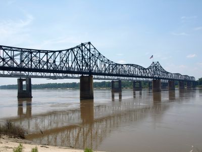
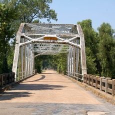
Old Vicksburg Bridge, Railroad bridge in Vicksburg, United States.

Description

The Old Vicksburg Bridge is a steel cantilever structure that spans the Mississippi River, connecting Vicksburg in Mississippi to Delta in Louisiana. The framework consists of interlocking steel beams that form a distinctive lattice pattern visible from far across the river valley.

History

The project emerged in the 1920s as an effort to improve regional transportation connections and was completed after several years of construction. It was a technical innovation for crossing the river and enabled continuous rail service across the waterway in that part of the region.

Culture

The bridge served as a vital link between two states and shaped how the region saw itself as a major transportation corridor. Today, its towering steel structure remains a recognizable landmark that defines the local landscape.

Practical

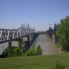
The bridge is easily visible from public viewpoints along the riverbank and can be photographed, with the best perspectives from the Mississippi side. Visitors should be aware of train movements and use only designated viewing areas to stay safe.

Did you know?

Before its conversion to rail-only use, the bridge transported vehicles and relied on special signal towers for traffic control. This dual-purpose operation made it an unusual example of a multipurpose crossing over major American rivers.

Location
Location
Inception
1920s
Official opening
May 1, 1930
GPS coordinates
32.31500,-90.90556
Latest update
December 9, 2025 18:40

AroundUs brings together thousands of curated places, local tips, and hidden gems, enriched daily by 60,000 contributors worldwide. Discover all places nearby (Vicksburg).

Around this place
McRaven House
United States of America

McRaven House

4.6 km
Vicksburg Bridge
United States of America

Vicksburg Bridge

263 m
United States of America

Waterways Experiment Station

3.9 km
Anchuca
United States of America

Anchuca

5.1 km
United States of America

5th United States Colored Heavy Artillery Regiment

23 km
Balfour House
United States of America

Balfour House

4.4 km
Pemberton's Headquarters
United States of America

Pemberton's Headquarters

4.5 km
Old Warren County Courthouse
United States of America

Old Warren County Courthouse

4.8 km
Fitzhugh Mounds
United States of America

Fitzhugh Mounds

16.5 km
Crescent Plantation
United States of America

Crescent Plantation

25.1 km
Uptown Vicksburg Historic District
United States of America

Uptown Vicksburg Historic District

4.5 km
Lower Mississippi River Museum
United States of America

Lower Mississippi River Museum

4.8 km
Hermione
United States of America

Hermione

28.3 km
Michigan Memorial
United States of America

Michigan Memorial

7.4 km
Big Black River Railroad Bridge
United States of America

Big Black River Railroad Bridge

19.2 km
Scottland Plantation House
United States of America

Scottland Plantation House

28.9 km
St. Alban's Episcopal Church
United States of America

St. Alban's Episcopal Church

16 km
Montrose Plantation House
United States of America

Montrose Plantation House

22 km
Yokena Presbyterian Church
United States of America

Yokena Presbyterian Church

16.1 km
Big Black River Battlefield
United States of America

Big Black River Battlefield

17.6 km
Madison Parish Courthouse
United States of America

Madison Parish Courthouse

28.5 km
Planters Hall
United States of America

Planters Hall

5 km
A. J. Lewis House
United States of America

A. J. Lewis House

28.4 km
Kings Crossing Site
United States of America

Kings Crossing Site

9.3 km
R.H. Henry Bridge
United States of America

R.H. Henry Bridge

19.9 km
Main Street Historic District
United States of America

Main Street Historic District

5.1 km
Grove Street-Jackson Historic District
United States of America

Grove Street-Jackson Historic District

5 km
Confederate Avenue Brick Arch Bridge
United States of America

Confederate Avenue Brick Arch Bridge

3.2 km
Show the full map
« Old Vicksburg Bridge - Railroad bridge in Vicksburg, United States » is provided by Around Us (aroundus.com). Images and texts are derived from Wikimedia project under a Creative Commons license. You are allowed to copy, distribute, and modify copies of this page, under the conditions set by the license, as long as this note is clearly visible.

Discover hidden gems everywhere you go!

From secret cafés to breathtaking viewpoints, skip the crowded tourist spots and find places that match your style. Our app makes it easy with voice search, smart filtering, route optimization, and insider tips from travelers worldwide. Download now for the complete mobile experience.

Around Us App Screenshot

A unique approach to discovering new places

Le Figaro

All the places worth exploring

France Info

A tailor-made excursion in just a few clicks

20 Minutes

Around Us
Travel Guide & Maps
Download

Send to your phone

QR Code
1

Open the camera app on your mobile.

2

Point at the QR code with your camera. A notification will appear.

3

Tap the notification to open the link.