Enable Location

We need your location to show you interesting places around you

Discover nearby places

Find interesting locations and hidden gems around you

Precise directions

Get accurate directions and distances to places

Your location is never shared with other users. It's only used when you tap the location button.

Felsenthal National Wildlife Refuge

Log in to your account

Start exploring — it's free

Trusted by 62,061 travelers worldwide

Continue with Google
Continue with Apple
or

We will send you a code to connect

By continuing, you accept our Terms and Conditions and our Privacy Policy

Check your inbox

We've sent a pincode in your inbox. Please enter the code below.

Felsenthal National Wildlife Refuge

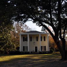
Felsenthal National Wildlife Refuge, National wildlife refuge in southern Arkansas, United States.

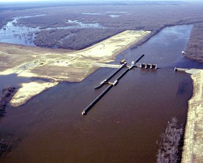
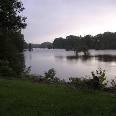
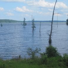
Felsenthal National Wildlife Refuge is a large protected area where the Saline and Ouachita Rivers meet, creating a landscape of wetlands, lakes, creeks, and forests. This diverse terrain supports numerous wildlife species and plant communities across its extensive grounds.

The refuge was established to replace wildlife habitats lost to a dam and river navigation project in the same region. This environmental compensation effort helped preserve an important ecosystem for future decades.

The archaeological remains scattered across the refuge show how Caddo peoples fished and settled in this region for generations. Visitors walking through the land can still sense the presence of these ancient communities in the landscape.

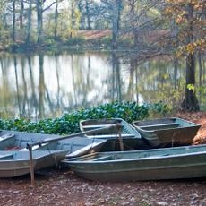
Visitors need to arrange access before arrival and can explore the refuge by boat, on foot, or from fishing spots along the water. The best time to visit depends on which wildlife and plants interest you and how much time you have to spend.

The refuge is home to a rare woodpecker species that is federally protected and nests in old trees throughout the area. Notably, the water level transforms dramatically with the seasons, flooding large portions of the landscape at certain times of year.

The community of curious travelers

AroundUs brings together thousands of curated places, local tips, and hidden gems, enriched daily by 60,000 contributors worldwide.

Start exploring
Location
Inception
1970
GPS coordinates
33.09040,-92.14180
Latest update
December 12, 2025 07:53
Around this place
Bayou Bartholomew
United States of America

Bayou Bartholomew

41.6 km
Chemin-A-Haut State Park
United States of America

Chemin-A-Haut State Park

34.2 km
Lake D'Arbonne State Park
United States of America

Lake D'Arbonne State Park

46.9 km
Lake D’Arbonne
United States of America

Lake D’Arbonne

45.1 km
First United Methodist Church
United States of America

First United Methodist Church

35.4 km
Dual State Monument
United States of America

Dual State Monument

22.9 km
Rialto Theatre
United States of America

Rialto Theatre

50.4 km
Griffin Auto Company Building
United States of America

Griffin Auto Company Building

50.3 km
Crossroads Fire Tower
United States of America

Crossroads Fire Tower

25.6 km
J.H. McWilliams House
United States of America

J.H. McWilliams House

50.4 km
El Dorado Apartments
United States of America

El Dorado Apartments

50 km
Joel Smith House
United States of America

Joel Smith House

46.5 km
Crossett Experimental Forest
United States of America

Crossett Experimental Forest

20 km
Rose Theatre
United States of America

Rose Theatre

40.8 km
Charles H. Murphy, Sr., House
United States of America

Charles H. Murphy, Sr., House

50.4 km
Henry Crawford McKinney House
United States of America

Henry Crawford McKinney House

50.2 km
Ouachita River Lock and Dam No. 8
United States of America

Ouachita River Lock and Dam No. 8

38.1 km
Watson House
United States of America

Watson House

35.8 km
First Presbyterian Church
United States of America

First Presbyterian Church

50.3 km
Newton House Museum
United States of America

Newton House Museum

50.4 km
Crossett Methodist Church
United States of America

Crossett Methodist Church

17.4 km
Morehouse Parish Courthouse
United States of America

Morehouse Parish Courthouse

40.8 km
Hamburg Commercial Historic District
United States of America

Hamburg Commercial Historic District

35.6 km
Crossett Municipal Building
United States of America

Crossett Municipal Building

17.3 km
Hamburg Presbyterian Church
United States of America

Hamburg Presbyterian Church

35.7 km
Adams-Leslie House
United States of America

Adams-Leslie House

48.1 km
W.R. Bunckley House
United States of America

W.R. Bunckley House

40.5 km
Smith-McCurry House
United States of America

Smith-McCurry House

44.3 km
Show the full map
« Felsenthal National Wildlife Refuge - National wildlife refuge in southern Arkansas, United States » is provided by Around Us (aroundus.com). Images and texts are derived from Wikimedia project under a Creative Commons license. You are allowed to copy, distribute, and modify copies of this page, under the conditions set by the license, as long as this note is clearly visible.

Discover hidden gems everywhere you go!

From secret cafés to breathtaking viewpoints, skip the crowded tourist spots and find places that match your style. Our app makes it easy with voice search, smart filtering, route optimization, and insider tips from travelers worldwide. Download now for the complete mobile experience.

Around Us App Screenshot

A unique approach to discovering new places

Le Figaro

All the places worth exploring

France Info

A tailor-made excursion in just a few clicks

20 Minutes

Around Us
Travel Guide & Maps
Download

Send to your phone

QR Code
1

Open the camera app on your mobile.

2

Point at the QR code with your camera. A notification will appear.

3

Tap the notification to open the link.