Enable Location

We need your location to show you interesting places around you

Discover nearby places

Find interesting locations and hidden gems around you

Precise directions

Get accurate directions and distances to places

Your location is never shared with other users. It's only used when you tap the location button.

Bayou Bartholomew

Log in to your account

Start exploring — it's free

Trusted by 63,319 travelers worldwide

Continue with Google
Continue with Apple
or

We will send you a code to connect

By continuing, you accept our Terms and Conditions and our Privacy Policy

Check your inbox

We've sent a pincode in your inbox. Please enter the code below.

Bayou Bartholomew
Discussion Reviews 1 Photos
17.8k Popularity

Bayou Bartholomew, 359-mile bayou between Louisiana and Arkansas, United States

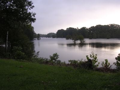
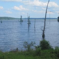
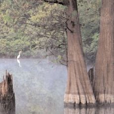
Bayou Bartholomew is a long waterway stretching between Louisiana and Arkansas, flowing through wetlands lined with cypress trees and swamp vegetation. The water supports many fish species and serves as home to alligators, turtles, birds, and other wildlife of the region.

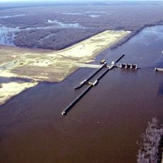
The waterway served early settlers as a vital route for trade and transportation through the Mississippi Delta region. This connection between communities enabled the exchange of goods and people across remote areas.

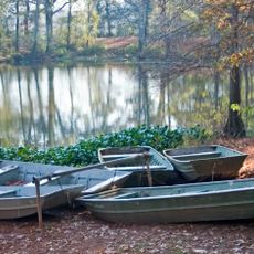
The communities here practice fishing methods rooted in multiple cultural traditions that you can still see in daily life along the water. People use techniques passed down through generations that shape how they relate to this waterway.

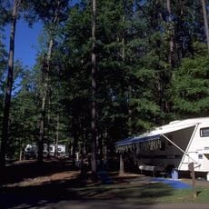
Several boat ramps provide access to the waterway for fishing and wildlife viewing activities. Expect wet conditions, insects, and changing water levels depending on the season.

The waterway experiences strong seasonal changes that create specialized habitats where rare fish and amphibian species breed and live. These shifting conditions support a diverse ecology that transforms throughout the year.

The community of curious travelers

AroundUs brings together thousands of curated places, local tips, and hidden gems, enriched daily by 60,000 contributors worldwide.

Start exploring
Location
Location
Elevation above the sea
18 m
GPS coordinates
32.72278,-92.06389
Latest update
December 7, 2025 19:23
Around this place
Watson Brake
United States of America

Watson Brake

40 km
JPS Field at Malone Stadium
United States of America

JPS Field at Malone Stadium

21.4 km
Chennault Aviation and Military Museum
United States of America

Chennault Aviation and Military Museum

23.5 km
Biedenharn Museum and Gardens
United States of America

Biedenharn Museum and Gardens

23.5 km
Felsenthal National Wildlife Refuge
United States of America

Felsenthal National Wildlife Refuge

41.6 km
Chemin-A-Haut State Park
United States of America

Chemin-A-Haut State Park

29.2 km
Jordan Mounds
United States of America

Jordan Mounds

29.8 km
Lake D'Arbonne State Park
United States of America

Lake D'Arbonne State Park

40.5 km
Lake D’Arbonne
United States of America

Lake D’Arbonne

34 km
D'Arbonne National Wildlife Refuge
United States of America

D'Arbonne National Wildlife Refuge

19.2 km
Masur Museum of Art
United States of America

Masur Museum of Art

26.6 km
Autrey House
United States of America

Autrey House

57.3 km
Dual State Monument
United States of America

Dual State Monument

42.9 km
Crossett Experimental Forest
United States of America

Crossett Experimental Forest

36.5 km
Rose Theatre
United States of America

Rose Theatre

15.3 km
First Presbyterian Church
United States of America

First Presbyterian Church

57.9 km
First United Methodist Church
United States of America

First United Methodist Church

25.5 km
Crossett Methodist Church
United States of America

Crossett Methodist Church

46.4 km
Crossett Municipal Auditorium
United States of America

Crossett Municipal Auditorium

48.2 km
Morehouse Parish Courthouse
United States of America

Morehouse Parish Courthouse

15.3 km
Boscobel Cottage
United States of America

Boscobel Cottage

48.3 km
Crossett Municipal Building
United States of America

Crossett Municipal Building

46.1 km
Vickers House
United States of America

Vickers House

44.9 km
Historic Biedenharn Home
United States of America

Historic Biedenharn Home

23.5 km
Northeast Louisiana Children's
United States of America

Northeast Louisiana Children's

24.9 km
Joy Theatre
United States of America

Joy Theatre

39.5 km
Mascur Museum
United States of America

Mascur Museum

26.3 km
African American Museum
United States of America

African American Museum

25.3 km
Show the full map
Reviews
Share your experience

No review yet

Discussions
Start a discussion...

No discussion yet

« Bayou Bartholomew - 359-mile bayou between Louisiana and Arkansas, United States » is provided by Around Us (aroundus.com). Images and texts are derived from Wikimedia project under a Creative Commons license. You are allowed to copy, distribute, and modify copies of this page, under the conditions set by the license, as long as this note is clearly visible.

Discover hidden gems everywhere you go!

From secret cafés to breathtaking viewpoints, skip the crowded tourist spots and find places that match your style. Our app makes it easy with voice search, smart filtering, route optimization, and insider tips from travelers worldwide. Download now for the complete mobile experience.

Around Us App Screenshot

A unique approach to discovering new places

Le Figaro

All the places worth exploring

France Info

A tailor-made excursion in just a few clicks

20 Minutes

Around Us
Travel Guide & Maps
Download

Send to your phone

QR Code
1

Open the camera app on your mobile.

2

Point at the QR code with your camera. A notification will appear.

3

Tap the notification to open the link.