Enable Location

We need your location to show you interesting places around you

Discover nearby places

Find interesting locations and hidden gems around you

Precise directions

Get accurate directions and distances to places

Your location is never shared with other users. It's only used when you tap the location button.

D'Arbonne National Wildlife Refuge

Log in to your account

Start exploring — it's free

Trusted by 61,371 travelers worldwide

Continue with Google
Continue with Apple
or

We will send you a code to connect

By continuing, you accept our Terms and Conditions and our Privacy Policy

Check your inbox

We've sent a pincode in your inbox. Please enter the code below.

D'Arbonne National Wildlife Refuge

D'Arbonne National Wildlife Refuge, Wildlife refuge with bottomland hardwood forest north of West Monroe, Louisiana.

Description

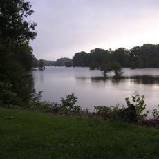
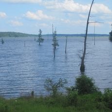
D'Arbonne National Wildlife Refuge is a protected area with swamp forests and bottomland hardwoods north of West Monroe, Louisiana. The land spans two parishes and contains cypress swamps, hardwood forests, and roughly 13 miles of bayou waterway.

History

The refuge was established in 1975 to protect bottomland forests and provide winter grounds for migrating waterfowl. Since then it has served as a critical stopover for birds traveling their annual routes.

Culture

The place serves as a space where visitors can watch migratory birds and native animals in their natural surroundings. People come here to experience how the bayou functions as a living system and to see creatures in their everyday habitat.

Practical

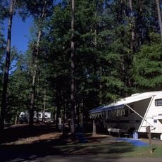
Seven access points with parking lots sit along Highway 143, making it easy for visitors to start activities like boating, fishing, hiking, or photography. The grounds are open to explore, with the best time for observing birds being from January to May.

Did you know?

During typical rainfall seasons, up to 87 percent of the refuge becomes wetland from January to May. This seasonal flooding creates ideal conditions for birds seeking rest and shelter, transforming the landscape into a pulsing cycle between water and forest.

Location
Inception
1986
GPS coordinates
32.60830,-92.21670
Latest update
December 14, 2025 13:02

AroundUs brings together thousands of curated places, local tips, and hidden gems, enriched daily by 60,000 contributors worldwide. Discover all places nearby (Louisiana).

Around this place
Watson Brake
United States of America

Watson Brake

27.9 km
Bayou Bartholomew
United States of America

Bayou Bartholomew

19.2 km
Joe Aillet Stadium
United States of America

Joe Aillet Stadium

42.1 km
JPS Field at Malone Stadium
United States of America

JPS Field at Malone Stadium

16.6 km
Chennault Aviation and Military Museum
United States of America

Chennault Aviation and Military Museum

18.6 km
Jimmie Davis State Park
United States of America

Jimmie Davis State Park

44.8 km
Biedenharn Museum and Gardens
United States of America

Biedenharn Museum and Gardens

12.7 km
Jordan Mounds
United States of America

Jordan Mounds

43 km
Lake D'Arbonne State Park
United States of America

Lake D'Arbonne State Park

32.4 km
Lake D’Arbonne
United States of America

Lake D’Arbonne

25.8 km
Masur Museum of Art
United States of America

Masur Museum of Art

16.7 km
Louisiana Tech University Arboretum
United States of America

Louisiana Tech University Arboretum

40.7 km
Dixie Center for the Arts
United States of America

Dixie Center for the Arts

40.5 km
Autrey House
United States of America

Autrey House

44.2 km
Dual State Monument
United States of America

Dual State Monument

47 km
Rose Theatre
United States of America

Rose Theatre

34.1 km
First Presbyterian Church
United States of America

First Presbyterian Church

40.4 km
First United Methodist Church
United States of America

First United Methodist Church

14.9 km
Morehouse Parish Courthouse
United States of America

Morehouse Parish Courthouse

34.1 km
Boscobel Cottage
United States of America

Boscobel Cottage

37.3 km
Federal Building
United States of America

Federal Building

40.5 km
Grambling State University Historic District
United States of America

Grambling State University Historic District

47.6 km
Vickers House
United States of America

Vickers House

43.5 km
Historic Biedenharn Home
United States of America

Historic Biedenharn Home

12.7 km
Northeast Louisiana Children's
United States of America

Northeast Louisiana Children's

14.7 km
Joy Theatre
United States of America

Joy Theatre

45.4 km
Mascur Museum
United States of America

Mascur Museum

16.4 km
African American Museum
United States of America

African American Museum

22.3 km
Show the full map
« D'Arbonne National Wildlife Refuge - Wildlife refuge with bottomland hardwood forest north of West Monroe, Louisiana » is provided by Around Us (aroundus.com). Images and texts are derived from Wikimedia project under a Creative Commons license. You are allowed to copy, distribute, and modify copies of this page, under the conditions set by the license, as long as this note is clearly visible.

Discover hidden gems everywhere you go!

From secret cafés to breathtaking viewpoints, skip the crowded tourist spots and find places that match your style. Our app makes it easy with voice search, smart filtering, route optimization, and insider tips from travelers worldwide. Download now for the complete mobile experience.

Around Us App Screenshot

A unique approach to discovering new places

Le Figaro

All the places worth exploring

France Info

A tailor-made excursion in just a few clicks

20 Minutes

Around Us
Travel Guide & Maps
Download

Send to your phone

QR Code
1

Open the camera app on your mobile.

2

Point at the QR code with your camera. A notification will appear.

3

Tap the notification to open the link.