Enable Location

We need your location to show you interesting places around you

Discover nearby places

Find interesting locations and hidden gems around you

Precise directions

Get accurate directions and distances to places

Your location is never shared with other users. It's only used when you tap the location button.

Chemin-A-Haut State Park

Log in to your account

Start exploring — it's free

Trusted by 63,312 travelers worldwide

Continue with Google
Continue with Apple
or

We will send you a code to connect

By continuing, you accept our Terms and Conditions and our Privacy Policy

Check your inbox

We've sent a pincode in your inbox. Please enter the code below.

Chemin-A-Haut State Park
Discussion Reviews 1 Photos
2.7k Popularity

Chemin-A-Haut State Park, State park in Morehouse Parish, Louisiana, US

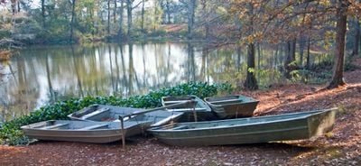
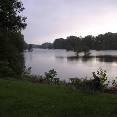
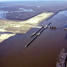
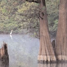
Chemin-A-Haut State Park covers about 503 acres of natural landscape in northern Louisiana positioned on elevated terrain overlooking the winding Bayou Bartholomew. The area includes walking trails, camping grounds, fishing access, and riding paths for visitors to explore.

The park entered the Louisiana State Park system in 1935 and took its name from French settlers in the area. They had named the elevated pathway after a route that Native Americans used for travel through the region.

The name means 'High Road' in French, a reminder of how early settlers referred to the elevated pathway through the region. Local people connect this place to the heritage of French exploration and settlement in Louisiana.

The park offers a swimming pool open from late May through early September, as well as year-round camping and picnic areas. Visitors will find the trails and riding paths accessible at most times, though conditions vary with weather and season.

Bayou Bartholomew, which runs along the park's edge, is one of North America's most fish-rich waterways. The waterway supports more than 115 different fish species, making it an exceptionally diverse ecosystem that sets it apart from many similar places.

The community of curious travelers

AroundUs brings together thousands of curated places, local tips, and hidden gems, enriched daily by 60,000 contributors worldwide.

Start exploring
Location
GPS coordinates
32.91000,-91.84500
Latest update
December 12, 2025 14:22
Around this place
Bayou Bartholomew
United States of America

Bayou Bartholomew

29.2 km
JPS Field at Malone Stadium
United States of America

JPS Field at Malone Stadium

47 km
Chennault Aviation and Military Museum
United States of America

Chennault Aviation and Military Museum

48.5 km
Felsenthal National Wildlife Refuge
United States of America

Felsenthal National Wildlife Refuge

34.2 km
Jordan Mounds
United States of America

Jordan Mounds

30.7 km
D'Arbonne National Wildlife Refuge
United States of America

D'Arbonne National Wildlife Refuge

48.4 km
Pugh House
United States of America

Pugh House

47.9 km
First United Methodist Church
United States of America

First United Methodist Church

35.3 km
Fiske Theatre
United States of America

Fiske Theatre

43.1 km
Dean House
United States of America

Dean House

48 km
Portland United Methodist Church
United States of America

Portland United Methodist Church

48.2 km
Crossroads Fire Tower
United States of America

Crossroads Fire Tower

36.5 km
Crossett Experimental Forest
United States of America

Crossett Experimental Forest

16.3 km
Rose Theatre
United States of America

Rose Theatre

16 km
Watson House
United States of America

Watson House

35.6 km
Crossett Methodist Church
United States of America

Crossett Methodist Church

26.9 km
Crossett Municipal Auditorium
United States of America

Crossett Municipal Auditorium

28.5 km
Morehouse Parish Courthouse
United States of America

Morehouse Parish Courthouse

16.1 km
Parkdale Methodist Church
United States of America

Parkdale Methodist Church

36.2 km
Parkdale Baptist Church-AS0051
United States of America

Parkdale Baptist Church-AS0051

36.4 km
Hamburg Commercial Historic District
United States of America

Hamburg Commercial Historic District

35.7 km
Crossett Municipal Building
United States of America

Crossett Municipal Building

26.6 km
Hamburg Presbyterian Church
United States of America

Hamburg Presbyterian Church

35.4 km
John P. Fisher House
United States of America

John P. Fisher House

46.5 km
Dr. M.C. Hawkins House
United States of America

Dr. M.C. Hawkins House

36.3 km
W.R. Bunckley House
United States of America

W.R. Bunckley House

36.3 km
Naff House
United States of America

Naff House

48.5 km
Watson-Sawyer House
United States of America

Watson-Sawyer House

35.2 km
Show the full map
Reviews
Share your experience

No review yet

Discussions
Start a discussion...

No discussion yet

« Chemin-A-Haut State Park - State park in Morehouse Parish, Louisiana, US » is provided by Around Us (aroundus.com). Images and texts are derived from Wikimedia project under a Creative Commons license. You are allowed to copy, distribute, and modify copies of this page, under the conditions set by the license, as long as this note is clearly visible.

Discover hidden gems everywhere you go!

From secret cafés to breathtaking viewpoints, skip the crowded tourist spots and find places that match your style. Our app makes it easy with voice search, smart filtering, route optimization, and insider tips from travelers worldwide. Download now for the complete mobile experience.

Around Us App Screenshot

A unique approach to discovering new places

Le Figaro

All the places worth exploring

France Info

A tailor-made excursion in just a few clicks

20 Minutes

Around Us
Travel Guide & Maps
Download

Send to your phone

QR Code
1

Open the camera app on your mobile.

2

Point at the QR code with your camera. A notification will appear.

3

Tap the notification to open the link.