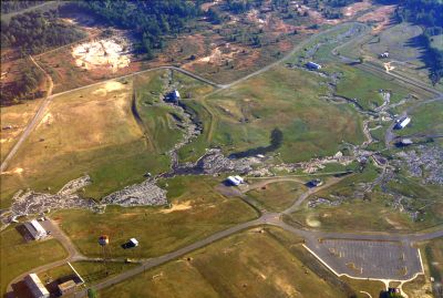
Mississippi River Basin Model, Scale model in Hinds County, United States.
The Mississippi River Basin Model is a massive scale representation in Hinds County that covers about 200 acres and depicts roughly 41 percent of United States territory. It displays a complex network of miniaturized rivers and waterways at different scales to replicate how water moves across the nation's river systems.
The project began in 1943 with the help of German and Italian prisoners of war who applied their technical knowledge to construct this vast hydraulic system. Their work resulted in one of the most sophisticated water simulation tools for studying river behavior across multiple states.
The model influenced flood control decisions across multiple states, preventing disasters and generating substantial cost savings through precise water flow predictions.
The model sits within Buddy Butts Park on McRaven Road and remains open to visitors, though the site is now overgrown with natural vegetation. Those planning a visit should expect to navigate an untamed landscape where nature has reclaimed much of the grounds.
Engineers designed the model with specific vertical and horizontal scale ratios—1:100 and 1:2000 respectively—to accurately simulate water movement across thousands of miles of waterways. This unusual combination of different scales was essential to achieving realistic water flow patterns.
The community of curious travelers
AroundUs brings together thousands of curated places, local tips, and hidden gems, enriched daily by 60,000 contributors worldwide.