Enable Location

We need your location to show you interesting places around you

Discover nearby places

Find interesting locations and hidden gems around you

Precise directions

Get accurate directions and distances to places

Your location is never shared with other users. It's only used when you tap the location button.

Lake Pontchartrain Causeway

Log in to your account

Start exploring — it's free

Trusted by 62,452 travelers worldwide

Continue with Google
Continue with Apple
or

We will send you a code to connect

By continuing, you accept our Terms and Conditions and our Privacy Policy

Check your inbox

We've sent a pincode in your inbox. Please enter the code below.

Lake Pontchartrain Causeway, Twin road bridge in Louisiana, United States.

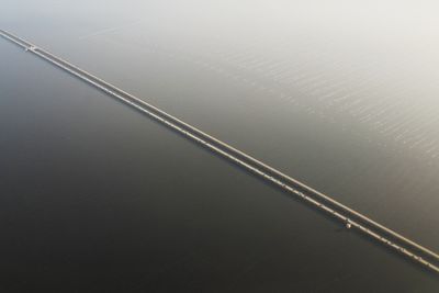
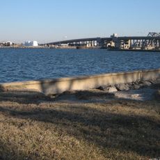
The Lake Pontchartrain Causeway consists of two parallel spans running 24 miles (38 km) across the lake, resting on thousands of reinforced concrete supports. Movable sections located about 8 miles (13 km) from the northern shore allow boats to pass and briefly interrupt the continuous roadway.

Planning started in the late 1940s after Louisiana legislators created a dedicated commission to oversee the project. The first two-lane span opened in 1956, followed by the second roadway in 1969.

The structure links two regions once separated by open water, making daily crossings between the shores a routine part of life. Drivers today experience a straight journey with the lake spreading out on both sides toward the horizon.

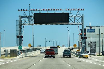
Crossing requires a toll collected on the south end near Metairie. Drivers heading in the opposite direction pay nothing.

For the longest stretch, land disappears completely from view on both sides, leaving drivers surrounded by water for several miles. First-time crossers often notice the feeling of floating above open water.

The community of curious travelers

AroundUs brings together thousands of curated places, local tips, and hidden gems, enriched daily by 60,000 contributors worldwide.

Start exploring
Location
Inception
August 30, 1956
Official opening
May 10, 1969
Made from material
reinforced concrete
GPS coordinates
30.19972,-90.12278
Latest update
December 14, 2025 19:02
Around this place
Seven Sisters Oak
United States of America

Seven Sisters Oak

18.8 km
United States of America

Pontchartrain Beach

19.6 km
Fontainebleau State Park
United States of America

Fontainebleau State Park

18.8 km
Spanish Fort
United States of America

Spanish Fort

20.1 km
Congregation Beth Israel
United States of America

Congregation Beth Israel

21.1 km
Big Branch Marsh National Wildlife Refuge
United States of America

Big Branch Marsh National Wildlife Refuge

17.7 km
United States of America

City Park Golf Courses

21.6 km
United States of America

Three Lakeway Center

20.4 km
Pass Manchac Light
United States of America

Pass Manchac Light

20 km
New Canal Light
United States of America

New Canal Light

19.2 km
Seabrook Bridge
United States of America

Seabrook Bridge

20.5 km
St. Frances Cabrini Church
United States of America

St. Frances Cabrini Church

21.2 km
Seabrook Railroad Bridge
United States of America

Seabrook Railroad Bridge

20.6 km
Dew Drop Social and Benevolent Hall
United States of America

Dew Drop Social and Benevolent Hall

18.3 km
United States of America

Southeast Louisiana National Wildlife Refuge Complex

17.7 km
Johnson House
United States of America

Johnson House

18.4 km
United States of America

Morel-Nott House

18.2 km
Bertus-Ducatel House
United States of America

Bertus-Ducatel House

17.7 km
New Canal Lighthouse
United States of America

New Canal Lighthouse

19.3 km
Tchefuncte River Range Rear Light
United States of America

Tchefuncte River Range Rear Light

20.4 km
United States of America

Lakeshore Playground

20.8 km
United States of America

Lakeshore Park

19.3 km
United States of America

Tchefuncte River Range Front Light

20.5 km
Milneberg Lighthouse
United States of America

Milneberg Lighthouse

19.5 km
Executive Tower One
United States of America

Executive Tower One

21.1 km
United States of America

City Park Golf Course

21.8 km

The Wild Osprey

18.6 km
United States of America

Collapsed Observarion Deck

17.5 km
Show the full map
« Lake Pontchartrain Causeway - Twin road bridge in Louisiana, United States » is provided by Around Us (aroundus.com). Images and texts are derived from Wikimedia project under a Creative Commons license. You are allowed to copy, distribute, and modify copies of this page, under the conditions set by the license, as long as this note is clearly visible.

Discover hidden gems everywhere you go!

From secret cafés to breathtaking viewpoints, skip the crowded tourist spots and find places that match your style. Our app makes it easy with voice search, smart filtering, route optimization, and insider tips from travelers worldwide. Download now for the complete mobile experience.

Around Us App Screenshot

A unique approach to discovering new places

Le Figaro

All the places worth exploring

France Info

A tailor-made excursion in just a few clicks

20 Minutes

Around Us
Travel Guide & Maps
Download

Send to your phone

QR Code
1

Open the camera app on your mobile.

2

Point at the QR code with your camera. A notification will appear.

3

Tap the notification to open the link.