Enable Location

We need your location to show you interesting places around you

Discover nearby places

Find interesting locations and hidden gems around you

Precise directions

Get accurate directions and distances to places

Your location is never shared with other users. It's only used when you tap the location button.

Yancopin Bridge

Log in to your account

Start exploring — it's free

Trusted by 62,441 travelers worldwide

Continue with Google
Continue with Apple
or

We will send you a code to connect

By continuing, you accept our Terms and Conditions and our Privacy Policy

Check your inbox

We've sent a pincode in your inbox. Please enter the code below.

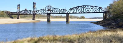
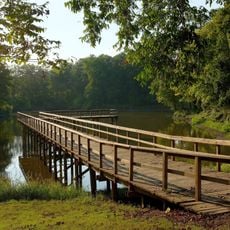
Yancopin Bridge, Railway and footbridge in Desha County, Arkansas.

Yancopin Bridge is a railway and footbridge across the Arkansas River in Desha County, Arkansas. The structure features two movable spans designed to allow river traffic to pass underneath.

The structure was built in 1903 by the Memphis, Helena & Louisiana Railway and proved essential during the 1927 Arkansas River flooding. Its movable spans were designed to adapt to changes in the river channel over time.

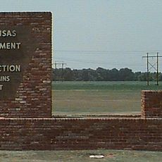
The bridge marks an important point in the region's transport history and now serves as a walking route for outdoor activities. Visitors can experience how a former railway crossing has become part of the local recreation network.

The structure is now part of the Delta Heritage Trail and maintained by the Arkansas State Highway and Transportation Department. Visitors can explore the area on foot with well-maintained pathways and open access throughout the site.

The structure combines a lift span with a swing span, a rare engineering solution that adapted to the river's changing conditions. This dual mechanism allowed it to handle both rail transport and river traffic simultaneously.

The community of curious travelers

AroundUs brings together thousands of curated places, local tips, and hidden gems, enriched daily by 60,000 contributors worldwide.

Start exploring
Location
GPS coordinates
33.95530,-91.20610
Latest update
December 13, 2025 11:40
Around this place
Cummins Unit
United States of America

Cummins Unit

36.5 km
United States of America

Varner Unit

38.3 km
Mississippi Alluvial Plain
United States of America

Mississippi Alluvial Plain

19.7 km
Arkansas Post
United States of America

Arkansas Post

14.6 km
Menard-Hodges Site
United States of America

Menard-Hodges Site

7 km
Hollywood
United States of America

Hollywood

39.8 km
Great River Road State Park
United States of America

Great River Road State Park

19.9 km
Tichnor Rice Dryer and Storage Building
United States of America

Tichnor Rice Dryer and Storage Building

21.1 km
Thane House
United States of America

Thane House

38.8 km
Arkansas County Courthouse-Southern District
United States of America

Arkansas County Courthouse-Southern District

39.6 km
A.M. Bohnert Rice Plantation Pump
United States of America

A.M. Bohnert Rice Plantation Pump

18.3 km
Grace Episcopal Church
United States of America

Grace Episcopal Church

19.9 km
Hubert & Ionia Furr House
United States of America

Hubert & Ionia Furr House

38.8 km
L.A. Black Rice Milling Association Inc. Office
United States of America

L.A. Black Rice Milling Association Inc. Office

39.3 km
Xenophon Overton Pindall Law Office
United States of America

Xenophon Overton Pindall Law Office

38.9 km
Arkansas City Commercial District
United States of America

Arkansas City Commercial District

39 km
Desha County Courthouse
United States of America

Desha County Courthouse

38.5 km
First United Methodist Church
United States of America

First United Methodist Church

39.7 km
DeWitt Commercial Historic District
United States of America

DeWitt Commercial Historic District

39.6 km
Taylor Log House and Site
United States of America

Taylor Log House and Site

38 km
Frank Tillar Memorial Methodist Episcopal Church, South
United States of America

Frank Tillar Memorial Methodist Episcopal Church, South

35.6 km
Dr. J.D. Watts House
United States of America

Dr. J.D. Watts House

27.6 km
Kemp Cotton Gin Historic District
United States of America

Kemp Cotton Gin Historic District

22.3 km
McKennon-Shea House
United States of America

McKennon-Shea House

27.7 km
Dickinson-Moore House
United States of America

Dickinson-Moore House

38.6 km
Arkansas Post National Memorial Visitor Center and Museum
United States of America

Arkansas Post National Memorial Visitor Center and Museum

14.5 km
Rohwer Relocation Center Memorial Cemetery
United States of America

Rohwer Relocation Center Memorial Cemetery

22.1 km
Rosedale Historic District
United States of America

Rosedale Historic District

19.7 km
Show the full map
« Yancopin Bridge - Railway and footbridge in Desha County, Arkansas » is provided by Around Us (aroundus.com). Images and texts are derived from Wikimedia project under a Creative Commons license. You are allowed to copy, distribute, and modify copies of this page, under the conditions set by the license, as long as this note is clearly visible.

Discover hidden gems everywhere you go!

From secret cafés to breathtaking viewpoints, skip the crowded tourist spots and find places that match your style. Our app makes it easy with voice search, smart filtering, route optimization, and insider tips from travelers worldwide. Download now for the complete mobile experience.

Around Us App Screenshot

A unique approach to discovering new places

Le Figaro

All the places worth exploring

France Info

A tailor-made excursion in just a few clicks

20 Minutes

Around Us
Travel Guide & Maps
Download

Send to your phone

QR Code
1

Open the camera app on your mobile.

2

Point at the QR code with your camera. A notification will appear.

3

Tap the notification to open the link.