Enable Location

We need your location to show you interesting places around you

Discover nearby places

Find interesting locations and hidden gems around you

Precise directions

Get accurate directions and distances to places

Your location is never shared with other users. It's only used when you tap the location button.

Dauphin Island Bridge

Log in to your account

Start exploring — it's free

Trusted by 62,443 travelers worldwide

Continue with Google
Continue with Apple
or

We will send you a code to connect

By continuing, you accept our Terms and Conditions and our Privacy Policy

Check your inbox

We've sent a pincode in your inbox. Please enter the code below.

Dauphin Island Bridge

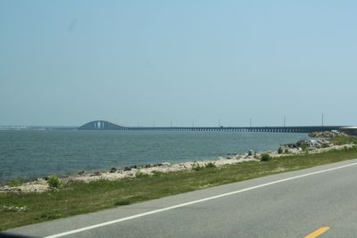
Dauphin Island Bridge, Road bridge in Mobile County, United States.

The Dauphin Island Bridge is a two-lane road crossing that spans the Gulf Intracoastal Waterway in Mobile County. It serves as the only direct road link connecting the mainland with Dauphin Island, making it essential for traffic between these two areas.

The original bridge was built in 1955 but was destroyed by Hurricane Frederic in 1979. The current structure was completed in 1982 as its replacement.

The bridge is named after Seth Gordon Persons, the 46th governor of Alabama, honoring his contributions to state government. Many travelers crossing it are unaware of this naming tribute.

The bridge forms part of Alabama State Route 193 and accommodates standard vehicle traffic. Visitors should be aware that this is the sole road access to the island, particularly important to consider during uncertain weather or planned maintenance work.

The construction employed precast concrete segments, a method that set new building standards for bridges of this scale in the region. This technique allowed for faster and more efficient assembly.

The community of curious travelers

AroundUs brings together thousands of curated places, local tips, and hidden gems, enriched daily by 60,000 contributors worldwide.

Start exploring
Location
Inception
1982
Official opening
1982
GPS coordinates
30.29210,-88.13000
Latest update
December 8, 2025 20:00
Around this place
Fort Morgan
United States of America

Fort Morgan

12.5 km
Bellingrath Gardens and Home
United States of America

Bellingrath Gardens and Home

15.4 km
Fort Gaines
United States of America

Fort Gaines

7.1 km
Sand Island Light
United States of America

Sand Island Light

13.9 km
Dauphin Island Sea Lab
United States of America

Dauphin Island Sea Lab

6.8 km
Bon Secour National Wildlife Refuge
United States of America

Bon Secour National Wildlife Refuge

30.4 km
Middle Bay Light
United States of America

Middle Bay Light

19.8 km
Tolstoy Park
United States of America

Tolstoy Park

37.1 km
Grand Bay National Wildlife Refuge
United States of America

Grand Bay National Wildlife Refuge

31 km
Dauphin Island Audubon Bird Sanctuary
United States of America

Dauphin Island Audubon Bird Sanctuary

6.2 km
Mobile Point Range Lights
United States of America

Mobile Point Range Lights

12.5 km
Martin Lindsey House
United States of America

Martin Lindsey House

35.7 km
St. Paul's Episcopal Church
United States of America

St. Paul's Episcopal Church

36.5 km
Montrose Historic District
United States of America

Montrose Historic District

37.8 km
Bishop Manor Estate
United States of America

Bishop Manor Estate

21.6 km
Horn Island Light
United States of America

Horn Island Light

35 km
East End Beach
United States of America

East End Beach

6.8 km
Grand Bay Historic District
United States of America

Grand Bay Historic District

28.9 km
Twin Beach AME Church
United States of America

Twin Beach AME Church

31.5 km
United States Post Office
United States of America

United States Post Office

33.6 km
Lebanon Chapel AME Church
United States of America

Lebanon Chapel AME Church

33.5 km
Sunnyside Hotel
United States of America

Sunnyside Hotel

36 km
Allen House
United States of America

Allen House

37.8 km
Street House
United States of America

Street House

29.4 km
Brunell House
United States of America

Brunell House

36 km
American Legion Post 199
United States of America

American Legion Post 199

31.9 km
Tolstoy Park, The Henry Stuart House
United States of America

Tolstoy Park, The Henry Stuart House

37.1 km
Dauphin Beach
United States of America

Dauphin Beach

5.6 km
Show the full map
« Dauphin Island Bridge - Road bridge in Mobile County, United States » is provided by Around Us (aroundus.com). Images and texts are derived from Wikimedia project under a Creative Commons license. You are allowed to copy, distribute, and modify copies of this page, under the conditions set by the license, as long as this note is clearly visible.

Discover hidden gems everywhere you go!

From secret cafés to breathtaking viewpoints, skip the crowded tourist spots and find places that match your style. Our app makes it easy with voice search, smart filtering, route optimization, and insider tips from travelers worldwide. Download now for the complete mobile experience.

Around Us App Screenshot

A unique approach to discovering new places

Le Figaro

All the places worth exploring

France Info

A tailor-made excursion in just a few clicks

20 Minutes

Around Us
Travel Guide & Maps
Download

Send to your phone

QR Code
1

Open the camera app on your mobile.

2

Point at the QR code with your camera. A notification will appear.

3

Tap the notification to open the link.