Tallahatchie County

Log in to your account

AroundUs is a community-driven map of interesting places, built by curious explorers like you. It grows with every review, story, and photo you share.
Connect to save your favorite spots, contribute locations, and create personalized routes.
Continue with Google
Continue with Apple
Continue with X
Continue with Facebook
Continue with email
By continuing, you accept our Terms and Conditions and our Privacy Policy
Create an account
Add to collection
Map
Suggest a change
Share

Tallahatchie County, Administrative division in Mississippi, United States.

Tallahatchie County is an administrative division of roughly 650 square miles in the Mississippi Delta through which the Tallahatchie River flows. The county operates with two separate seats of government: Charleston on the east and Sumner on the west.

The county was established in 1833 following the removal of the Choctaw people from the region and became historically significant during the American civil rights era. An important 1955 trial brought national attention and left a lasting mark on the county's place in broader historical events.

Communities here preserve local traditions through festivals and music events that showcase regional Mississippi Delta customs. These gatherings shape social life and reflect the cultural identity of the area.

The county is managed by a five-member Board of Supervisors operating from two different locations. Plan your visit with both administrative centers in mind depending on which area you want to explore or which services you need.

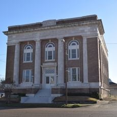
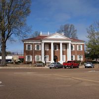
This county is one of the few in the United States that operates two completely separate administrative centers with their own courthouses. This unusual arrangement allows both communities to maintain their local independence and governance.

Location: Mississippi

Inception: December 31, 1833

Creator: William Eggleston

Capital city: Charleston

Shares border with: Quitman County, Leflore County, Panola County, Yalobusha County, Grenada County, Coahoma County, Sunflower County

GPS coordinates: 33.95000,-90.17000

Latest update: December 7, 2025 10:04

Photos
Around this place
Dockery Plantation
United States of America

Dockery Plantation

47.8 km
Ground Zero
United States of America

Ground Zero

46.5 km
Grenada Lake
United States of America

Grenada Lake

39.4 km
Delta Blues Museum
United States of America

Delta Blues Museum

46.5 km
Rice–Totten Field
United States of America

Rice–Totten Field

51.6 km
George P. Cossar State Park
United States of America

George P. Cossar State Park

33.3 km
Tallahatchie National Wildlife Refuge
United States of America

Tallahatchie National Wildlife Refuge

17.5 km
Tallahatchie County Second District Courthouse
United States of America

Tallahatchie County Second District Courthouse

18.5 km
Odd Fellows and Confederate Cemetery
United States of America

Odd Fellows and Confederate Cemetery

38.5 km
First Methodist Church of Greenwood
United States of America

First Methodist Church of Greenwood

48 km
Charley's Trace
United States of America

Charley's Trace

28.7 km
Grenada Masonic Temple
United States of America

Grenada Masonic Temple

38.7 km
Southworth House
United States of America

Southworth House

49.1 km
Lee House
United States of America

Lee House

44.9 km
Wesley Memorial Methodist Episcopal
United States of America

Wesley Memorial Methodist Episcopal

48.6 km
Emmett Till Interpretive Center
United States of America

Emmett Till Interpretive Center

18.6 km
Emmett Till Historic Intrepid Center - ETHIC
United States of America

Emmett Till Historic Intrepid Center - ETHIC

17.6 km
Evergreen Plantation
United States of America

Evergreen Plantation

32.7 km
Cotton Warehouse Classic Cars
United States of America

Cotton Warehouse Classic Cars

44 km
Delta Cinema
United States of America

Delta Cinema

46.7 km
Keesler Bridge
United States of America

Keesler Bridge

47.7 km
Batesville Historic District
United States of America

Batesville Historic District

45.4 km
Grenada Railway Yalobusha River Bridge
United States of America

Grenada Railway Yalobusha River Bridge

38.9 km
Downtown Grenada Historic District
United States of America

Downtown Grenada Historic District

38.6 km
Margin Street Historic District
United States of America

Margin Street Historic District

38.4 km
WROX Building
United States of America

WROX Building

46.6 km
Wesley Methodist Church Historic District
United States of America

Wesley Methodist Church Historic District

48.8 km
Dockery Farms
United States of America

Dockery Farms

48 km
Show the full map
Reviews

Visited this place? Tap the stars to rate it and share your experience / photos with the community! Try now! You can cancel it anytime.

Administrative divisions
« Tallahatchie County - Administrative division in Mississippi, United States » is provided by Around Us (aroundus.com). Images and texts are derived from Wikimedia project under a Creative Commons license. You are allowed to copy, distribute, and modify copies of this page, under the conditions set by the license, as long as this note is clearly visible.

Discover hidden gems everywhere you go!

From secret cafés to breathtaking viewpoints, skip the crowded tourist spots and find places that match your style. Our app makes it easy with voice search, smart filtering, route optimization, and insider tips from travelers worldwide. Download now for the complete mobile experience.

Around Us App Screenshot

A unique approach to discovering new places

Le Figaro

All the places worth exploring

France Info

A tailor-made excursion in just a few clicks

20 Minutes