Chest opened
+${chestReward.xp} XP
Explorer
NOUVEAU ×${chestReward.collectible.quantity}
tapez pour fermer
Chest locked

Open chests in the app

Around Us is built for your phone — chests unlock when you walk, explore and capture nearby places.

Enable Location

We need your location to show you interesting places around you

Discover nearby places

Find interesting locations and hidden gems around you

Precise directions

Get accurate directions and distances to places

Your location is never shared with other users. It's only used when you tap the location button.

Rio Hondo

Log in to your account

Start exploring — it's free

Trusted by 72,888 travelers worldwide

Continue with Google
Continue with Apple
or

We will send you a code to connect

By continuing, you accept our Terms and Conditions and our Privacy Policy

Check your inbox

We've sent a pincode in your inbox. Please enter the code below.

Rio Hondo
Discussion Reviews 1 Photos
11k Popularity

Rio Hondo, River tributary in Los Angeles County, California.

Rio Hondo is a river in Los Angeles County that flows southwest through suburban communities, running parallel to the San Gabriel River from Irwindale to South Gate. The waterway is managed through a system of dams and channels that help control flooding across the region.

The river is linked to a major military event: the Battle of Rio San Gabriel took place along these waters in 1847, marking a significant United States victory during the California conflict. The area was later incorporated into the flood control infrastructure of the rapidly developing Los Angeles County.

The Bosque del Rio Hondo Natural Area marks where the Repetto-Alvarado family once gathered, preserving the memory of the region's earlier inhabitants and their connection to the land. This protected space shows how the river shaped the lives of those who lived along its banks.

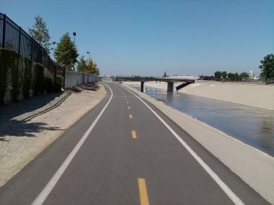
A paved trail system about 17 miles long connects several parks along the river, including Whittier Narrows Recreation Area, Crawford Park, and Veterans Memorial Park, offering spaces for walking and activities. The path is mostly flat and easy to access, making it suitable for different fitness levels.

The Whittier Narrows Dam has a special function: it can redirect water between Rio Hondo and the San Gabriel River during storms to distribute flood risk. This smart system remains invisible to most visitors, but it quietly protects surrounding communities from dangerous flooding.

The community of curious travelers

AroundUs brings together thousands of curated places, local tips, and hidden gems, enriched daily by 60,000 contributors worldwide.

Start exploring
GPS coordinates
33.93200,-118.17500
Latest update
December 8, 2025 13:43
Around this place
Watts Towers
United States of America

Watts Towers

6.1 km
Atchison, Topeka and Santa Fe Railway 3751
United States of America

Atchison, Topeka and Santa Fe Railway 3751

10.6 km
United States of America

Imperial Courts

5.4 km
United States of America

South Central Farm

10.5 km
Oldest McDonald's restaurant
United States of America

Oldest McDonald's restaurant

5.5 km
Dunbar Hotel
United States of America

Dunbar Hotel

11.2 km
Sears, Roebuck & Company Mail Order Building
United States of America

Sears, Roebuck & Company Mail Order Building

11 km
Johnie's Broiler
United States of America

Johnie's Broiler

3.1 km
Golden Gate Theater
United States of America

Golden Gate Theater

9.9 km
Armenian Genocide Martyrs Monument
United States of America

Armenian Genocide Martyrs Monument

11.5 km
Los Cerritos Ranch House
United States of America

Los Cerritos Ranch House

10.8 km
Dominguez Rancho Adobe
United States of America

Dominguez Rancho Adobe

8.2 km
Columbia Memorial Space Center
United States of America

Columbia Memorial Space Center

4.1 km
Golf N' Stuff
United States of America

Golf N' Stuff

6.4 km
Ralph J. Bunche House
United States of America

Ralph J. Bunche House

11.3 km
Leonie Pray House
United States of America

Leonie Pray House

11.1 km
52nd Place Historic District
United States of America

52nd Place Historic District

10.7 km
Punchbowl Formation
United States of America

Punchbowl Formation

7.9 km
United States of America

Shri Swaminarayan Mandir, Downey

4 km
Casa de Parley Johnson
United States of America

Casa de Parley Johnson

4.8 km
Prince Hall Masonic Temple
United States of America

Prince Hall Masonic Temple

10.5 km
Bethlehem Baptist Church
United States of America

Bethlehem Baptist Church

10 km
Golden State Mutual Life Insurance Building
United States of America

Golden State Mutual Life Insurance Building

11.1 km
Clarke Estate
United States of America

Clarke Estate

8.8 km
Robert Louis Stevenson Branch
United States of America

Robert Louis Stevenson Branch

10.9 km
Tomorrow's Aeronautical Museum
United States of America

Tomorrow's Aeronautical Museum

7.7 km
Aquatic Pavilion
United States of America

Aquatic Pavilion

10 km
Greater Whittier Regional Aquatic Center
United States of America

Greater Whittier Regional Aquatic Center

10 km
Show the full map
Reviews
Share your experience

No review yet

Discussions
Start a discussion...

No discussion yet

« Rio Hondo - River tributary in Los Angeles County, California » is provided by Around Us (aroundus.com). Images and texts are derived from Wikimedia project under a Creative Commons license. You are allowed to copy, distribute, and modify copies of this page, under the conditions set by the license, as long as this note is clearly visible.

Discover hidden gems everywhere you go!

From secret cafés to breathtaking viewpoints, skip the crowded tourist spots and find places that match your style. Our app makes it easy with voice search, smart filtering, route optimization, and insider tips from travelers worldwide. Download now for the complete mobile experience.

Around Us App Screenshot

A unique approach to discovering new places

Le Figaro

All the places worth exploring

France Info

A tailor-made excursion in just a few clicks

20 Minutes

Around Us
Travel Guide & Maps
Download

Send to your phone

QR Code
1

Open the camera app on your mobile.

2

Point at the QR code with your camera. A notification will appear.

3

Tap the notification to open the link.