Enable Location

We need your location to show you interesting places around you

Discover nearby places

Find interesting locations and hidden gems around you

Precise directions

Get accurate directions and distances to places

Your location is never shared with other users. It's only used when you tap the location button.

52nd Place Historic District

Log in to your account

Start exploring — it's free

Trusted by 63,019 travelers worldwide

Continue with Google
Continue with Apple
or

We will send you a code to connect

By continuing, you accept our Terms and Conditions and our Privacy Policy

Check your inbox

We've sent a pincode in your inbox. Please enter the code below.

Discussion Reviews 1 Photos
2.1k Popularity

52nd Place Historic District, Historic district in South Los Angeles, United States

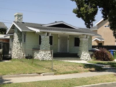
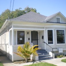
The 52nd Place Historic District is a residential area in South Los Angeles containing 37 one-story Craftsman houses built between 1911 and 1914. Each building features signature elements such as gabled roofs, overhanging eaves, and brick chimneys that define the neighborhood's character.

The district was established in the early 1910s as an affluent white neighborhood with newly built single-family homes. During the Great Migration in the 1930s, African Americans moved into the area in increasing numbers, fundamentally shifting the neighborhood's demographic and social composition.

The houses display Craftsman design elements with their characteristic overhanging eaves and front porches, which shaped how residents lived and interacted with their neighbors. This architectural style created outdoor spaces where the community naturally gathered and spent time together.

The district runs along 52nd Place between McKinley Avenue and Avalon Boulevard and is easy to navigate on foot. The homes sit closely together, allowing visitors to view the architecture and style from different angles as they explore the neighborhood.

The district was home to prominent figures in the African American community, including jazz singer Ivie Anderson and media entrepreneur and activist Joseph Bass. These residents contributed to the cultural and political movements of their era through their work and commitment.

The community of curious travelers

AroundUs brings together thousands of curated places, local tips, and hidden gems, enriched daily by 60,000 contributors worldwide.

Start exploring
Location
GPS coordinates
33.99472,-118.26278
Latest update
December 14, 2025 09:45
Around this place
Los Angeles Memorial Coliseum
United States of America

Los Angeles Memorial Coliseum

3.2 km
Wrigley Field
United States of America

Wrigley Field

1.5 km
California Science Center
United States of America

California Science Center

3.2 km
Natural History Museum Los Angeles County
United States of America

Natural History Museum Los Angeles County

3.5 km
Galen Center
United States of America

Galen Center

3.4 km
Exposition Park
United States of America

Exposition Park

3.2 km
United States of America

South Central Farm

2.5 km
King Estates
United States of America

King Estates

3 km
California African American Museum
United States of America

California African American Museum

3 km
Exposition Park Rose Garden
United States of America

Exposition Park Rose Garden

3.2 km
28th Street YMCA
United States of America

28th Street YMCA

2.5 km
Wallis Annenberg Building
United States of America

Wallis Annenberg Building

3 km
USC Fisher Museum of Art
United States of America

USC Fisher Museum of Art

3.5 km
27th Street Historic District
United States of America

27th Street Historic District

2.7 km
Campus of the University of Southern California
United States of America

Campus of the University of Southern California

3.5 km
Ralph J. Bunche House
United States of America

Ralph J. Bunche House

2 km
Lincoln Theatre
United States of America

Lincoln Theatre

3 km
Zumberge Hall
United States of America

Zumberge Hall

3.5 km
Space Shuttle Endeavour
United States of America

Space Shuttle Endeavour

3.1 km
Roosevelt Building
United States of America

Roosevelt Building

2.6 km
Prince Hall Masonic Temple
United States of America

Prince Hall Masonic Temple

591 m
Bethlehem Baptist Church
United States of America

Bethlehem Baptist Church

1.4 km
Widney Hall
United States of America

Widney Hall

3.3 km
Leavey Library
United States of America

Leavey Library

3.5 km
Golden State Mutual Life Insurance Building
United States of America

Golden State Mutual Life Insurance Building

1.4 km
Vermont Square Branch
United States of America

Vermont Square Branch

3 km
John Muir Branch Library
United States of America

John Muir Branch Library

3.1 km
Moneta Branch
United States of America

Moneta Branch

1.9 km
Show the full map
Reviews
Share your experience

No review yet

Discussions
Start a discussion...

No discussion yet

« 52nd Place Historic District - Historic district in South Los Angeles, United States » is provided by Around Us (aroundus.com). Images and texts are derived from Wikimedia project under a Creative Commons license. You are allowed to copy, distribute, and modify copies of this page, under the conditions set by the license, as long as this note is clearly visible.

Discover hidden gems everywhere you go!

From secret cafés to breathtaking viewpoints, skip the crowded tourist spots and find places that match your style. Our app makes it easy with voice search, smart filtering, route optimization, and insider tips from travelers worldwide. Download now for the complete mobile experience.

Around Us App Screenshot

A unique approach to discovering new places

Le Figaro

All the places worth exploring

France Info

A tailor-made excursion in just a few clicks

20 Minutes

Around Us
Travel Guide & Maps
Download

Send to your phone

QR Code
1

Open the camera app on your mobile.

2

Point at the QR code with your camera. A notification will appear.

3

Tap the notification to open the link.