Baldwin Hills Reservoir

Log in to your account

AroundUs is a community-driven map of interesting places, built by curious explorers like you. It grows with every review, story, and photo you share.
Connect to save your favorite spots, contribute locations, and create personalized routes.
Continue with Google
Continue with Apple
Continue with X
Continue with Facebook
Continue with email
By continuing, you accept our Terms and Conditions and our Privacy Policy
Create an account
Add to collection
Map
Suggest a change
Share

Baldwin Hills Reservoir, Water reservoir in Baldwin Hills, Los Angeles, United States.

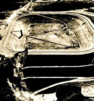
Baldwin Hills Reservoir was a water storage facility in Baldwin Hills, Los Angeles, built at an elevation of 232 feet (71 meters) with earth dikes on three sides and a main dam to the north. The structure covered several acres and held enough water to serve part of the city's supply until the dam failed and the site was permanently taken out of service.

The project started in 1951 through the city water department to meet growing drinking water demand in Los Angeles. On December 14, 1963, the dam collapsed completely within 77 minutes, leading to one of the most consequential dam failures in California history.

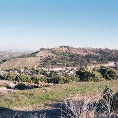
The spot recalls one of the city's most serious infrastructure accidents, with visitors today using hiking trails that cross the former basin site. Interpretive signs at the edge of the park tell the story, while joggers and cyclists move through the hills without noticing the ground's earlier purpose.

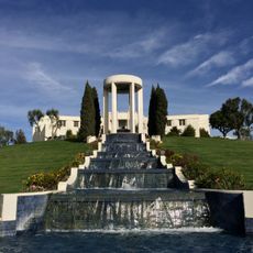
The remains lie within Kenneth Hahn State Recreation Area, so visitors can use the park's hills and paths to trace the topography of the former basin. A visit on weekdays avoids larger crowds, while viewpoints in the park offer a look at the surrounding area.

Engineers later discovered a crack in the dam structure caused by underground oil extraction that led to the sudden failure. The incident influenced nationwide regulations for dam construction in areas with active oil drilling.

Location: California

GPS coordinates: 34.00820,-118.36400

Latest update: December 5, 2025 22:29

Photos
Around this place
Hillside Memorial Park
United States of America

Hillside Memorial Park

3.9 km
Museum of Jurassic Technology
United States of America

Museum of Jurassic Technology

3.5 km
Kenneth Hahn State Recreation Area
United States of America

Kenneth Hahn State Recreation Area

102 m
Culver Hotel
United States of America

Culver Hotel

3.3 km
William Andrews Clark Memorial Library
United States of America

William Andrews Clark Memorial Library

5.4 km
Jeff's Gourmet Sausage Factory
United States of America

Jeff's Gourmet Sausage Factory

5.6 km
Centinela Adobe
United States of America

Centinela Adobe

4.6 km
Wende Museum
United States of America

Wende Museum

2.6 km
King Fahad Mosque
United States of America

King Fahad Mosque

4.3 km
Holiday Bowl
United States of America

Holiday Bowl

2.9 km
Bhagavad-gita Museum
United States of America

Bhagavad-gita Museum

3.6 km
Westminster Presbyterian Church
United States of America

Westminster Presbyterian Church

4.5 km
United States of America

Centinela Springs

4.2 km
Ivy Substation
United States of America

Ivy Substation

3.3 km
Eugene W. Britt House
United States of America

Eugene W. Britt House

5.5 km
Washington Irving Branch
United States of America

Washington Irving Branch

4.8 km
Paul R. Williams Residence
United States of America

Paul R. Williams Residence

4.9 km
St. Mark Coptic Orthodox Church
United States of America

St. Mark Coptic Orthodox Church

5 km
Holmes-Shannon House
United States of America

Holmes-Shannon House

5.4 km
Memorial Branch
United States of America

Memorial Branch

5.7 km
Fox Theatre
United States of America

Fox Theatre

5.1 km
Angeles Mesa Branch
United States of America

Angeles Mesa Branch

4.5 km
Walter Maciel Gallery
United States of America

Walter Maciel Gallery

3.1 km
Jefferson Branch
United States of America

Jefferson Branch

4.6 km
Citizens Publishing Company Building
United States of America

Citizens Publishing Company Building

3.3 km
Sony Pictures Plaza
United States of America

Sony Pictures Plaza

3.4 km
Samitaur Tower
United States of America

Samitaur Tower

2.6 km
Hidden History Museum
United States of America

Hidden History Museum

4.6 km
Show the full map
Reviews

Visited this place? Tap the stars to rate it and share your experience / photos with the community! Try now! You can cancel it anytime.

« Baldwin Hills Reservoir - Water reservoir in Baldwin Hills, Los Angeles, United States » is provided by Around Us (aroundus.com). Images and texts are derived from Wikimedia project under a Creative Commons license. You are allowed to copy, distribute, and modify copies of this page, under the conditions set by the license, as long as this note is clearly visible.

Discover hidden gems everywhere you go!

From secret cafés to breathtaking viewpoints, skip the crowded tourist spots and find places that match your style. Our app makes it easy with voice search, smart filtering, route optimization, and insider tips from travelers worldwide. Download now for the complete mobile experience.

Around Us App Screenshot

A unique approach to discovering new places

Le Figaro

All the places worth exploring

France Info

A tailor-made excursion in just a few clicks

20 Minutes