Chest opened
+${chestReward.xp} XP
Explorer
NOUVEAU ×${chestReward.collectible.quantity}
tapez pour fermer
Chest locked

Open chests in the app

Around Us is built for your phone — chests unlock when you walk, explore and capture nearby places.

Enable Location

We need your location to show you interesting places around you

Discover nearby places

Find interesting locations and hidden gems around you

Precise directions

Get accurate directions and distances to places

Your location is never shared with other users. It's only used when you tap the location button.

Ocmulgee River

Log in to your account

Start exploring — it's free

Trusted by 72,887 travelers worldwide

Continue with Google
Continue with Apple
or

We will send you a code to connect

By continuing, you accept our Terms and Conditions and our Privacy Policy

Check your inbox

We've sent a pincode in your inbox. Please enter the code below.

Ocmulgee River
Discussion Reviews 1 Photos
17.4k Popularity

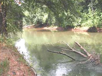
Ocmulgee River, River system in central Georgia, United States

The Ocmulgee River is a river system in central Georgia formed by the meeting of three major waterways that flow eastward across the region. It continues until it merges with another major river, creating an important water corridor through the lowlands.

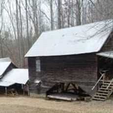
The river has been home to human settlements for thousands of years, with evidence of occupation dating back very far into the past. European explorers in the 1500s encountered Native American communities still living along its banks when they passed through.

The river has long served as a gathering place for Native American peoples who depended on its waters and resources for their way of life. Today, visitors can observe the earthen mounds and other physical remains that mark where these communities once thrived.

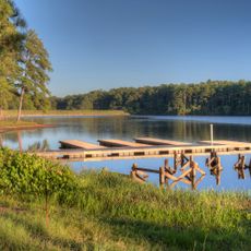
The river system can be explored in several ways, from walking along the banks to paddling on the water itself during appropriate times. Spring and fall are generally good seasons to visit when water levels are manageable and weather is mild.

The river system contains fish species found nowhere else in the world, making it a place of special ecological value. These rare forms of fish life have adapted specifically to these waters over many generations.

The community of curious travelers

AroundUs brings together thousands of curated places, local tips, and hidden gems, enriched daily by 60,000 contributors worldwide.

Start exploring
Location
GPS coordinates
33.32083,-83.84417
Latest update
December 7, 2025 19:24
Around this place
Monastery of the Holy Spirit
United States of America

Monastery of the Holy Spirit

36 km
Indian Springs State Park
United States of America

Indian Springs State Park

11 km
Jarrell Plantation State Historic Site
United States of America

Jarrell Plantation State Historic Site

31.9 km
Dauset Trails Nature Center
United States of America

Dauset Trails Nature Center

13.4 km
Newton County Courthouse
United States of America

Newton County Courthouse

30.8 km
McDonough Historic District
United States of America

McDonough Historic District

31.5 km
Orna Villa
United States of America

Orna Villa

33.7 km
Monticello High School
United States of America

Monticello High School

14.7 km
Locust Grove Institute
United States of America

Locust Grove Institute

25.3 km
Butts County Courthouse
United States of America

Butts County Courthouse

11.8 km
Oxford Historic District
United States of America

Oxford Historic District

33.8 km
Henry County Courthouse
United States of America

Henry County Courthouse

31.5 km
Pritchard-Moore-Goodrich House
United States of America

Pritchard-Moore-Goodrich House

39.9 km
Sam Bailey Building
United States of America

Sam Bailey Building

39.5 km
Idlewilde
United States of America

Idlewilde

11 km
Double Cabins
United States of America

Double Cabins

32.6 km
Globe Hotel
United States of America

Globe Hotel

31.6 km
Brown House
United States of America

Brown House

31.4 km
J. R. Carmichael House
United States of America

J. R. Carmichael House

12.1 km
Griffin Commercial Historic District
United States of America

Griffin Commercial Historic District

39.9 km
Jasper County Courthouse
United States of America

Jasper County Courthouse

15 km
Monroe County Courthouse
United States of America

Monroe County Courthouse

33.1 km
Locust Grove Historic District
United States of America

Locust Grove Historic District

24.9 km
Cabaniss-Hanberry House
United States of America

Cabaniss-Hanberry House

36.8 km
Forsyth Commercial Historic District
United States of America

Forsyth Commercial Historic District

32.9 km
Herman and Allene Shaver House
United States of America

Herman and Allene Shaver House

36.6 km
Old Spalding County Courthouse
United States of America

Old Spalding County Courthouse

39.6 km
Mills House
United States of America

Mills House

39.7 km
Show the full map
Reviews
Share your experience

No review yet

Discussions
Start a discussion...

No discussion yet

« Ocmulgee River - River system in central Georgia, United States » is provided by Around Us (aroundus.com). Images and texts are derived from Wikimedia project under a Creative Commons license. You are allowed to copy, distribute, and modify copies of this page, under the conditions set by the license, as long as this note is clearly visible.

Discover hidden gems everywhere you go!

From secret cafés to breathtaking viewpoints, skip the crowded tourist spots and find places that match your style. Our app makes it easy with voice search, smart filtering, route optimization, and insider tips from travelers worldwide. Download now for the complete mobile experience.

Around Us App Screenshot

A unique approach to discovering new places

Le Figaro

All the places worth exploring

France Info

A tailor-made excursion in just a few clicks

20 Minutes

Around Us
Travel Guide & Maps
Download

Send to your phone

QR Code
1

Open the camera app on your mobile.

2

Point at the QR code with your camera. A notification will appear.

3

Tap the notification to open the link.