Enable Location

We need your location to show you interesting places around you

Discover nearby places

Find interesting locations and hidden gems around you

Precise directions

Get accurate directions and distances to places

Your location is never shared with other users. It's only used when you tap the location button.

Monticello High School

Log in to your account

Start exploring — it's free

Trusted by 62,596 travelers worldwide

Continue with Google
Continue with Apple
or

We will send you a code to connect

By continuing, you accept our Terms and Conditions and our Privacy Policy

Check your inbox

We've sent a pincode in your inbox. Please enter the code below.

Monticello High School, high school in Monticello, Georgia, United States

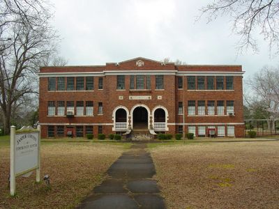
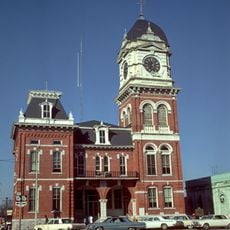
Monticello High School is a three-story brick building in downtown Monticello, Georgia, built in 1922 and shaped like the letter T. It stands on a spacious site along College Street and was designed by architect Henry Hunter Jordan with a balanced, orderly appearance.

The school was built in 1922 and served as the county's first school to educate students from all parts of Jasper County. It was added to the National Register of Historic Places in 1978, marking its importance to local educational history.

The school is now known as Thomas Persons Hall, a name rooted in local history. It serves as a gathering place for community events and remains central to how residents connect with their town's traditions.

The school is centrally located on College Street in Monticello and is easy to reach on foot or by car. The building remains largely in its original condition from the outside, making it straightforward to spot when walking through town.

The building was designed with large windows by architect Henry Hunter Jordan to bring abundant natural light into classrooms. This design feature reveals how educators in the early 1900s thought about learning spaces.

The community of curious travelers

AroundUs brings together thousands of curated places, local tips, and hidden gems, enriched daily by 60,000 contributors worldwide.

Start exploring
Location
GPS coordinates
33.30690,-83.68750
Latest update
February 9, 2026 07:46
Around this place
Georgia in the American Civil War

Georgia in the American Civil War

38.4 km
Georgia Diagnostic and Classification State Prison
United States of America

Georgia Diagnostic and Classification State Prison

36 km
Rock Eagle Effigy Mound
United States of America

Rock Eagle Effigy Mound

30.4 km
Indian Springs State Park
United States of America

Indian Springs State Park

22.9 km
Jarrell Plantation State Historic Site
United States of America

Jarrell Plantation State Historic Site

28.5 km
The Bruce Weiner Microcar Museum
United States of America

The Bruce Weiner Microcar Museum

33.5 km
Dauset Trails Nature Center
United States of America

Dauset Trails Nature Center

25.3 km
Madison Historic District
United States of America

Madison Historic District

37.7 km
Newton County Courthouse
United States of America

Newton County Courthouse

36.1 km
Jones County High School
United States of America

Jones County High School

36.1 km
Orna Villa
United States of America

Orna Villa

39 km
Carter-Newton House
United States of America

Carter-Newton House

37.3 km
Butts County Courthouse
United States of America

Butts County Courthouse

26 km
Oxford Historic District
United States of America

Oxford Historic District

39.2 km
Morgan County Courthouse
United States of America

Morgan County Courthouse

38.2 km
Idlewilde
United States of America

Idlewilde

22.9 km
J. R. Carmichael House
United States of America

J. R. Carmichael House

26.4 km
Jasper County Courthouse
United States of America

Jasper County Courthouse

436 m
Monroe County Courthouse
United States of America

Monroe County Courthouse

38.3 km
Locust Grove Historic District
United States of America

Locust Grove Historic District

39.5 km
Terrell-Sadler House
United States of America

Terrell-Sadler House

32.5 km
Cabaniss-Hanberry House
United States of America

Cabaniss-Hanberry House

26.5 km
Forsyth Commercial Historic District
United States of America

Forsyth Commercial Historic District

38.2 km
Herman and Allene Shaver House
United States of America

Herman and Allene Shaver House

28.6 km
Jones County Courthouse
United States of America

Jones County Courthouse

36.1 km
Eatonton Historic District
United States of America

Eatonton Historic District

27.8 km
Roberts-Bush-Roberts House
United States of America

Roberts-Bush-Roberts House

35.6 km
Rose Theater
United States of America

Rose Theater

38.3 km
Show the full map
« Monticello High School - high school in Monticello, Georgia, United States » is provided by Around Us (aroundus.com). Images and texts are derived from Wikimedia project under a Creative Commons license. You are allowed to copy, distribute, and modify copies of this page, under the conditions set by the license, as long as this note is clearly visible.

Discover hidden gems everywhere you go!

From secret cafés to breathtaking viewpoints, skip the crowded tourist spots and find places that match your style. Our app makes it easy with voice search, smart filtering, route optimization, and insider tips from travelers worldwide. Download now for the complete mobile experience.

Around Us App Screenshot

A unique approach to discovering new places

Le Figaro

All the places worth exploring

France Info

A tailor-made excursion in just a few clicks

20 Minutes

Around Us
Travel Guide & Maps
Download

Send to your phone

QR Code
1

Open the camera app on your mobile.

2

Point at the QR code with your camera. A notification will appear.

3

Tap the notification to open the link.