·

Enable Location

We need your location to show you interesting places around you

Discover nearby places

Find interesting locations and hidden gems around you

Precise directions

Get accurate directions and distances to places

Your location is never shared with other users. It's only used when you tap the location button.

Log in to your account

Start exploring — it's free

Trusted by 62,690 travelers worldwide

Continue with Google
Continue with Apple
or

We will send you a code to connect

By continuing, you accept our Terms and Conditions and our Privacy Policy

Check your inbox

We've sent a pincode in your inbox. Please enter the code below.

Mountain Longleaf National Wildlife Refuge

Mountain Longleaf National Wildlife Refuge, National wildlife refuge in Calhoun County, Alabama, US.

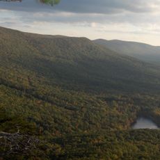
Mountain Longleaf National Wildlife Refuge is a protected area in northeastern Alabama that spans over 9,000 acres of forested mountain slopes. The landscape is dominated by longleaf pine forests growing at elevations around 1,400 feet, with hiking trails and observation points distributed throughout the accessible portions.

The refuge was established in 2003 on former military training grounds, converting the Fort McClellan site into a protected landscape. This transformation allowed the region to preserve one of the last remaining natural longleaf pine ecosystems in the southeastern United States.

The refuge provides educational programs about the longleaf pine ecosystem, engaging local communities through guided tours and research opportunities for scientists and students.

Visitors can access roughly 3,000 acres of the refuge during daylight hours, with marked hiking trails and viewing points spread throughout the open areas. Walking slowly through the forest increases your chances of spotting wildlife in their natural habitat.

The refuge shelters several endangered animals, including red-cockaded woodpeckers and gray bats, species that have become scarce in other regions. These fragile populations depend on this protected forest for their survival.

The community of curious travelers

AroundUs brings together thousands of curated places, local tips, and hidden gems, enriched daily by 60,000 contributors worldwide.

Start exploring
Location
Inception
2003
Elevation above the sea
430 m
GPS coordinates
33.69680,-85.75190
Latest update
December 11, 2025 11:07
Around this place
Cheaha Mountain
United States of America

Cheaha Mountain

24.1 km
JSU Stadium
United States of America

JSU Stadium

13.8 km
Coldwater Covered Bridge
United States of America

Coldwater Covered Bridge

11.6 km
Anniston Museum of Natural History
United States of America

Anniston Museum of Natural History

6.3 km
Shoal Creek Church
United States of America

Shoal Creek Church

19.5 km
Parker Memorial Baptist Church
United States of America

Parker Memorial Baptist Church

8 km
St. Michael and All Angels Episcopal Church
United States of America

St. Michael and All Angels Episcopal Church

9.1 km
Samuel Noble Monument
United States of America

Samuel Noble Monument

8.2 km
Grace Episcopal Church
United States of America

Grace Episcopal Church

8.1 km
Temple Beth-El
United States of America

Temple Beth-El

7.9 km
John Morgan House
United States of America

John Morgan House

16.3 km
Saint Paul's Methodist Episcopal Church
United States of America

Saint Paul's Methodist Episcopal Church

7.8 km
Mount Zion Baptist Church
United States of America

Mount Zion Baptist Church

9.4 km
Calhoun County Courthouse
United States of America

Calhoun County Courthouse

8.5 km
Ross Creek Bridge
United States of America

Ross Creek Bridge

18.2 km
Ten Oaks
United States of America

Ten Oaks

12.5 km
Aderholdt's Mill
United States of America

Aderholdt's Mill

9.4 km
Davis C. Cooper House
United States of America

Davis C. Cooper House

11.7 km
Dudley Snow House
United States of America

Dudley Snow House

13.8 km
First Presbyterian Church
United States of America

First Presbyterian Church

13.4 km
Union Depot and Freight House
United States of America

Union Depot and Freight House

8.6 km
Kilby House
United States of America

Kilby House

7.5 km
Alexander Woods House
United States of America

Alexander Woods House

13.8 km
Richard P. Huger House
United States of America

Richard P. Huger House

7.7 km
McKleroy-Wilson-Kirby House
United States of America

McKleroy-Wilson-Kirby House

7.8 km
Crowan Cottage
United States of America

Crowan Cottage

7.4 km
Bank of Anniston
United States of America

Bank of Anniston

8.4 km
Cleburne County Courthouse
United States of America

Cleburne County Courthouse

16.1 km
Show the full map
« Mountain Longleaf National Wildlife Refuge - National wildlife refuge in Calhoun County, Alabama, US » is provided by Around Us (aroundus.com). Images and texts are derived from Wikimedia project under a Creative Commons license. You are allowed to copy, distribute, and modify copies of this page, under the conditions set by the license, as long as this note is clearly visible.

Discover hidden gems everywhere you go!

From secret cafés to breathtaking viewpoints, skip the crowded tourist spots and find places that match your style. Our app makes it easy with voice search, smart filtering, route optimization, and insider tips from travelers worldwide. Download now for the complete mobile experience.

Around Us App Screenshot

A unique approach to discovering new places

Le Figaro

All the places worth exploring

France Info

A tailor-made excursion in just a few clicks

20 Minutes

Around Us
Travel Guide & Maps
Download

Send to your phone

QR Code
1

Open the camera app on your mobile.

2

Point at the QR code with your camera. A notification will appear.

3

Tap the notification to open the link.