Igbo Landing Historic Site

Log in to your account

AroundUs is a community-driven map of interesting places, built by curious explorers like you. It grows with every review, story, and photo you share.
Connect to save your favorite spots, contribute locations, and create personalized routes.
By continuing, you accept our Terms and Conditions and our Privacy Policy

Igbo Landing Historic Site

Add to collection
Map
Suggest a change
Share

Igbo Landing Historic Site, Historic site at Dunbar Creek, Saint Simons Island, United States.

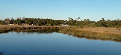
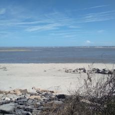
Igbo Landing Historic Site is a memorial location on Dunbar Creek at Saint Simons Island in the United States, commemorating a tragic event from 1803. A marker near the shore identifies the spot where enslaved people from West Africa arrived and resisted their oppression.

In 1803, a group of around 75 enslaved Igbo from West Africa reached the coast of Saint Simons Island after resisting their captors aboard the vessel. Rather than face enslavement, many chose to walk into the water and drown.

The site takes its name from the Igbo, a West African ethnic group, and today draws descendants of enslaved people who come to honor their ancestors. Visitors often leave flowers or other tokens of remembrance along the banks of Dunbar Creek.

A memorial marker installed in 2022 provides background information about the 1803 event and stands openly accessible at Dunbar Creek. The surrounding area is natural and there are no developed paths or facilities on site.

African-American oral traditions tell of people walking into the water while singing a melody in their mother tongue. Some versions of the story speak of the drowned transforming into birds and flying back across the ocean.

GPS coordinates: 31.18720,-81.38720

Latest update: December 4, 2025 23:05

Photos
Around this place
Jekyll Island Club
United States of America

Jekyll Island Club

14.5 km
Sidney Lanier Bridge
United States of America

Sidney Lanier Bridge

12.2 km
Fort Frederica National Monument
United States of America

Fort Frederica National Monument

4 km
St. Simons Island Light
United States of America

St. Simons Island Light

6 km
Horton House Historic Site
United States of America

Horton House Historic Site

9.8 km
Rockefeller Cottage
United States of America

Rockefeller Cottage

14.8 km
Brunswick Old Town Historic District
United States of America

Brunswick Old Town Historic District

11 km
Christ Church
United States of America

Christ Church

3.7 km
Jekyll Island Museum
United States of America

Jekyll Island Museum

14.6 km
Massengale Beach
United States of America

Massengale Beach

5.3 km
Faith Chapel
United States of America

Faith Chapel

14.5 km
The King and Prince Beach & Golf Resort
United States of America

The King and Prince Beach & Golf Resort

5.4 km
East Beach Station
United States of America

East Beach Station

4.8 km
Ballard School
United States of America

Ballard School

11.5 km
Old Glynn County Courthouse
United States of America

Old Glynn County Courthouse

10.9 km
Frank M. Scarlett Federal Building
United States of America

Frank M. Scarlett Federal Building

10.8 km
Colored Memorial School and Risley High School
United States of America

Colored Memorial School and Risley High School

10.5 km
Needwood Baptist Church and School
United States of America

Needwood Baptist Church and School

11.7 km
Windsor Park Historic District
United States of America

Windsor Park Historic District

10 km
Strachan House Garage
United States of America

Strachan House Garage

5.9 km
5th Street Public Beach Access
United States of America

5th Street Public Beach Access

5.7 km
Old Glynn Academy Building
United States of America

Old Glynn Academy Building

10.7 km
Fort Frederica Visitor Center
United States of America

Fort Frederica Visitor Center

4 km
Sea Island Beach
United States of America

Sea Island Beach

4.7 km
Hamilton Plantation Slave Cabins
United States of America

Hamilton Plantation Slave Cabins

2.7 km
7th Street Public Beach Access
United States of America

7th Street Public Beach Access

5.8 km
Myrtle Street Public Beach Access
United States of America

Myrtle Street Public Beach Access

5.5 km
Neptune Road Public Beach Access
United States of America

Neptune Road Public Beach Access

5.4 km
Show the full map
Reviews

Visited this place? Tap the stars to rate it and share your experience / photos with the community! Try now! You can cancel it anytime.

« Igbo Landing Historic Site - Historic site at Dunbar Creek, Saint Simons Island, United States » is provided by Around Us (aroundus.com). Images and texts are derived from Wikimedia project under a Creative Commons license. You are allowed to copy, distribute, and modify copies of this page, under the conditions set by the license, as long as this note is clearly visible.

Discover hidden gems everywhere you go!

From secret cafés to breathtaking viewpoints, skip the crowded tourist spots and find places that match your style. Our app makes it easy with voice search, smart filtering, route optimization, and insider tips from travelers worldwide. Download now for the complete mobile experience.

Around Us App Screenshot

A unique approach to discovering new places

Le Figaro

All the places worth exploring

France Info

A tailor-made excursion in just a few clicks

20 Minutes