Sidney Lanier Bridge

Log in to your account

AroundUs is a community-driven map of interesting places, built by curious explorers like you. It grows with every review, story, and photo you share.
Connect to save your favorite spots, contribute locations, and create personalized routes.
Continue with Google
Continue with Apple
Continue with X
Continue with Facebook
Continue with email
By continuing, you accept our Terms and Conditions and our Privacy Policy
Create an account
Add to collection
Map
Suggest a change
Share

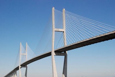
Sidney Lanier Bridge, Cable-stayed road bridge in Brunswick, United States

The Sidney Lanier Bridge extends 2,371 meters (7,779 feet) across the Brunswick River, carrying four lanes of U.S. Route 17 at a height of 150 meters (492 feet) above the water. The cable-stayed design links both riverbanks through a symmetrical pattern of steel cables that fan out from tall pylons and support the roadway.

After ship collisions with the original lift bridge in 1972 and 1987, the region decided to build this new structure. The construction opened in 2003, allowing larger cargo ships to pass safely beneath the elevated roadway.

The name honors Sidney Lanier, a Georgia poet who lived in the 19th century. Local residents use the crossing as their everyday route to work, while walkers on the footpath enjoy the wide view over the river mouth.

Drivers use the crossing as part of U.S. Route 17 along the Atlantic coast, while pedestrians walk best early in the morning or late in the evening when traffic thins. The climb to the center of the span is gradual, but the exposed location means wind can be noticeable.

An amateur radio repeater with the call sign WX4BWK is installed on one of the pylons, allowing radio enthusiasts to communicate over long distances along the coast. The equipment broadcasts from this exposed height and reaches an area stretching far inland and across the open water.

Location: Brunswick

Inception: 2003

Official opening: 2003

Length: 2,371 m

GPS coordinates: 31.11639,-81.48472

Latest update: December 5, 2025 22:28

Photos
Around this place
Igbo Landing Historic Site
United States of America

Igbo Landing Historic Site

12.2 km
Jekyll Island Club
United States of America

Jekyll Island Club

8.6 km
Fort Frederica National Monument
United States of America

Fort Frederica National Monument

14.9 km
St. Simons Island Light
United States of America

St. Simons Island Light

9.1 km
Horton House Historic Site
United States of America

Horton House Historic Site

6.9 km
Rockefeller Cottage
United States of America

Rockefeller Cottage

8.9 km
Brunswick Old Town Historic District
United States of America

Brunswick Old Town Historic District

3.3 km
Summer Waves Waterpark
United States of America

Summer Waves Waterpark

10.7 km
Christ Church
United States of America

Christ Church

14.8 km
Jekyll Island Museum
United States of America

Jekyll Island Museum

9.1 km
Massengale Beach
United States of America

Massengale Beach

10.6 km
Faith Chapel
United States of America

Faith Chapel

8.6 km
Walter Rogers Furness Cottage
United States of America

Walter Rogers Furness Cottage

9.1 km
The King and Prince Beach & Golf Resort
United States of America

The King and Prince Beach & Golf Resort

10.4 km
Ballard School
United States of America

Ballard School

10 km
Old Glynn County Courthouse
United States of America

Old Glynn County Courthouse

4.2 km
Frank M. Scarlett Federal Building
United States of America

Frank M. Scarlett Federal Building

3.8 km
Colored Memorial School and Risley High School
United States of America

Colored Memorial School and Risley High School

4.4 km
Windsor Park Historic District
United States of America

Windsor Park Historic District

3.7 km
Strachan House Garage
United States of America

Strachan House Garage

8.5 km
5th Street Public Beach Access
United States of America

5th Street Public Beach Access

9.7 km
Old Glynn Academy Building
United States of America

Old Glynn Academy Building

3.6 km
Saint Andrew Beach
United States of America

Saint Andrew Beach

12.5 km
Hamilton Plantation Slave Cabins
United States of America

Hamilton Plantation Slave Cabins

9.5 km
7th Street Public Beach Access
United States of America

7th Street Public Beach Access

9.5 km
Myrtle Street Public Beach Access
United States of America

Myrtle Street Public Beach Access

10.1 km
Jekyll Point
United States of America

Jekyll Point

12.2 km
Neptune Road Public Beach Access
United States of America

Neptune Road Public Beach Access

10.3 km
Show the full map
Reviews

Visited this place? Tap the stars to rate it and share your experience / photos with the community! Try now! You can cancel it anytime.

« Sidney Lanier Bridge - Cable-stayed road bridge in Brunswick, United States » is provided by Around Us (aroundus.com). Images and texts are derived from Wikimedia project under a Creative Commons license. You are allowed to copy, distribute, and modify copies of this page, under the conditions set by the license, as long as this note is clearly visible.

Discover hidden gems everywhere you go!

From secret cafés to breathtaking viewpoints, skip the crowded tourist spots and find places that match your style. Our app makes it easy with voice search, smart filtering, route optimization, and insider tips from travelers worldwide. Download now for the complete mobile experience.

Around Us App Screenshot

A unique approach to discovering new places

Le Figaro

All the places worth exploring

France Info

A tailor-made excursion in just a few clicks

20 Minutes