Enable Location

We need your location to show you interesting places around you

Discover nearby places

Find interesting locations and hidden gems around you

Precise directions

Get accurate directions and distances to places

Your location is never shared with other users. It's only used when you tap the location button.

Santa Margarita Lake

Log in to your account

Start exploring — it's free

Trusted by 62,140 travelers worldwide

Continue with Google
Continue with Apple
or

We will send you a code to connect

By continuing, you accept our Terms and Conditions and our Privacy Policy

Check your inbox

We've sent a pincode in your inbox. Please enter the code below.

Santa Margarita Lake

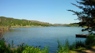
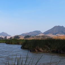
Santa Margarita Lake, lake in California, USA

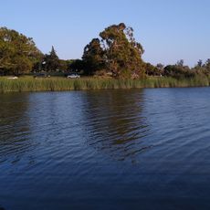
Santa Margarita Lake is a reservoir in California that spans over a thousand acres and is surrounded by wooded mountains. The water is held back by a dam built in 1941 and serves as a drinking water source for the city of San Luis Obispo.

The lake was created in 1941 with the construction of the Salinas Dam to store water for a nearby military camp. Since then, it has developed into a major water supply facility for the region.

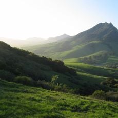
The lake takes its name from the nearby town of Santa Margarita and has long served as a gathering place for recreation and relaxation. Visitors use it for fishing, boating, and picnicking, creating a friendly community presence around the water.

The lake is easily reached from the town of Santa Margarita on Route 58, about 7 miles from the main highway. A recreation area with primitive campsites, picnic spots, and a network of trails allows various activities, though swimming in the lake itself is not permitted but a small pool is available on-site.

The shoreline of the lake has an unusual shape often compared to a dragon, with many twisted inlets and small islands. This complex structure creates hidden coves and changing views that make exploring by water particularly interesting.

The community of curious travelers

AroundUs brings together thousands of curated places, local tips, and hidden gems, enriched daily by 60,000 contributors worldwide.

Start exploring
Location
GPS coordinates
35.32787,-120.47092
Latest update
February 7, 2026 11:00
Around this place
Bishop Peak
United States of America

Bishop Peak

20.8 km
Pismo State Beach
United States of America

Pismo State Beach

28.3 km
Charles Paddock Zoo
United States of America

Charles Paddock Zoo

23.8 km
Cerro San Luis Obispo
United States of America

Cerro San Luis Obispo

19.7 km
Los Osos Oaks State Natural Reserve
United States of America

Los Osos Oaks State Natural Reserve

31.3 km
The "P"
United States of America

The "P"

16.7 km
Hollister Peak
United States of America

Hollister Peak

28.8 km
Islay Hill
United States of America

Islay Hill

16.6 km
Santa Margarita de Cortona Asistencia
United States of America

Santa Margarita de Cortona Asistencia

15.2 km
Pismo Beach
United States of America

Pismo Beach

27.7 km
Carlton Hotel
United States of America

Carlton Hotel

25.5 km
Chumash Peak
United States of America

Chumash Peak

21.6 km
San Luis Obispo Octagon Barn
United States of America

San Luis Obispo Octagon Barn

21.5 km
Robert Jack House
United States of America

Robert Jack House

18.5 km
San Luis Obispo Railroad Museum
United States of America

San Luis Obispo Railroad Museum

17.9 km
San Luis Obispo Botanical Garden
United States of America

San Luis Obispo Botanical Garden

22.8 km
Leaning Pine Arboretum
United States of America

Leaning Pine Arboretum

17.6 km
Dallidet Adobe
United States of America

Dallidet Adobe

17.6 km
Laguna Lake
United States of America

Laguna Lake

21.2 km
San Luis Obispo Carnegie Library
United States of America

San Luis Obispo Carnegie Library

18.3 km
The Powerhouse
United States of America

The Powerhouse

17.6 km
Myron Angel House
United States of America

Myron Angel House

18.2 km
Arroyo Grande IOOF Hall
United States of America

Arroyo Grande IOOF Hall

24.9 km
Atascadero Administration Building
United States of America

Atascadero Administration Building

25.3 km
John Price House
United States of America

John Price House

25.2 km
William Shipsey House
United States of America

William Shipsey House

16.8 km
Cerro Romauldo
United States of America

Cerro Romauldo

23.3 km
Avila Beach Resort Golf Course
United States of America

Avila Beach Resort Golf Course

29.1 km
Show the full map
« Santa Margarita Lake - lake in California, USA » is provided by Around Us (aroundus.com). Images and texts are derived from Wikimedia project under a Creative Commons license. You are allowed to copy, distribute, and modify copies of this page, under the conditions set by the license, as long as this note is clearly visible.

Discover hidden gems everywhere you go!

From secret cafés to breathtaking viewpoints, skip the crowded tourist spots and find places that match your style. Our app makes it easy with voice search, smart filtering, route optimization, and insider tips from travelers worldwide. Download now for the complete mobile experience.

Around Us App Screenshot

A unique approach to discovering new places

Le Figaro

All the places worth exploring

France Info

A tailor-made excursion in just a few clicks

20 Minutes

Around Us
Travel Guide & Maps
Download

Send to your phone

QR Code
1

Open the camera app on your mobile.

2

Point at the QR code with your camera. A notification will appear.

3

Tap the notification to open the link.