Enable Location

We need your location to show you interesting places around you

Discover nearby places

Find interesting locations and hidden gems around you

Precise directions

Get accurate directions and distances to places

Your location is never shared with other users. It's only used when you tap the location button.

Fremont Peak State Park

Log in to your account

Start exploring — it's free

Trusted by 65,790 travelers worldwide

Continue with Google
Continue with Apple
or

We will send you a code to connect

By continuing, you accept our Terms and Conditions and our Privacy Policy

Check your inbox

We've sent a pincode in your inbox. Please enter the code below.

Fremont Peak State Park
Discussion Reviews 1 Photos
5.9k Popularity

Fremont Peak State Park, State park in Gabilan Mountains, California, USA.

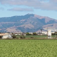
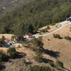
Fremont Peak State Park is a natural area in the Gabilan Mountains of San Benito County, with a summit reaching about 966 meters (3,169 feet). The terrain shifts between oak woodland, scrubland, and native grassland, all connected by a network of marked trails.

The peak takes its name from explorer John C. Frémont, who in 1846 raised an American flag on this hill during a mapping expedition through western territories. The act created a short standoff with Mexican authorities, who still controlled the region at the time.

The observatory at the summit runs regular stargazing nights where visitors can look through professional-grade telescopes. These evenings draw people from across the region who gather around a shared interest in the night sky.

The campground and picnic areas fill up quickly on weekends, so arriving early in the day makes things easier, especially in summer. Stargazing program spots tend to go fast, so checking availability ahead of time is a good idea.

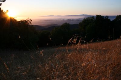
On a clear day, the summit offers a view of Monterey Bay, Santa Clara Valley, and San Benito Valley all at once, which is rare from a single inland vantage point. This position between three geographic regions makes the top feel like a natural crossroads of central California.

The community of curious travelers

AroundUs brings together thousands of curated places, local tips, and hidden gems, enriched daily by 60,000 contributors worldwide.

Start exploring
Location
Inception
1934
GPS coordinates
36.76000,-121.50200
Latest update
March 3, 2026 10:09
Around this place
Fremont Peak
United States of America

Fremont Peak

363 m
National Steinbeck Center
United States of America

National Steinbeck Center

16.5 km
Casa de Fruta
United States of America

Casa de Fruta

27.7 km
San Juan Bautista State Historic Park
United States of America

San Juan Bautista State Historic Park

10 km
Moss Landing State Beach
United States of America

Moss Landing State Beach

26.4 km
Salinas River State Beach
United States of America

Salinas River State Beach

26.3 km
Salinas River National Wildlife Refuge
United States of America

Salinas River National Wildlife Refuge

27 km
Fremont Peak Observatory
United States of America

Fremont Peak Observatory

268 m
Jose Castro House
United States of America

Jose Castro House

9.9 km
Rancho Las Palmas
United States of America

Rancho Las Palmas

21.6 km
Old City Hall
United States of America

Old City Hall

28.2 km
Juan de Anza House
United States of America

Juan de Anza House

9.8 km
Jose Eusebio Boronda Adobe
United States of America

Jose Eusebio Boronda Adobe

17 km
Monterey County Court House
United States of America

Monterey County Court House

17 km
Krough House
United States of America

Krough House

16.9 km
Hollister Carnegie Library
United States of America

Hollister Carnegie Library

13.5 km
Godfrey M. Bockius House
United States of America

Godfrey M. Bockius House

27.9 km
Sheriff William Joseph Nesbitt House
United States of America

Sheriff William Joseph Nesbitt House

16.9 km
Rozas House
United States of America

Rozas House

10 km
Castroville Japanese Language School
United States of America

Castroville Japanese Language School

22.1 km
Giant artichoke
United States of America

Giant artichoke

22.4 km
Samuel M. Black House
United States of America

Samuel M. Black House

16.5 km
Peter J. Bontadelli House
United States of America

Peter J. Bontadelli House

25.6 km
Porter-Vallejo Mansion
United States of America

Porter-Vallejo Mansion

27.1 km
B. V. Sargent House
United States of America

B. V. Sargent House

16.9 km
Benjamin Wilcox House
United States of America

Benjamin Wilcox House

9.4 km
Judge Lee House
United States of America

Judge Lee House

28.1 km
Marentis House
United States of America

Marentis House

10.2 km
Show the full map
Reviews
Share your experience

No review yet

Discussions
Start a discussion...

No discussion yet

« Fremont Peak State Park - State park in Gabilan Mountains, California, USA » is provided by Around Us (aroundus.com). Images and texts are derived from Wikimedia project under a Creative Commons license. You are allowed to copy, distribute, and modify copies of this page, under the conditions set by the license, as long as this note is clearly visible.

Discover hidden gems everywhere you go!

From secret cafés to breathtaking viewpoints, skip the crowded tourist spots and find places that match your style. Our app makes it easy with voice search, smart filtering, route optimization, and insider tips from travelers worldwide. Download now for the complete mobile experience.

Around Us App Screenshot

A unique approach to discovering new places

Le Figaro

All the places worth exploring

France Info

A tailor-made excursion in just a few clicks

20 Minutes

Around Us
Travel Guide & Maps
Download

Send to your phone

QR Code
1

Open the camera app on your mobile.

2

Point at the QR code with your camera. A notification will appear.

3

Tap the notification to open the link.