Enable Location

We need your location to show you interesting places around you

Discover nearby places

Find interesting locations and hidden gems around you

Precise directions

Get accurate directions and distances to places

Your location is never shared with other users. It's only used when you tap the location button.

Radio Beach

Log in to your account

Start exploring — it's free

Trusted by 62,562 travelers worldwide

Continue with Google
Continue with Apple
or

We will send you a code to connect

By continuing, you accept our Terms and Conditions and our Privacy Policy

Check your inbox

We've sent a pincode in your inbox. Please enter the code below.

Radio Beach

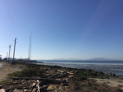
Radio Beach, Public beach near Oakland Bay Bridge, California.

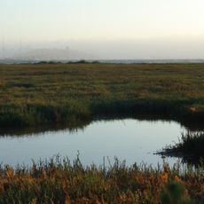
Radio Beach is a public beach along the San Francisco Bay shoreline east of the Bay Bridge, offering direct views of Mount Tamalpais and Angel Island. The shoreline extends roughly 400 feet and sits adjacent to radio transmission towers that gave the location its name.

The beach took its name from the radio transmission towers that have marked the area for decades. It later became known as Toll Plaza Beach because of the nearby Bay Bridge toll collection points.

The beach area incorporates public art installations that reflect the local culture while serving as a meeting point for community gatherings and events.

Access the beach by taking the West Grand Avenue Maritime exit and following the frontage road toward the bay. The location is straightforward to reach, though arriving early helps secure parking near the water.

This is Oakland's only public water access point and attracts kitesurfers from March through June when wind conditions are ideal. The seasonal sport activity creates a gathering place for windsport enthusiasts in the area.

The community of curious travelers

AroundUs brings together thousands of curated places, local tips, and hidden gems, enriched daily by 60,000 contributors worldwide.

Start exploring
Location
Address
Radio Beach, Oakland, CA 94607, USA
GPS coordinates
37.82490,-122.31800
Latest update
December 13, 2025 11:47
Around this place
San Francisco–Oakland Bay Bridge
United States of America

San Francisco–Oakland Bay Bridge

2.6 km
Eastern span replacement of the San Francisco–Oakland Bay Bridge
United States of America

Eastern span replacement of the San Francisco–Oakland Bay Bridge

3.1 km
Naval Air Station Alameda
United States of America

Naval Air Station Alameda

4.3 km
Hughes Mining Barge
United States of America

Hughes Mining Barge

4.3 km
Fox Oakland Theatre
United States of America

Fox Oakland Theatre

4.7 km
Emeryville Shellmound
United States of America

Emeryville Shellmound

2.4 km
Oakland City Hall
United States of America

Oakland City Hall

4.6 km
Museum of Art and Digital Entertainment
United States of America

Museum of Art and Digital Entertainment

4.6 km
California Hotel
United States of America

California Hotel

3.5 km
China Clipper flight departure site
United States of America

China Clipper flight departure site

4.5 km
Adventure Playground
United States of America

Adventure Playground

4.3 km
Administration Building, Treasure Island
United States of America

Administration Building, Treasure Island

4.7 km
Emeryville Crescent State Marine Reserve
United States of America

Emeryville Crescent State Marine Reserve

1.3 km
Ronald V. Dellums Federal Building
United States of America

Ronald V. Dellums Federal Building

4.4 km
African American Museum and Library at Oakland
United States of America

African American Museum and Library at Oakland

4.2 km
Cathedral Building
United States of America

Cathedral Building

4.7 km
Pardee Home
United States of America

Pardee Home

4.2 km
Cathedral of Saint Francis de Sales
United States of America

Cathedral of Saint Francis de Sales

4.3 km
555 City Center
United States of America

555 City Center

4.4 km
United States lightship Relief
United States of America

United States lightship Relief

4.6 km
Berkeley I-80 bridge
United States of America

Berkeley I-80 bridge

4.6 km
Yerba Buena Light
United States of America

Yerba Buena Light

4.3 km
10th Street Market
United States of America

10th Street Market

4.6 km
Elihu M. Harris State Office Building
United States of America

Elihu M. Harris State Office Building

4.4 km
Hall of Transportation, Treasure Island
United States of America

Hall of Transportation, Treasure Island

4.4 km
Greek Orthodox Church of the Assumption
United States of America

Greek Orthodox Church of the Assumption

4.2 km
Palace of Fine and Decorative Arts, Treasure Island
United States of America

Palace of Fine and Decorative Arts, Treasure Island

4.2 km
African American Museum and Library at Oakland
United States of America

African American Museum and Library at Oakland

4.2 km
Show the full map
« Radio Beach - Public beach near Oakland Bay Bridge, California » is provided by Around Us (aroundus.com). Images and texts are derived from Wikimedia project under a Creative Commons license. You are allowed to copy, distribute, and modify copies of this page, under the conditions set by the license, as long as this note is clearly visible.

Discover hidden gems everywhere you go!

From secret cafés to breathtaking viewpoints, skip the crowded tourist spots and find places that match your style. Our app makes it easy with voice search, smart filtering, route optimization, and insider tips from travelers worldwide. Download now for the complete mobile experience.

Around Us App Screenshot

A unique approach to discovering new places

Le Figaro

All the places worth exploring

France Info

A tailor-made excursion in just a few clicks

20 Minutes

Around Us
Travel Guide & Maps
Download

Send to your phone

QR Code
1

Open the camera app on your mobile.

2

Point at the QR code with your camera. A notification will appear.

3

Tap the notification to open the link.