Chest opened
+${chestReward.xp} XP
Explorer
NOUVEAU ×${chestReward.collectible.quantity}
tapez pour fermer
Chest locked

Open chests in the app

Around Us is built for your phone — chests unlock when you walk, explore and capture nearby places.

Enable Location

We need your location to show you interesting places around you

Discover nearby places

Find interesting locations and hidden gems around you

Precise directions

Get accurate directions and distances to places

Your location is never shared with other users. It's only used when you tap the location button.

Log in to your account

Start exploring — it's free

Trusted by 73,010 travelers worldwide

Continue with Google
Continue with Apple
or

We will send you a code to connect

By continuing, you accept our Terms and Conditions and our Privacy Policy

Check your inbox

We've sent a pincode in your inbox. Please enter the code below.

Southeast Water Pollution Control Plant
Discussion Reviews Photo
1.2k Popularity

Southeast Water Pollution Control Plant, Water treatment facility in Bayview-Hunters Point, San Francisco, US

The Southeast Water Pollution Control Plant is a wastewater treatment facility in San Francisco that handles used water from the eastern part of the city. It operates multiple clarifying tanks and treatment systems designed to remove contaminants before the water is discharged into the bay.

The plant opened in 1952 to handle growing wastewater needs from the eastern neighborhoods of San Francisco. Over the decades, it has been expanded and upgraded with new technology to keep pace with the city's development.

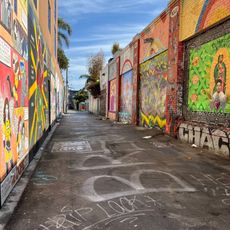
The plant displays murals created by local artists in its public-facing areas, adding color to the industrial landscape. These artworks celebrate the neighborhood's character and connect the facility to the community that surrounds it.

The facility is an active industrial site not typically open to the public for tours or casual visits. Those interested in learning about wastewater treatment should inquire about occasional educational programs or community events held there.

The plant processes sludge through anaerobic digestion to produce biogas that is converted into renewable natural gas. This recovered gas feeds directly into Pacific Gas and Electric's pipeline network, turning waste into usable energy.

The community of curious travelers

AroundUs brings together thousands of curated places, local tips, and hidden gems, enriched daily by 60,000 contributors worldwide.

Start exploring
GPS coordinates
37.74200,-122.39100
Latest update
December 14, 2025 18:20
Around this place
Candlestick Park
United States of America

Candlestick Park

3.2 km
Seals Stadium
United States of America

Seals Stadium

3.2 km
Clarion Alley
United States of America

Clarion Alley

3.5 km
Sam Jordan's Bar
United States of America

Sam Jordan's Bar

216 m
Bernal Heights Summit
United States of America

Bernal Heights Summit

2.2 km
Bottom of the Hill
United States of America

Bottom of the Hill

2.6 km
Potrero Point
United States of America

Potrero Point

1.8 km
Redstone Building
United States of America

Redstone Building

3.5 km
Alamo Drafthouse New Mission Cinema
United States of America

Alamo Drafthouse New Mission Cinema

2.9 km
Bayview Opera House
United States of America

Bayview Opera House

766 m
Baker and Hamilton Building
United States of America

Baker and Hamilton Building

3.4 km
Albion Brewery
United States of America

Albion Brewery

1.8 km
Jerry Garcia Amphitheatre
United States of America

Jerry Garcia Amphitheatre

3.3 km
Kadist Art Foundation
United States of America

Kadist Art Foundation

2.8 km
Institute of Contemporary Art San Francisco
United States of America

Institute of Contemporary Art San Francisco

2 km
Potrero Hill Neighborhood House
United States of America

Potrero Hill Neighborhood House

2 km
Minnesota Street Project
United States of America

Minnesota Street Project

1.4 km
Building 101
United States of America

Building 101

2.1 km
Girls Club
United States of America

Girls Club

3.1 km
Trinity Presbyterian Church
United States of America

Trinity Presbyterian Church

3.5 km
Quinn House, San Francisco
United States of America

Quinn House, San Francisco

709 m
Frank G. Edwards House
United States of America

Frank G. Edwards House

2.9 km
United States of America

Hunters View

1.1 km
Bernal Heights Branch Library
United States of America

Bernal Heights Branch Library

2.2 km
Portola Branch Library
United States of America

Portola Branch Library

2.2 km
Mission Branch Library
United States of America

Mission Branch Library

2.8 km
Sylvester House
United States of America

Sylvester House

1.2 km
Liberty Street Historic District
United States of America

Liberty Street Historic District

3.3 km
Show the full map
Reviews
Share your experience

No review yet

Discussions
Start a discussion...

No discussion yet

« Southeast Water Pollution Control Plant - Water treatment facility in Bayview-Hunters Point, San Francisco, US » is provided by Around Us (aroundus.com). Images and texts are derived from Wikimedia project under a Creative Commons license. You are allowed to copy, distribute, and modify copies of this page, under the conditions set by the license, as long as this note is clearly visible.

Discover hidden gems everywhere you go!

From secret cafés to breathtaking viewpoints, skip the crowded tourist spots and find places that match your style. Our app makes it easy with voice search, smart filtering, route optimization, and insider tips from travelers worldwide. Download now for the complete mobile experience.

Around Us App Screenshot

A unique approach to discovering new places

Le Figaro

All the places worth exploring

France Info

A tailor-made excursion in just a few clicks

20 Minutes

Around Us
Travel Guide & Maps
Download

Send to your phone

QR Code
1

Open the camera app on your mobile.

2

Point at the QR code with your camera. A notification will appear.

3

Tap the notification to open the link.