Enable Location

We need your location to show you interesting places around you

Discover nearby places

Find interesting locations and hidden gems around you

Precise directions

Get accurate directions and distances to places

Your location is never shared with other users. It's only used when you tap the location button.

Prairie Creek Fish Hatchery

Log in to your account

Start exploring — it's free

Trusted by 62,473 travelers worldwide

Continue with Google
Continue with Apple
or

We will send you a code to connect

By continuing, you accept our Terms and Conditions and our Privacy Policy

Check your inbox

We've sent a pincode in your inbox. Please enter the code below.

Prairie Creek Fish Hatchery, distrikt historik në Shtetet e Bashkuara

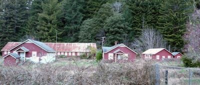
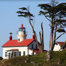
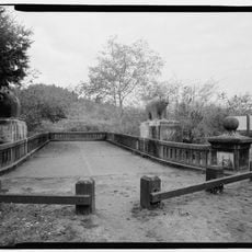
The Prairie Creek Fish Hatchery is a historic fish breeding facility in Humboldt County, about 6 miles north of Orick near Highway 101. The site contains original ponds, five water tanks, a pipeline system carrying water to fish rearing areas, and residential and work buildings constructed in the 1930s.

The facility was built in 1936 by the Works Progress Administration, an employment program during the Great Depression. It was part of a state effort to support salmon and trout populations in nearby rivers.

The name refers to Prairie Creek and the hatchery's role in supporting local fishing. The site embodies a time when government work brought families and workers to live together on a shared mission to restore fish populations.

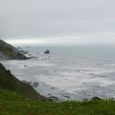
The site sits directly off Highway 101 and is easy to locate using milepost 124.83 north of Orick. Access to the grounds is straightforward, though visitors should exercise caution when exploring the historic structures.

Of over 150 fish hatcheries built in California between the late 1800s and 1900s, Prairie Creek is one of only three that has preserved most of its original structures and equipment. This makes it a rare example of early fish breeding technology and a valuable record of that era's work.

The community of curious travelers

AroundUs brings together thousands of curated places, local tips, and hidden gems, enriched daily by 60,000 contributors worldwide.

Start exploring
Location
GPS coordinates
41.33283,-124.03033
Latest update
February 9, 2026 07:46
Around this place
Hyperion
United States of America

Hyperion

14.3 km
Redwood National and State Parks
United States of America

Redwood National and State Parks

5.3 km
Trees of Mystery
United States of America

Trees of Mystery

28.4 km
Prairie Creek Redwoods State Park
United States of America

Prairie Creek Redwoods State Park

7.9 km
Del Norte Coast Redwoods State Park
United States of America

Del Norte Coast Redwoods State Park

38.4 km
Battery Point Light
United States of America

Battery Point Light

48 km
Trinidad State Beach
United States of America

Trinidad State Beach

31.3 km
Coast Guard Air Station Humboldt Bay
United States of America

Coast Guard Air Station Humboldt Bay

40.2 km
Siskiyou Wilderness
United States of America

Siskiyou Wilderness

45.7 km
Humboldt Lagoons State Park
United States of America

Humboldt Lagoons State Park

12.9 km
Azalea State Natural Reserve
United States of America

Azalea State Natural Reserve

46.3 km
Little River State Beach
United States of America

Little River State Beach

35.9 km
Trinidad Head Light
United States of America

Trinidad Head Light

32.9 km
Redwood Experimental Forest
United States of America

Redwood Experimental Forest

28.2 km
Klamath River Bridge
United States of America

Klamath River Bridge

20.5 km
Moonstone Beach
United States of America

Moonstone Beach

34.4 km
Trinidad State Beach
United States of America

Trinidad State Beach

31.4 km
Brotherhood Tree
United States of America

Brotherhood Tree

28.5 km
Crescent Beach
United States of America

Crescent Beach

45.2 km
Redwood Creek Beach
United States of America

Redwood Creek Beach

7.4 km
Wilson Creek Beach
United States of America

Wilson Creek Beach

30.5 km
Douglas Memorial Bridge
United States of America

Douglas Memorial Bridge

21.3 km
Crescent Beach
United States of America

Crescent Beach

45.5 km
United States of America

Wilson Creek Beach

30.5 km
Hidden Beach
United States of America

Hidden Beach

27.8 km
Clam Beach
United States of America

Clam Beach

38.2 km
Elk Prairie
United States of America

Elk Prairie

2.8 km
Cannonball Beach
United States of America

Cannonball Beach

25 km
Show the full map
« Prairie Creek Fish Hatchery - distrikt historik në Shtetet e Bashkuara » is provided by Around Us (aroundus.com). Images and texts are derived from Wikimedia project under a Creative Commons license. You are allowed to copy, distribute, and modify copies of this page, under the conditions set by the license, as long as this note is clearly visible.

Discover hidden gems everywhere you go!

From secret cafés to breathtaking viewpoints, skip the crowded tourist spots and find places that match your style. Our app makes it easy with voice search, smart filtering, route optimization, and insider tips from travelers worldwide. Download now for the complete mobile experience.

Around Us App Screenshot

A unique approach to discovering new places

Le Figaro

All the places worth exploring

France Info

A tailor-made excursion in just a few clicks

20 Minutes

Around Us
Travel Guide & Maps
Download

Send to your phone

QR Code
1

Open the camera app on your mobile.

2

Point at the QR code with your camera. A notification will appear.

3

Tap the notification to open the link.