Enable Location

We need your location to show you interesting places around you

Discover nearby places

Find interesting locations and hidden gems around you

Precise directions

Get accurate directions and distances to places

Your location is never shared with other users. It's only used when you tap the location button.

Redwood National and State Parks

Log in to your account

Start exploring — it's free

Trusted by 63,017 travelers worldwide

Continue with Google
Continue with Apple
or

We will send you a code to connect

By continuing, you accept our Terms and Conditions and our Privacy Policy

Check your inbox

We've sent a pincode in your inbox. Please enter the code below.

Discussion Reviews 2 Photos
225k Popularity

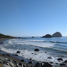
Redwood National and State Parks, National park group in northern California, United States.

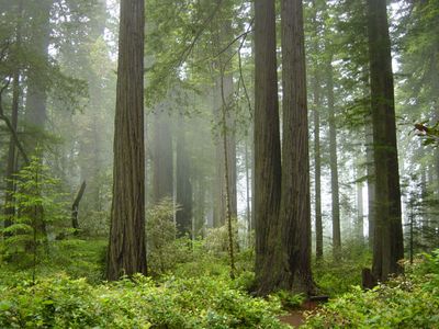
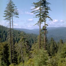
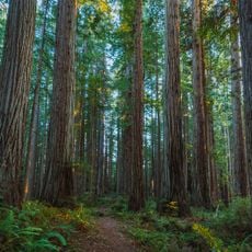
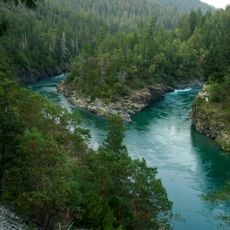
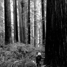
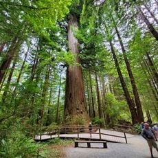
Redwood National and State Parks is a network of protected reserves along the northern California coast, combining federal and state lands into a single managed area. Towering groves rise from valleys carved by seasonal streams, their canopies filtering light into green-tinted shadows that stretch across fern-covered forest floors.

Congress authorized the national park in 1968 after conservationists campaigned to protect remaining old-growth stands from industrial logging. Three existing California state parks later merged into the federal system to create a unified management zone.

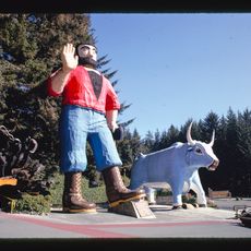
Early inhabitants wove bark into clothing and shelters before European contact changed forest use patterns forever. Today visitors walk quietly among the groves, aware they are crossing territory once shaped by seasonal harvests and controlled burns.

Roads through the reserves wind between the groves and may be narrow in places, so drivers should watch for wildlife crossing and proceed slowly. Trails range from short loops near parking areas to longer routes into backcountry zones, and sturdy footwear helps on uneven ground.

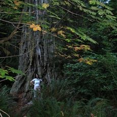
Park officials keep the locations of the tallest specimens secret to prevent visitor damage to their root systems and surrounding soil. Only a handful of researchers know where to find them, and trails do not lead directly to these record holders.

The community of curious travelers

AroundUs brings together thousands of curated places, local tips, and hidden gems, enriched daily by 60,000 contributors worldwide.

Start exploring
Location
Location
Inception
October 2, 1968
Operator
National Park Service;California Department of Parks and Recreation
Phone
GPS coordinates
41.37389,-123.99806
Latest update
December 15, 2025 02:08
Around this place
Hyperion
United States of America

Hyperion

18.9 km
Redwood National and State Parks
United States of America

Redwood National and State Parks

18 km
Jedediah Smith Redwoods State Park
United States of America

Jedediah Smith Redwoods State Park

46.2 km
Trees of Mystery
United States of America

Trees of Mystery

24.6 km
Prairie Creek Redwoods State Park
United States of America

Prairie Creek Redwoods State Park

4.7 km
United States of America

Grove of Titans

45.8 km
Del Norte Coast Redwoods State Park
United States of America

Del Norte Coast Redwoods State Park

34.1 km
Lost Monarch
United States of America

Lost Monarch

46.8 km
Smith River National Recreation Area
United States of America

Smith River National Recreation Area

43.9 km
Humboldt Lagoons State Park
United States of America

Humboldt Lagoons State Park

18.2 km
Camp Lincoln
United States of America

Camp Lincoln

50.9 km
Prairie Creek Fish Hatchery
United States of America

Prairie Creek Fish Hatchery

5.3 km
Redwood Experimental Forest
United States of America

Redwood Experimental Forest

24.4 km
United States of America

Orick Peanut

11.8 km
Klamath River Bridge
United States of America

Klamath River Bridge

16.2 km
United States of America

Old Redwood Highway

27.8 km
United States of America

Lyons Ranches Historic District

27.4 km
United States of America

Myrtle Creek Bridge

47.8 km
Brotherhood Tree
United States of America

Brotherhood Tree

24.6 km
United States of America

Stone Lagoon Visitor Center

17.3 km
Redwood Creek Beach
United States of America

Redwood Creek Beach

12.6 km
Wilson Creek Beach
United States of America

Wilson Creek Beach

26.8 km
United States of America

Hiouchi Information Center

47.8 km
United States of America

Prairie Creek Visitor Center

2.4 km
United States of America

Freshwater Rocks

14.7 km
United States of America

High Bluff Beach

19.1 km
Douglas Memorial Bridge
United States of America

Douglas Memorial Bridge

17.2 km
United States of America

High Bluff

16.8 km
Show the full map
Reviews
Share your experience

No review yet

Discussions
Start a discussion...

No discussion yet

« Redwood National and State Parks - National park group in northern California, United States » is provided by Around Us (aroundus.com). Images and texts are derived from Wikimedia project under a Creative Commons license. You are allowed to copy, distribute, and modify copies of this page, under the conditions set by the license, as long as this note is clearly visible.

Discover hidden gems everywhere you go!

From secret cafés to breathtaking viewpoints, skip the crowded tourist spots and find places that match your style. Our app makes it easy with voice search, smart filtering, route optimization, and insider tips from travelers worldwide. Download now for the complete mobile experience.

Around Us App Screenshot

A unique approach to discovering new places

Le Figaro

All the places worth exploring

France Info

A tailor-made excursion in just a few clicks

20 Minutes

Around Us
Travel Guide & Maps
Download

Send to your phone

QR Code
1

Open the camera app on your mobile.

2

Point at the QR code with your camera. A notification will appear.

3

Tap the notification to open the link.