Enable Location

We need your location to show you interesting places around you

Discover nearby places

Find interesting locations and hidden gems around you

Precise directions

Get accurate directions and distances to places

Your location is never shared with other users. It's only used when you tap the location button.

Arcata Community Forest

Log in to your account

Start exploring — it's free

Trusted by 65,036 travelers worldwide

Continue with Google
Continue with Apple
or

We will send you a code to connect

By continuing, you accept our Terms and Conditions and our Privacy Policy

Check your inbox

We've sent a pincode in your inbox. Please enter the code below.

Arcata Community Forest
Discussion Reviews 1 Photos
3k Popularity

Arcata Community Forest, Protected redwood forest in Arcata, California.

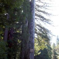
Arcata Community Forest is a city-owned forest on the edge of Arcata in northern California, covered almost entirely in coast redwood trees. Trails wind through steep ravines, past creek beds, and across rolling terrain shaded by tall canopies.

The land was home to the Wiyot people before logging companies cleared much of the redwood forest in the late 1800s. The city purchased the land in 1955 and began managing it as a public forest, allowing the trees to grow back over the following decades.

Locals from Arcata walk, run, and ride through the forest on a daily basis, treating it as an extension of the neighborhood rather than a destination. Dogs are a common sight on the trails, and the forest feels more like a shared backyard than a managed reserve.

The forest has several entry points, including Redwood Park, Fickle Hill Road, and California Street, each with nearby parking. Trails range from flat creek-side paths to steep climbs, so it helps to check a trail map before heading in.

Part of the forest was added through a private agreement with a local family who allowed their land to become part of the public trail system. The loop trail that crosses this section is one of the most used routes in the forest and follows a creek for much of its length.

The community of curious travelers

AroundUs brings together thousands of curated places, local tips, and hidden gems, enriched daily by 60,000 contributors worldwide.

Start exploring
Location
GPS coordinates
40.87393,-124.05839
Latest update
March 3, 2026 13:52
Around this place
Carson Mansion
United States of America

Carson Mansion

11.3 km
Old Town Eureka
United States of America

Old Town Eureka

12 km
Arcata Wastewater Treatment Plant and Wildlife Sanctuary
United States of America

Arcata Wastewater Treatment Plant and Wildlife Sanctuary

3.3 km
Minor Theatre
United States of America

Minor Theatre

2.4 km
Coast Guard Air Station Humboldt Bay
United States of America

Coast Guard Air Station Humboldt Bay

12.3 km
Azalea State Natural Reserve
United States of America

Azalea State Natural Reserve

5.3 km
Samoa Cookhouse
United States of America

Samoa Cookhouse

12 km
Pythian Castle
United States of America

Pythian Castle

2.3 km
William McKinley statue
United States of America

William McKinley statue

2.5 km
Clarke Historical Museum
United States of America

Clarke Historical Museum

12 km
Hotel Arcata
United States of America

Hotel Arcata

2.4 km
Humboldt Bay Maritime Museum
United States of America

Humboldt Bay Maritime Museum

11.2 km
United States Post Office and Courthouse
United States of America

United States Post Office and Courthouse

11.9 km
Carnegie Free Library
United States of America

Carnegie Free Library

12.1 km
Eureka Theater
United States of America

Eureka Theater

12.1 km
HSU First Street Gallery
United States of America

HSU First Street Gallery

11.9 km
E. Janssen Building
United States of America

E. Janssen Building

11.9 km
Humboldt County Superior Court
United States of America

Humboldt County Superior Court

11.8 km
Eureka Municipal Auditorium
United States of America

Eureka Municipal Auditorium

12.4 km
Humboldt State University Natural History Museum
United States of America

Humboldt State University Natural History Museum

2.2 km
Morris Graves Museum of Art
United States of America

Morris Graves Museum of Art

12.1 km
The Old Arrow Tree, California
United States of America

The Old Arrow Tree, California

9.2 km
Old Jacoby Creek School
United States of America

Old Jacoby Creek School

3.5 km
Odd Fellows Hall
United States of America

Odd Fellows Hall

11.8 km
Thomas F. Ricks House
United States of America

Thomas F. Ricks House

12 km
George McFarlan House
United States of America

George McFarlan House

11.1 km
Morris Graves Museum of Art
United States of America

Morris Graves Museum of Art

12.2 km
Arkley Center for the Performing Arts
United States of America

Arkley Center for the Performing Arts

12 km
Show the full map
Reviews
Share your experience

No review yet

Discussions
Start a discussion...

No discussion yet

« Arcata Community Forest - Protected redwood forest in Arcata, California » is provided by Around Us (aroundus.com). Images and texts are derived from Wikimedia project under a Creative Commons license. You are allowed to copy, distribute, and modify copies of this page, under the conditions set by the license, as long as this note is clearly visible.

Discover hidden gems everywhere you go!

From secret cafés to breathtaking viewpoints, skip the crowded tourist spots and find places that match your style. Our app makes it easy with voice search, smart filtering, route optimization, and insider tips from travelers worldwide. Download now for the complete mobile experience.

Around Us App Screenshot

A unique approach to discovering new places

Le Figaro

All the places worth exploring

France Info

A tailor-made excursion in just a few clicks

20 Minutes

Around Us
Travel Guide & Maps
Download

Send to your phone

QR Code
1

Open the camera app on your mobile.

2

Point at the QR code with your camera. A notification will appear.

3

Tap the notification to open the link.