Enable Location

We need your location to show you interesting places around you

Discover nearby places

Find interesting locations and hidden gems around you

Precise directions

Get accurate directions and distances to places

Your location is never shared with other users. It's only used when you tap the location button.

Willapa National Wildlife Refuge

Log in to your account

Start exploring — it's free

Trusted by 66,033 travelers worldwide

Continue with Google
Continue with Apple
or

We will send you a code to connect

By continuing, you accept our Terms and Conditions and our Privacy Policy

Check your inbox

We've sent a pincode in your inbox. Please enter the code below.

Willapa National Wildlife Refuge
Discussion Reviews 1 Photos
3.7k Popularity

Willapa National Wildlife Refuge, National wildlife refuge in Pacific County, United States.

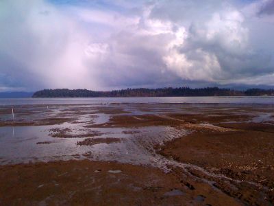
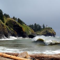
Willapa National Wildlife Refuge is a protected area on the coast of Washington State, made up of several separate sections around Willapa Bay and the Long Beach Peninsula. These sections cover tidelands, ocean beaches, streams, and patches of old-growth coastal forest.

The refuge was established in 1937 to protect habitat for migratory birds at a time when many coastal wetlands along the Pacific were being lost. Over the following decades, it grew to include more forest and shoreline sections.

The refuge sits along the Pacific Flyway, one of the main bird migration routes on the continent, so the wildlife you see changes completely depending on the season. Many visitors return several times a year to follow this rhythm.

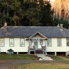
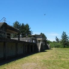
The refuge is split into several separate sections that are not connected to each other, so you need to drive between them if you want to visit more than one. A visitor contact station near Willapa Bay is a good starting point for orientation.

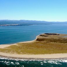
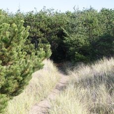
Ledbetter Point, one of the refuge sections, has a small stand of shore pine growing on a sand spit, which is a very rare type of coastal habitat on the Pacific coast of the United States. This spot is also one of the few places on the coast where you can walk from tideflats to ocean beach in just a short distance.

The community of curious travelers

AroundUs brings together thousands of curated places, local tips, and hidden gems, enriched daily by 60,000 contributors worldwide.

Start exploring
Location
Inception
1937
Shares border with
Teal Slough Natural Resources Conservation Area
GPS coordinates
46.44170,-123.96700
Latest update
March 3, 2026 14:02
Around this place
Astoria–Megler Bridge
United States of America

Astoria–Megler Bridge

26.2 km
Fort Stevens
United States of America

Fort Stevens

26.7 km
Cape Disappointment State Park
United States of America

Cape Disappointment State Park

18.6 km
Captain George Flavel House Museum
United States of America

Captain George Flavel House Museum

30 km
Oregon Film Museum
United States of America

Oregon Film Museum

29.9 km
Cape Disappointment Light
United States of America

Cape Disappointment Light

19.6 km
Fort Columbia State Park
United States of America

Fort Columbia State Park

20.6 km
North Head Light
United States of America

North Head Light

18 km
Leadbetter Point State Park
United States of America

Leadbetter Point State Park

20.6 km
Pacific Pines State Park
United States of America

Pacific Pines State Park

10.1 km
Columbia River Quarantine Station
United States of America

Columbia River Quarantine Station

21.8 km
Desdemona Sands Light
United States of America

Desdemona Sands Light

24.1 km
Samuel Elmore Cannery
United States of America

Samuel Elmore Cannery

29.4 km
Astoria Victory Monument
United States of America

Astoria Victory Monument

29.5 km
The Wreckage
United States of America

The Wreckage

8.2 km
Deep River Pioneer Lutheran Church
United States of America

Deep River Pioneer Lutheran Church

23.7 km
Clatsop County Courthouse
United States of America

Clatsop County Courthouse

29.9 km
Fort Stevens State Park
United States of America

Fort Stevens State Park

28.7 km
John Hobson House
United States of America

John Hobson House

29.8 km
Colbert House
United States of America

Colbert House

15.7 km
Astoria Wharf and Warehouse Company
United States of America

Astoria Wharf and Warehouse Company

29.5 km
Battery Russell
United States of America

Battery Russell

27.6 km
World Kite Museum
United States of America

World Kite Museum

12.8 km
Columbia Pacific Heritage Museum
United States of America

Columbia Pacific Heritage Museum

16 km
Old Clatsop County Jail
United States of America

Old Clatsop County Jail

29.9 km
Pier 12
United States of America

Pier 12

29.9 km
Pacific County Courthouse
United States of America

Pacific County Courthouse

27.4 km
Astoria Public Library
United States of America

Astoria Public Library

30 km
Show the full map
Reviews
Share your experience

No review yet

Discussions
Start a discussion...

No discussion yet

« Willapa National Wildlife Refuge - National wildlife refuge in Pacific County, United States » is provided by Around Us (aroundus.com). Images and texts are derived from Wikimedia project under a Creative Commons license. You are allowed to copy, distribute, and modify copies of this page, under the conditions set by the license, as long as this note is clearly visible.

Discover hidden gems everywhere you go!

From secret cafés to breathtaking viewpoints, skip the crowded tourist spots and find places that match your style. Our app makes it easy with voice search, smart filtering, route optimization, and insider tips from travelers worldwide. Download now for the complete mobile experience.

Around Us App Screenshot

A unique approach to discovering new places

Le Figaro

All the places worth exploring

France Info

A tailor-made excursion in just a few clicks

20 Minutes

Around Us
Travel Guide & Maps
Download

Send to your phone

QR Code
1

Open the camera app on your mobile.

2

Point at the QR code with your camera. A notification will appear.

3

Tap the notification to open the link.