Enable Location

We need your location to show you interesting places around you

Discover nearby places

Find interesting locations and hidden gems around you

Precise directions

Get accurate directions and distances to places

Your location is never shared with other users. It's only used when you tap the location button.

Desdemona Sands Light

Log in to your account

Start exploring — it's free

Trusted by 62,387 travelers worldwide

Continue with Google
Continue with Apple
or

We will send you a code to connect

By continuing, you accept our Terms and Conditions and our Privacy Policy

Check your inbox

We've sent a pincode in your inbox. Please enter the code below.

Desdemona Sands Light

Desdemona Sands Light, Historic lighthouse at Columbia River mouth, Oregon, United States.

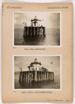
Desdemona Sands Light is an octagonal wooden lighthouse that stood at the mouth of the Columbia River in Oregon, built on a pile foundation. The structure was equipped with a fourth-order Fresnel lens to guide ships through this crucial waterway.

The lighthouse was built in 1901 to replace the earlier Point Adams Light at this challenging river entrance. It remained active until its deactivation in 1965 when newer navigation aids made this location less essential for maritime safety.

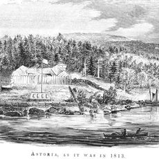
The lighthouse takes its name from the bark Desdemona, which ran aground on the shoals in 1857 and gave the area its name. Visitors can still trace this maritime incident through the place name that survives today.

The lighthouse was accessible only by water and had no residential facilities for staff and their families. Visitors planning to reach this location should know that water access is essential and conditions depend on river and tide circumstances.

The structure had a cistern system for collecting fresh water, which highlighted its isolation from the mainland. In 1933 it also received electrical power through a submarine cable, a remarkable technical achievement for that time.

The community of curious travelers

AroundUs brings together thousands of curated places, local tips, and hidden gems, enriched daily by 60,000 contributors worldwide.

Start exploring
Location
Inception
1901
GPS coordinates
46.22528,-123.95361
Latest update
December 14, 2025 09:41
Around this place
Astoria–Megler Bridge
United States of America

Astoria–Megler Bridge

7 km
Fort Stevens
United States of America

Fort Stevens

2.7 km
Fort Astoria
United States of America

Fort Astoria

10.6 km
Captain George Flavel House Museum
United States of America

Captain George Flavel House Museum

10 km
Oregon Film Museum
United States of America

Oregon Film Museum

10 km
John Jacob Astor Hotel
United States of America

John Jacob Astor Hotel

10.5 km
Cape Disappointment Light
United States of America

Cape Disappointment Light

9.4 km
Fort Columbia State Park
United States of America

Fort Columbia State Park

4.7 km
United States lightship Columbia
United States of America

United States lightship Columbia

10.7 km
Captain George Conrad Flavel House
United States of America

Captain George Conrad Flavel House

10.7 km
New Youngs Bay Bridge
United States of America

New Youngs Bay Bridge

8.5 km
Liberty Theatre
United States of America

Liberty Theatre

10.4 km
George C. and Winona Flavel House
United States of America

George C. and Winona Flavel House

10.1 km
Samuel Elmore Cannery
United States of America

Samuel Elmore Cannery

9.1 km
Astoria Victory Monument
United States of America

Astoria Victory Monument

9.1 km
Old Astoria City Hall
United States of America

Old Astoria City Hall

10.7 km
Clatsop County Courthouse
United States of America

Clatsop County Courthouse

10 km
Daniel Knight Warren House
United States of America

Daniel Knight Warren House

6.8 km
Ferdinand Fisher House
United States of America

Ferdinand Fisher House

10.4 km
Astoria City Hall
United States of America

Astoria City Hall

10.2 km
Fort Stevens State Park
United States of America

Fort Stevens State Park

4.9 km
Astoria Elks Building
United States of America

Astoria Elks Building

10.3 km
John Hobson House
United States of America

John Hobson House

9.8 km
Astoria Wharf and Warehouse Company
United States of America

Astoria Wharf and Warehouse Company

9.6 km
Battery Russell
United States of America

Battery Russell

3.8 km
Charles Stevens House
United States of America

Charles Stevens House

10.5 km
Old Clatsop County Jail
United States of America

Old Clatsop County Jail

10 km
Pier 12
United States of America

Pier 12

10.3 km
Show the full map
« Desdemona Sands Light - Historic lighthouse at Columbia River mouth, Oregon, United States » is provided by Around Us (aroundus.com). Images and texts are derived from Wikimedia project under a Creative Commons license. You are allowed to copy, distribute, and modify copies of this page, under the conditions set by the license, as long as this note is clearly visible.

Discover hidden gems everywhere you go!

From secret cafés to breathtaking viewpoints, skip the crowded tourist spots and find places that match your style. Our app makes it easy with voice search, smart filtering, route optimization, and insider tips from travelers worldwide. Download now for the complete mobile experience.

Around Us App Screenshot

A unique approach to discovering new places

Le Figaro

All the places worth exploring

France Info

A tailor-made excursion in just a few clicks

20 Minutes

Around Us
Travel Guide & Maps
Download

Send to your phone

QR Code
1

Open the camera app on your mobile.

2

Point at the QR code with your camera. A notification will appear.

3

Tap the notification to open the link.