Chest opened
+${chestReward.xp} XP
Explorer
NOUVEAU ×${chestReward.collectible.quantity}
tapez pour fermer
Chest locked

Open chests in the app

Around Us is built for your phone — chests unlock when you walk, explore and capture nearby places.

Enable Location

We need your location to show you interesting places around you

Discover nearby places

Find interesting locations and hidden gems around you

Precise directions

Get accurate directions and distances to places

Your location is never shared with other users. It's only used when you tap the location button.

Santa Ynez Mountains

Log in to your account

Start exploring — it's free

Trusted by 72,968 travelers worldwide

Continue with Google
Continue with Apple
or

We will send you a code to connect

By continuing, you accept our Terms and Conditions and our Privacy Policy

Check your inbox

We've sent a pincode in your inbox. Please enter the code below.

Santa Ynez Mountains
Discussion Reviews 1 Photos
28.3k Popularity

Santa Ynez Mountains, Mountain range in Santa Barbara County, United States

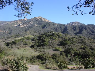
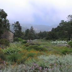
The Santa Ynez Mountains form an east-west chain extending from Santa Barbara County into Ventura County near the Pacific Ocean. The range is composed of sedimentary rock layers that tell the story of ancient geological processes.

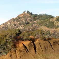
The oldest rocks here belong to the Juncal Formation, which formed from ancient sea sediments and has shaped the landscape over millions of years. The tilted rock layers visible today show how the mountains rose and transformed over time.

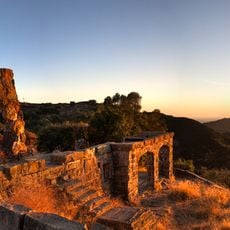
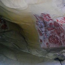
The Chumash people made their home in these mountains long ago, leaving behind rock paintings that visitors can still see at Painted Cave State Historic Park. These artworks tell the story of how they lived and moved through this land.

Two passes cut through the mountains and allow vehicle traffic: Gaviota Pass and San Marcos Pass connect the coast to the Santa Ynez Valley. Check local conditions before driving, as weather can affect road access in either direction.

The mountain slopes display noticeably tilted rock layers of Cozy Dell Shale, created from fine sea mud long ago. These angled strata are visible reminders of the powerful forces that shaped the landscape over geological time.

The community of curious travelers

AroundUs brings together thousands of curated places, local tips, and hidden gems, enriched daily by 60,000 contributors worldwide.

Start exploring
Made from material
sedimentary rock
GPS coordinates
34.50090,-119.72969
Latest update
December 20, 2025 12:43
Around this place
Mission Santa Barbara
United States of America

Mission Santa Barbara

7.1 km
Knapp's Castle
United States of America

Knapp's Castle

6.3 km
Presidio of Santa Barbara
United States of America

Presidio of Santa Barbara

9.2 km
Lotusland
United States of America

Lotusland

9.3 km
Santa Barbara Bowl
United States of America

Santa Barbara Bowl

8.3 km
Santa Barbara County Courthouse
United States of America

Santa Barbara County Courthouse

8.9 km
Chumash Painted Cave State Historic Park
United States of America

Chumash Painted Cave State Historic Park

5.4 km
Santa Barbara Museum of Natural History
United States of America

Santa Barbara Museum of Natural History

6.8 km
Karpeles Manuscript Library Museums
United States of America

Karpeles Manuscript Library Museums

9 km
Santa Barbara Museum of Art
United States of America

Santa Barbara Museum of Art

9 km
Santa Barbara Botanic Garden
United States of America

Santa Barbara Botanic Garden

5.6 km
Gibraltar Dam
United States of America

Gibraltar Dam

4.9 km
Lobero Theatre
United States of America

Lobero Theatre

9.2 km
Rafael Gonzalez House
United States of America

Rafael Gonzalez House

9.1 km
Our Lady of Sorrows Church
United States of America

Our Lady of Sorrows Church

8.6 km
La Cumbre Peak
United States of America

La Cumbre Peak

1.7 km
Casa Dolores
United States of America

Casa Dolores

9.4 km
Santa Barbara Historical Museum
United States of America

Santa Barbara Historical Museum

9.3 km
Paseo de la Guerra
United States of America

Paseo de la Guerra

9.4 km
Santa Barbara Mission-Archive Library
United States of America

Santa Barbara Mission-Archive Library

7.2 km
Thomas Hope House
United States of America

Thomas Hope House

8.3 km
Hill-Carrillo Adobe
United States of America

Hill-Carrillo Adobe

9.2 km
Janssens-Orella-Birk Building
United States of America

Janssens-Orella-Birk Building

9.1 km
Trinity Episcopal Church
United States of America

Trinity Episcopal Church

8.5 km
Rocky Nook Park
United States of America

Rocky Nook Park

6.7 km
Granada Theater
United States of America

Granada Theater

8.9 km
A.C. Postel Memorial Rose Garden
United States of America

A.C. Postel Memorial Rose Garden

7.2 km
Rattlesnake Canyon Bridge
United States of America

Rattlesnake Canyon Bridge

5.9 km
Show the full map
Reviews
Share your experience

No review yet

Discussions
Start a discussion...

No discussion yet

« Santa Ynez Mountains - Mountain range in Santa Barbara County, United States » is provided by Around Us (aroundus.com). Images and texts are derived from Wikimedia project under a Creative Commons license. You are allowed to copy, distribute, and modify copies of this page, under the conditions set by the license, as long as this note is clearly visible.

Discover hidden gems everywhere you go!

From secret cafés to breathtaking viewpoints, skip the crowded tourist spots and find places that match your style. Our app makes it easy with voice search, smart filtering, route optimization, and insider tips from travelers worldwide. Download now for the complete mobile experience.

Around Us App Screenshot

A unique approach to discovering new places

Le Figaro

All the places worth exploring

France Info

A tailor-made excursion in just a few clicks

20 Minutes

Around Us
Travel Guide & Maps
Download

Send to your phone

QR Code
1

Open the camera app on your mobile.

2

Point at the QR code with your camera. A notification will appear.

3

Tap the notification to open the link.