Chest opened
+${chestReward.xp} XP
Explorer
NOUVEAU ×${chestReward.collectible.quantity}
tapez pour fermer
Chest locked

Open chests in the app

Around Us is built for your phone — chests unlock when you walk, explore and capture nearby places.

Enable Location

We need your location to show you interesting places around you

Discover nearby places

Find interesting locations and hidden gems around you

Precise directions

Get accurate directions and distances to places

Your location is never shared with other users. It's only used when you tap the location button.

Rosamond

Log in to your account

Start exploring — it's free

Trusted by 72,954 travelers worldwide

Continue with Google
Continue with Apple
or

We will send you a code to connect

By continuing, you accept our Terms and Conditions and our Privacy Policy

Check your inbox

We've sent a pincode in your inbox. Please enter the code below.

Discussion Reviews 1 Photos
29.6k Popularity

Rosamond, Census-designated place in Kern County, California.

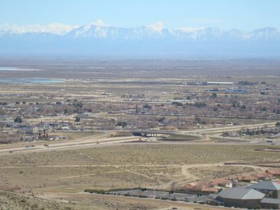
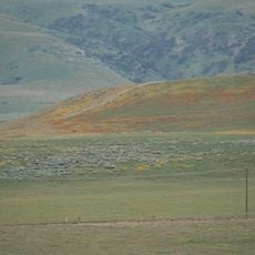
Rosamond is a census-designated place in the Mojave Desert within Kern County, California, positioned north of Lancaster and Palmdale. The town sits on elevated terrain with heights ranging between 2,000 and 3,000 feet above sea level.

The town was founded in 1877 when the Southern Pacific Railroad established a station at this location. The area later experienced two separate gold mining booms, once in the 1890s and again during the 1930s.

The population consists of diverse communities, with significant White, African American, Native American, and Hispanic or Latino residents forming the local demographics.

California State Route 14 provides road access connecting the town to Los Angeles and Mojave in different directions. Bus services through Kern Transit offer connections to larger cities including Bakersfield and Lancaster for those without a vehicle.

In 1932, racing driver Eddie Pullen set a durability record near this location, pushing a Ford V-8 engine through extreme desert conditions over multiple weeks. This feat gained attention as a demonstration of automotive reliability in harsh environments.

The community of curious travelers

AroundUs brings together thousands of curated places, local tips, and hidden gems, enriched daily by 60,000 contributors worldwide.

Start exploring
Location
Elevation above the sea
767 m
Shares border with
Lancaster
GPS coordinates
34.86583,-118.20694
Latest update
December 20, 2025 11:23
Around this place
Willow Springs International Motorsports Park
United States of America

Willow Springs International Motorsports Park

5.3 km
United States of America

California State Prison, Los Angeles County

19.2 km
United States of America

Museum of Art and History

19.6 km
Fairmont Butte
United States of America

Fairmont Butte

22.5 km
Western Hotel
United States of America

Western Hotel

19.6 km
Willow Springs Canyon
United States of America

Willow Springs Canyon

22.1 km
Moah:cedar
United States of America

Moah:cedar

19.7 km
Century Circle
United States of America

Century Circle

19.8 km
United States of America

Work of art, sculpture

20.8 km
United States of America

Work of art

21 km
United States of America

Skidpad

4.6 km
United States of America

F-4 Phantom II

19.7 km
United States of America

One Desert Sky

19.5 km
United States of America

Work of art, sculpture

20.8 km
United States of America

Race Car Paddock

5.2 km
United States of America

Work of art

19.4 km
United States of America

Work of art

19.4 km
United States of America

Test Facility Race Car Paddock Area

4.9 km
United States of America

Antelope Butte Vista Point

20.8 km
United States of America

Kitanemuk Vista Point

22.2 km
United States of America

Vista Valley Point

22.5 km
United States of America

McDonnell Douglas YC-15A

19.8 km
United States of America

North American YF-100A Super Sabre

19.7 km
United States of America

McDonnell F-101B Voodoo

19.7 km
United States of America

Convair QF-106B Delta Dart

19.8 km
United States of America

Republic F-105D Thunderchief

19.8 km
United States of America

Lockheed F-104G Starfighter

19.8 km
United States of America

Convair TF-102A Delta Dagger

19.7 km
Show the full map
Reviews
Share your experience

No review yet

Discussions
Start a discussion...

No discussion yet

« Rosamond - Census-designated place in Kern County, California » is provided by Around Us (aroundus.com). Images and texts are derived from Wikimedia project under a Creative Commons license. You are allowed to copy, distribute, and modify copies of this page, under the conditions set by the license, as long as this note is clearly visible.

Discover hidden gems everywhere you go!

From secret cafés to breathtaking viewpoints, skip the crowded tourist spots and find places that match your style. Our app makes it easy with voice search, smart filtering, route optimization, and insider tips from travelers worldwide. Download now for the complete mobile experience.

Around Us App Screenshot

A unique approach to discovering new places

Le Figaro

All the places worth exploring

France Info

A tailor-made excursion in just a few clicks

20 Minutes

Around Us
Travel Guide & Maps
Download

Send to your phone

QR Code
1

Open the camera app on your mobile.

2

Point at the QR code with your camera. A notification will appear.

3

Tap the notification to open the link.