California City

Log in to your account

AroundUs is a community-driven map of interesting places, built by curious explorers like you. It grows with every review, story, and photo you share.
Connect to save your favorite spots, contribute locations, and create personalized routes.
By continuing, you accept our Terms and Conditions and our Privacy Policy
Add to collection
Map
Suggest a change
Share

California City, Desert municipality in Antelope Valley, United States

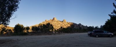
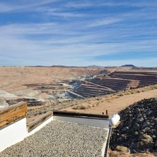
California City is a desert municipality in the Antelope Valley of California, covering more than 200 square miles (520 square kilometers) of Mojave Desert terrain. The town sits in Kern County, roughly 100 miles (160 kilometers) north of Los Angeles, and consists mostly of undeveloped land with a smaller inhabited center.

Real estate developers began purchasing roughly 82,000 acres (33,000 hectares) of desert land in 1958 to create a new major city north of Los Angeles. The project never reached its planned size, and the community was officially incorporated as a city in 1965.

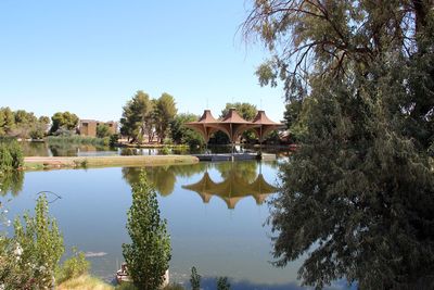
The sprawling, often empty street grid tells the story of an original plan that expected far more residents than actually arrived. Many lots remain vacant while daily life concentrates in a smaller core where shops and restaurants serve the few thousand inhabitants.

Desert temperatures swing widely, with hot summer days and cool nights, so plan accordingly. Most facilities lie along Central Boulevard and California City Boulevard, where gas stations, grocery stores, and restaurants can be found.

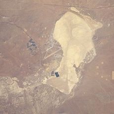
The town was designed for a population of several hundred thousand people, yet today only around 15,000 live here. Large sections of paved streets lead nowhere and end abruptly in the desert, giving the whole place an almost ghostly feel.

Location: Kern County

Inception: December 10, 1965

Elevation above the sea: 733 m

Part of: Antelope Valley

Address: California City, CA, USA

Website: http://californiacity.com

GPS coordinates: 35.12583,-117.98583

Latest update: December 4, 2025 19:02

Around this place
Show the full map
Tehachapi Loop
United States of America

Tehachapi Loop

50.8 km
Willow Springs International Motorsports Park
United States of America

Willow Springs International Motorsports Park

37.7 km
Red Rock Canyon State Park
United States of America

Red Rock Canyon State Park

27.5 km
California Correctional Institution
United States of America

California Correctional Institution

53.1 km
Burro Schmidt Tunnel
United States of America

Burro Schmidt Tunnel

33.2 km
Rogers Dry Lake
United States of America

Rogers Dry Lake

26.9 km
Tehachapi Pass
United States of America

Tehachapi Pass

27.2 km
Jawbone Canyon
United States of America

Jawbone Canyon

20.9 km
Walker Pass
United States of America

Walker Pass

59.9 km
Antelope Valley Indian Museum State Historic Park
United States of America

Antelope Valley Indian Museum State Historic Park

54.4 km
Saddleback Butte State Park
United States of America

Saddleback Butte State Park

53.1 km
Robbers Roost
United States of America

Robbers Roost

52 km
Bright Star Wilderness
United States of America

Bright Star Wilderness

48.4 km
Double Mountain
United States of America

Double Mountain

46.8 km
Maturango Museum
United States of America

Maturango Museum

63.1 km
Last Chance Canyon
United States of America

Last Chance Canyon

27.9 km
Naval Museum of Armament & Technology
United States of America

Naval Museum of Armament & Technology

66.6 km
ESMoA
United States of America

ESMoA

32.6 km
Western Hotel
United States of America

Western Hotel

49.6 km
Errea House
United States of America

Errea House

42 km
Courtlandt Gross House
United States of America

Courtlandt Gross House

49.3 km
Tehachapi Depot Museum
United States of America

Tehachapi Depot Museum

42.1 km
Mournig Cloak Ranch and Botanical Gardens
United States of America

Mournig Cloak Ranch and Botanical Gardens

42.2 km
Rio Tinto Borax Mine Visitor Center
United States of America

Rio Tinto Borax Mine Visitor Center

29.2 km
Blackbird Airpark
United States of America

Blackbird Airpark

58.9 km
Moah:cedar
United States of America

Moah:cedar

49.7 km
Elyze Clifford Interpretive Center
United States of America

Elyze Clifford Interpretive Center

54.4 km
Century Circle
United States of America

Century Circle

28.3 km
Show the full map

Reviews

Visited this place? Tap the stars to rate it and share your experience / photos with the community! Try now! You can cancel it anytime.

« California City - Desert municipality in Antelope Valley, United States » is provided by Around Us (aroundus.com). Images and texts are derived from Wikimedia project under a Creative Commons license. You are allowed to copy, distribute, and modify copies of this page, under the conditions set by the license, as long as this note is clearly visible.

Discover hidden gems everywhere you go!

From secret cafés to breathtaking viewpoints, skip the crowded tourist spots and find places that match your style. Our app makes it easy with voice search, smart filtering, route optimization, and insider tips from travelers worldwide. Download now for the complete mobile experience.

Around Us App Screenshot

A unique approach to discovering new places

Le Figaro

All the places worth exploring

France Info

A tailor-made excursion in just a few clicks

20 Minutes