Enable Location

We need your location to show you interesting places around you

Discover nearby places

Find interesting locations and hidden gems around you

Precise directions

Get accurate directions and distances to places

Your location is never shared with other users. It's only used when you tap the location button.

Arrastra Mountain Wilderness

Log in to your account

Start exploring — it's free

Trusted by 62,574 travelers worldwide

Continue with Google
Continue with Apple
or

We will send you a code to connect

By continuing, you accept our Terms and Conditions and our Privacy Policy

Check your inbox

We've sent a pincode in your inbox. Please enter the code below.

Arrastra Mountain Wilderness

Arrastra Mountain Wilderness, Protected wilderness area in Mohave, Yavapai, and La Paz Counties, Arizona.

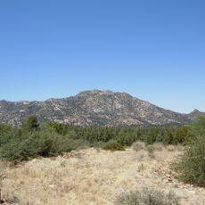
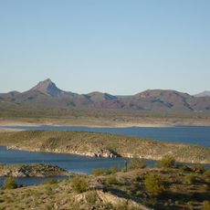
Arrastra Mountain Wilderness is a protected wilderness area spanning roughly 129,800 acres across three Arizona counties with volcanic formations and river systems. The Poachie Range rises to 5,000 feet (1,524 m) and defines much of the geological character across this expansive terrain.

The Arizona Desert Wilderness Act of 1990 established this area under management by the Bureau of Land Management Colorado River District. This designation protected the land from most industrial development and preserved its natural character.

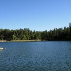
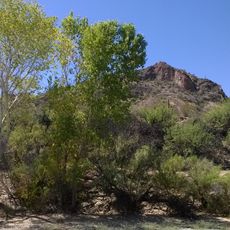
The natural pools of Peoples Canyon stretch for two miles with hundreds of native sycamores, willows, and cottonwoods that frame the water. These green corridors reflect how life in the desert gathers where water flows, making them important landmarks for those exploring the region.

Visitors need high-clearance vehicles to access the wilderness via 17-Mile Road from Highway 93 or through Palmerita Ranch from Wickenburg. The terrain is remote and rough, requiring preparation and suitable equipment for safe exploration.

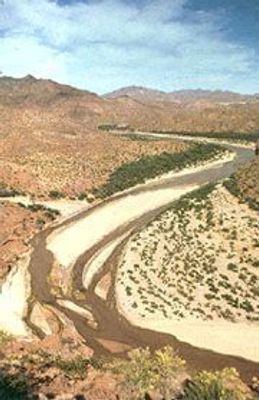
Artillery Peak stands as a distinctive 1,200-foot (366 m) volcanic plug west of Big Sandy River that draws the eye across the landscape. Orange mudstone formations shape the southern mountain edges and create a striking visual contrast in the otherwise sparse terrain.

The community of curious travelers

AroundUs brings together thousands of curated places, local tips, and hidden gems, enriched daily by 60,000 contributors worldwide.

Start exploring
Location
GPS coordinates
34.48028,-113.26417
Latest update
December 14, 2025 14:41
Around this place
Alamo Lake State Park
United States of America

Alamo Lake State Park

41.6 km
Fort Whipple
United States of America

Fort Whipple

74.6 km
Granite Mountain
United States of America

Granite Mountain

65.5 km
Sharlot Hall Museum
United States of America

Sharlot Hall Museum

72.8 km
Goldwater Lake
United States of America

Goldwater Lake

74.8 km
United States of America

Granite Basin Lake

67.3 km
Bucky O'Neill Monument
United States of America

Bucky O'Neill Monument

73.3 km
Yavapai County Courthouse
United States of America

Yavapai County Courthouse

73.2 km
Prescott Observatory
United States of America

Prescott Observatory

71.1 km
Prescott Public Library
United States of America

Prescott Public Library

73.5 km
Smoki Museum
United States of America

Smoki Museum

74.2 km
Prescott Elks Theater and Performing Arts Center
United States of America

Prescott Elks Theater and Performing Arts Center

73.4 km
Sacred Heart Catholic Church and Rectory
United States of America

Sacred Heart Catholic Church and Rectory

73.4 km
Garcia School
United States of America

Garcia School

74.9 km
Iron Turbine Windmill
United States of America

Iron Turbine Windmill

72.8 km
United States Post Office and Courthouse–Prescott Main
United States of America

United States Post Office and Courthouse–Prescott Main

73.2 km
First Congregational Church and Parsonage
United States of America

First Congregational Church and Parsonage

73.5 km
Alamo Lake
United States of America

Alamo Lake

41.6 km
Prescott Public Library
United States of America

Prescott Public Library

73.4 km
Wegner Peak
United States of America

Wegner Peak

31.4 km
Brinkmeyer House
United States of America

Brinkmeyer House

72.5 km
Courthouse Plaza Historic District
United States of America

Courthouse Plaza Historic District

73.2 km
Sloan House
United States of America

Sloan House

73.7 km
Fredericks House
United States of America

Fredericks House

73.6 km
Clark House
United States of America

Clark House

73.7 km
Detwiler House
United States of America

Detwiler House

73.6 km
Presbyterian Church (Prescott, Arizona)
United States of America

Presbyterian Church (Prescott, Arizona)

73.5 km
Granite Creek Bridge
United States of America

Granite Creek Bridge

73.1 km
Show the full map
« Arrastra Mountain Wilderness - Protected wilderness area in Mohave, Yavapai, and La Paz Counties, Arizona » is provided by Around Us (aroundus.com). Images and texts are derived from Wikimedia project under a Creative Commons license. You are allowed to copy, distribute, and modify copies of this page, under the conditions set by the license, as long as this note is clearly visible.

Discover hidden gems everywhere you go!

From secret cafés to breathtaking viewpoints, skip the crowded tourist spots and find places that match your style. Our app makes it easy with voice search, smart filtering, route optimization, and insider tips from travelers worldwide. Download now for the complete mobile experience.

Around Us App Screenshot

A unique approach to discovering new places

Le Figaro

All the places worth exploring

France Info

A tailor-made excursion in just a few clicks

20 Minutes

Around Us
Travel Guide & Maps
Download

Send to your phone

QR Code
1

Open the camera app on your mobile.

2

Point at the QR code with your camera. A notification will appear.

3

Tap the notification to open the link.