Enable Location

We need your location to show you interesting places around you

Discover nearby places

Find interesting locations and hidden gems around you

Precise directions

Get accurate directions and distances to places

Your location is never shared with other users. It's only used when you tap the location button.

Delano Peak

Log in to your account

Start exploring — it's free

Trusted by 62,959 travelers worldwide

Continue with Google
Continue with Apple
or

We will send you a code to connect

By continuing, you accept our Terms and Conditions and our Privacy Policy

Check your inbox

We've sent a pincode in your inbox. Please enter the code below.

Delano Peak
Discussion Reviews 1 Photos
4.3k Popularity

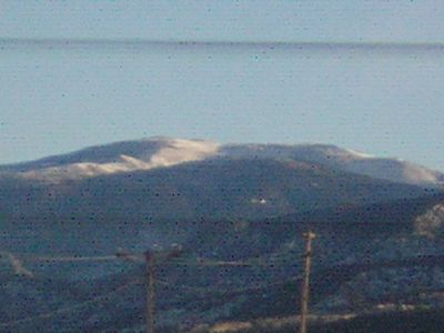
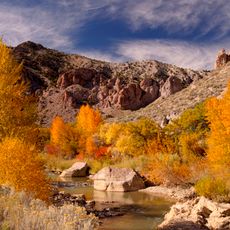
Delano Peak, Mountain summit in Beaver County, Utah, United States

Delano Peak is a mountain summit located where Beaver and Piute counties meet in Utah, standing at approximately 3,710 meters high. This elevation makes it the tallest point in both counties and shapes the skyline of the region.

The mountain was named after Columbus Delano, who served as U.S. Secretary of the Interior during Ulysses S. Grant's presidency. The naming reflects the era when the region was being mapped and officially documented.

The summit serves as a gathering place for regional mountaineers who maintain a visitor register inside a metal box at the top. Those who reach the peak can read entries from previous hikers and leave their own messages.

The climb from Big John Flat follows a clear trail and takes about two to four hours to reach the summit under normal conditions. Starting early is wise, and be prepared for sudden weather changes due to the elevation.

The summit area regularly hosts a mountain goat population that sometimes exceeds thirty individuals. This herd is visible and offers visitors opportunities to observe wildlife during the climb.

The community of curious travelers

AroundUs brings together thousands of curated places, local tips, and hidden gems, enriched daily by 60,000 contributors worldwide.

Start exploring
Location
Location
Elevation above the sea
3,710 m
GPS coordinates
38.36914,-112.37132
Latest update
December 11, 2025 11:02
Around this place
Fremont Indian State Park and Museum
United States of America

Fremont Indian State Park and Museum

23.4 km
Fort Cameron
United States of America

Fort Cameron

22.4 km
Frisco Charcoal Kilns
United States of America

Frisco Charcoal Kilns

13.9 km
Marysvale Canyon
United States of America

Marysvale Canyon

18.8 km
Meeting Hall
United States of America

Meeting Hall

25.3 km
Piute County Courthouse
United States of America

Piute County Courthouse

19.8 km
Samuel Jackson House
United States of America

Samuel Jackson House

25.6 km
Beaver County Courthouse
United States of America

Beaver County Courthouse

25.6 km
Beaver Relief Society Meetinghouse
United States of America

Beaver Relief Society Meetinghouse

25.7 km
Erickson House
United States of America

Erickson House

26 km
Beaver City Library
United States of America

Beaver City Library

25.9 km
Sarah Eliza Harris House
United States of America

Sarah Eliza Harris House

25.1 km
James Boyter House
United States of America

James Boyter House

25.7 km
John and Ella Morrill House
United States of America

John and Ella Morrill House

19.7 km
Beaver Opera House
United States of America

Beaver Opera House

25.7 km
Feargus O'Connor Willden House
United States of America

Feargus O'Connor Willden House

25.7 km
Julia Farnsworth House
United States of America

Julia Farnsworth House

26 km
Charles Dennis White House
United States of America

Charles Dennis White House

25.4 km
William Burt House
United States of America

William Burt House

25 km
Edward Bird House
United States of America

Edward Bird House

25.5 km
Alma Crosby House
United States of America

Alma Crosby House

25.5 km
Atkins and Smith House
United States of America

Atkins and Smith House

26.1 km
Edward Fernley House
United States of America

Edward Fernley House

25.3 km
Dr. George Fennemore House
United States of America

Dr. George Fennemore House

26 km
James Fennemore House
United States of America

James Fennemore House

25.5 km
Louis W. Harris House
United States of America

Louis W. Harris House

25.1 km
Julia P.M. Farnsworth Barn
United States of America

Julia P.M. Farnsworth Barn

26 km
Bullion Canyon
United States of America

Bullion Canyon

8.3 km
Show the full map
Reviews
Share your experience

No review yet

Discussions
Start a discussion...

No discussion yet

« Delano Peak - Mountain summit in Beaver County, Utah, United States » is provided by Around Us (aroundus.com). Images and texts are derived from Wikimedia project under a Creative Commons license. You are allowed to copy, distribute, and modify copies of this page, under the conditions set by the license, as long as this note is clearly visible.

Discover hidden gems everywhere you go!

From secret cafés to breathtaking viewpoints, skip the crowded tourist spots and find places that match your style. Our app makes it easy with voice search, smart filtering, route optimization, and insider tips from travelers worldwide. Download now for the complete mobile experience.

Around Us App Screenshot

A unique approach to discovering new places

Le Figaro

All the places worth exploring

France Info

A tailor-made excursion in just a few clicks

20 Minutes

Around Us
Travel Guide & Maps
Download

Send to your phone

QR Code
1

Open the camera app on your mobile.

2

Point at the QR code with your camera. A notification will appear.

3

Tap the notification to open the link.