Enable Location

We need your location to show you interesting places around you

Discover nearby places

Find interesting locations and hidden gems around you

Precise directions

Get accurate directions and distances to places

Your location is never shared with other users. It's only used when you tap the location button.

Massacre Rocks State Park

Log in to your account

Start exploring — it's free

Trusted by 61,319 travelers worldwide

Continue with Google
Continue with Apple
or

We will send you a code to connect

By continuing, you accept our Terms and Conditions and our Privacy Policy

Check your inbox

We've sent a pincode in your inbox. Please enter the code below.

Massacre Rocks State Park

Massacre Rocks State Park, State park in Power County, Idaho, US

Description

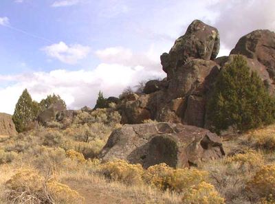
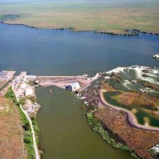
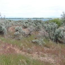
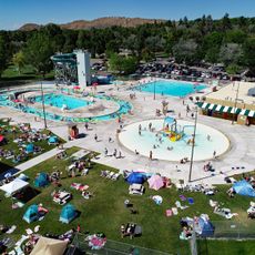
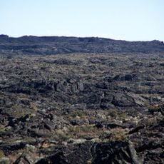
Massacre Rocks State Park is a state park along the Snake River in Power County, Idaho, covering roughly 990 acres. The park includes volcanic rock formations, hiking trails, a disc golf course, and several recreation areas next to the river.

History

The site witnessed an armed conflict between Oregon Trail settlers and Shoshone people in 1862. The confrontation resulted in deaths on both sides and shaped how this section of the route was remembered.

Culture

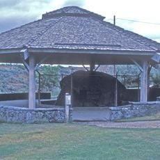
Register Rock carries carved names and dates left by travelers who paused here during their westward journey in the 19th century. The inscriptions offer a direct glimpse into the individuals who moved along the Oregon Trail and show how this stopping point mattered to those passing through.

Practical

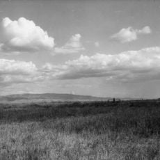
The park offers camping areas, boat ramps, and fishing spots accessible from Interstate 86. The site remains open daily, and trails wind through open terrain with views of the river.

Did you know?

The rock formations were carried here during the Bonneville Flood, when water from a prehistoric lake swept across the region. The force of the flood was strong enough to move entire boulders over long distances.

Location
Inception
1967
GPS coordinates
42.72669,-112.93300
Latest update
December 5, 2025 22:29

AroundUs brings together thousands of curated places, local tips, and hidden gems, enriched daily by 60,000 contributors worldwide. Discover all places nearby (Power County).

Around this place
Fort Hall
United States of America

Fort Hall

40.7 km
Holt Arena
United States of America

Holt Arena

44.2 km
American Falls Dam
United States of America

American Falls Dam

7.6 km
Pocatello Idaho Temple
United States of America

Pocatello Idaho Temple

47.8 km
Register Rock
United States of America

Register Rock

10.7 km
Lake Walcott State Park
United States of America

Lake Walcott State Park

44.9 km
Lake Walcott
United States of America

Lake Walcott

35.4 km
Idaho Museum of Natural History
United States of America

Idaho Museum of Natural History

43.7 km
Minidoka National Wildlife Refuge
United States of America

Minidoka National Wildlife Refuge

37.8 km
Zoo Idaho
United States of America

Zoo Idaho

43.7 km
St. Joseph's Catholic Church
United States of America

St. Joseph's Catholic Church

41.8 km
Standrod House
United States of America

Standrod House

41.8 km
Idaho State Arboretum
United States of America

Idaho State Arboretum

43.4 km
Church of the Assumption
United States of America

Church of the Assumption

42.9 km
Empire School
United States of America

Empire School

61.6 km
Idaho State University Administration Building
United States of America

Idaho State University Administration Building

43.5 km
Power County Courthouse
United States of America

Power County Courthouse

9.3 km
A.F.R. Building
United States of America

A.F.R. Building

42.1 km
Walter Sparks House
United States of America

Walter Sparks House

9.2 km
Rupert Town Square Historic District
United States of America

Rupert Town Square Historic District

61.7 km
Pocatello Carnegie Library
United States of America

Pocatello Carnegie Library

42 km
Sullivan-Kinney House
United States of America

Sullivan-Kinney House

42.2 km
John Hood House
United States of America

John Hood House

43.3 km
Ross Park Aquatic Complex
United States of America

Ross Park Aquatic Complex

43.6 km
United States of America

Oneida Milling and Elevator Company Grain Elevator

8.4 km
Idaho Museum of Natural History
United States of America

Idaho Museum of Natural History

43.4 km
Wapi Lava Field
United States of America

Wapi Lava Field

29 km
McCammon Overhead and River Crossing Bridge
United States of America

McCammon Overhead and River Crossing Bridge

60.9 km
Show the full map
« Massacre Rocks State Park - State park in Power County, Idaho, US » is provided by Around Us (aroundus.com). Images and texts are derived from Wikimedia project under a Creative Commons license. You are allowed to copy, distribute, and modify copies of this page, under the conditions set by the license, as long as this note is clearly visible.

Discover hidden gems everywhere you go!

From secret cafés to breathtaking viewpoints, skip the crowded tourist spots and find places that match your style. Our app makes it easy with voice search, smart filtering, route optimization, and insider tips from travelers worldwide. Download now for the complete mobile experience.

Around Us App Screenshot

A unique approach to discovering new places

Le Figaro

All the places worth exploring

France Info

A tailor-made excursion in just a few clicks

20 Minutes

Around Us
Travel Guide & Maps
Download

Send to your phone

QR Code
1

Open the camera app on your mobile.

2

Point at the QR code with your camera. A notification will appear.

3

Tap the notification to open the link.